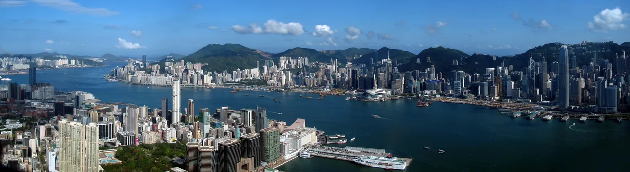

Victoria Harbour
The explorer Zheng He passed through these waters in the early fifteenth century. His sailing maps of the China coast, compiled around 1425 and preserved in the seventeenth-century military compendium Wubei Zhi, contain the first known reference to what would eventually be called Victoria Harbour. He was not naming it. He was noting it — a deep, sheltered channel between an island and a peninsula, useful and well-positioned on the South China Sea. Four centuries later, the British would find it just as useful, and the colony they founded around it would reshape this part of the world entirely.
Why the Harbour Made Hong Kong
Natural harbours are not common. What Victoria Harbour offered — deep water close to shore, shelter from typhoons, strategic position on the trade routes between China and the wider Pacific — was rare enough to justify the British decision in 1841 to establish a colony here rather than anywhere else. The harbour was originally called Hong Kong Harbour. It was renamed Victoria Harbour in honor of the queen, to mark its incorporation into the British fleet's sphere of protection. The gesture was partly symbolic and partly practical: a named harbour was a claimed harbour. The colony built outward from that claim, and the harbour became the engine of everything that followed: trade, commerce, immigration, and eventually one of the densest urban environments on earth.
Water Sports, Rebellion, and Pollution
In the 1850s, members of Hong Kong's first sports club, the Victoria Recreation Club, swam and played water polo in the harbour. The water was clean enough then. That same decade, during the Taiping Rebellion, Taiping war boats and Chinese imperial forces nearly fought a naval battle in the harbour before British colonial authorities intervened and ordered the imperial defenders away — a moment of tension that contributed to the Arrow War. By the 1970s, the manufacturing boom had changed the harbour's character entirely. Pollution from industrial discharges and from the Pearl River Delta's nitrogen-laden outflow made the water club races impossible; they stopped in 1973. The harbour that had once hosted recreational swimmers now carried the residue of the factories that had made Hong Kong prosperous.
Reclamation and What It Cost
Throughout Hong Kong's history, the harbour has been shrinking. Land reclamation on both shores — the process of dumping fill into the water to extend the land surface — has consumed significant portions of what was once open water. Former islands including Stonecutters Island, Kellett Island, and Hoi Sham Island are now connected to adjacent land, swallowed by reclamation projects. The narrowing of the harbour has been controversial. NGOs, including the Society for Protection of the Harbour, formed specifically to resist further reduction of the water body. Christine Loh, the Society's chairman, described the harbour as a precious national asset. Reclamation work demolished Queen's Pier and Edinburgh Place Ferry Pier, both structures of historic significance, to massive public opposition. The debate about how much of the harbour to sacrifice for land — and for whose benefit — has never been fully resolved.
The View Everyone Knows
Victoria Harbour is one of the most photographed urban views on earth. The skyline of Hong Kong Island — a wall of skyscrapers rising from the waterfront, backed by the steep ridges of the Peak — reflected in the dark water at night is the image that defines the city internationally. The best vantage points are from Victoria Peak itself, from the promenade at Tsim Sha Tsui on the Kowloon side, and from the Cultural Centre piazza. The harbour hosts annual fireworks displays on the second night of the Lunar New Year, broadcast on local television and watched from both shores. The nightly light show A Symphony of Lights illuminates buildings on both sides of the water simultaneously. The Avenue of Stars on the Kowloon waterfront, modeled on the Hollywood Walk of Fame, honors figures from the Hong Kong film industry. All of it — the light shows, the promenades, the fireworks — is staged for and around the harbour.
A Working Port
Underneath the tourism, the harbour remains a serious port. Around 100,000 ocean-going and river-trade vessels visit each year. The Kwai Tsing Container Terminals at the western end of the harbour operate around the clock. In 2016, some 19.8 million containers — measured in twenty-foot equivalent units — passed through. About 400 container ships serve Hong Kong weekly, connecting to more than 500 destinations worldwide. Four MTR lines run under the harbour in tunnels. Three road tunnels cross it. The Star Ferry, running its green-and-white double-decked boats between Central and Tsim Sha Tsui since the late nineteenth century, still crosses it for the cost of a few dollars. The harbour that made Hong Kong a colony is still doing the work that made Hong Kong a city.
From the Air
Victoria Harbour lies at approximately 22.290°N, 114.170°E between Hong Kong Island to the south and the Kowloon Peninsula to the north. From cruising altitude, the harbour is one of the most distinctive geographic features in the region — a dark channel of water separating two densely built urban areas, framed by the ridge of the island to the south and the flat urban sprawl of Kowloon extending north toward the New Territories. The skyline of Hong Kong Island's financial district is unmistakable from any approach angle. Hong Kong International Airport (VHHH) is on Lantau Island to the west; inbound aircraft on ILS approaches cross the harbour at low altitude. The former Kai Tak Airport runway extended directly into the harbour's eastern end; the site is now the Kai Tak cruise terminal.
Nearby Stories
- Lok Ma Chau Loop 2.3 km away
- Portas do Cerco 2.3 km away
- Kweilin Incident 17 km away
- Wanshan Archipelago Campaign 34 km away
- Nanxiong Formation 115 km away
- Battle of Nanpeng Island 148 km away
- Heyuan 169 km away
- Cape Maobitou 632 km away