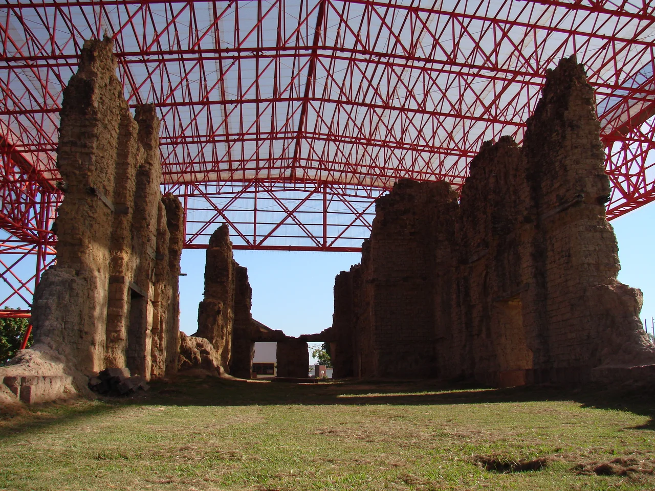

Vila Bela da Santíssima Trindade
When the colonial elite finally gave up on Vila Bela, they packed what they could and moved the whole capital eastward, leaving the heat, the river, and the people they had brought here in chains. The wealthy white families left. The Black families, most of them descended from enslaved Africans and from the quilombos hidden along the Guaporé, did not. They stayed in the abandoned capital of Mato Grosso and made it their own. Today a visitor to this remote corner of western Brazil could be forgiven for thinking they had wandered into a town in West Africa rather than the Amazon, and that impression is no accident. It is the long echo of a history that refused to be erased.
A Capital on the Edge of an Empire
Vila Bela was founded on March 19, 1752, by Captain Antônio Rolim de Moura, sent with royal orders to plant a Portuguese government on a contested frontier. Gold had been found in the Guaporé River region, and the crown needed a capital here to hold the line against Spanish expansion pressing from the west. For nearly seventy years Vila Bela served as the first capital of the captaincy of Mato Grosso, a lonely outpost of empire thousands of kilometers from the coast, its fortunes rising and falling with the gold pulled from the rivers and the forest of the Chapada dos Parecis.
The People Who Stayed
The gold that built Vila Bela was dug largely by enslaved Africans, brought across an ocean to work the riverbeds of a place most had never heard named. Many escaped into the surrounding forest and formed quilombos, self-governing communities of the formerly enslaved. When the colonial administration moved the capital away and the gold played out, the white planters followed the money. The descendants of the enslaved and the quilombolas remained, and over generations they became the town itself. What survives in Vila Bela today is not a relic of conquest but the living culture of the people conquest tried to own, carried forward on their own terms.
The Festa do Congo
Every year the town holds the Festa do Congo, a festival that braids African, Portuguese, and Indigenous traditions into something wholly Brazilian. Its centerpiece is the Dança do Congo, a dramatized performance in which an all-male company stages a confrontation between the kingdoms of Congo and Guinea, offered in honor of São Benedito, the patron saint of Black Brazilians. The dancers perform amid the ruins of the old colonial church, the broken igreja matriz, so that the celebration of survival unfolds quite literally on the bones of the empire that once ruled here. There is also the Chorado, a regional dance found almost nowhere else.
The Ruined Church
The town's most haunting landmark is what remains of that mother church. Construction began in 1771, late in Vila Bela's life as a capital, and it was never finished as the settlement slid into decline. Its weathered walls, listed as national heritage by Brazil's IPHAN in 1988, still stand open to the sky, framing the festival dances and the small history museum nearby. Roofless and unfinished, the ruin is a fitting monument to a place that was abandoned by power and reclaimed by the people who endured it, a church that was never completed for a story that is still being written.
From the Air
Vila Bela da Santíssima Trindade lies at 15.01°S, 59.95°W on the upper Guaporé River in western Mato Grosso, Brazil, hard against the Bolivian border and about 540 km west of the state capital, Cuiabá. From the air, the meandering Guaporé River is the dominant feature, threading between Brazil and Bolivia, with the town set on the Brazilian bank amid forest and seasonally flooded plains. The nearest sizable airfields are in Rondônia to the west, including Vilhena (ICAO SBVH), and at Cáceres and Cuiabá to the east; the town itself has only a small local strip. Recommended viewing altitude is 3,000 to 6,000 feet to take in both the river bends and the town grid, with the roofless ruins of the igreja matriz visible at the center. The dry season from May to September offers the clearest air; the wet season floods the surrounding lowlands and brings heavy afternoon cloud.
Nearby Stories
- Serra Ricardo Franco State Park 42 km away
- Guaporé River 53 km away
- Noel Kempff Mercado National Park 72 km away
- St. Ignatius Cathedral, San Ignacio de Velasco 131 km away
- San Ignacio de Velasco 159 km away
- Santa Ana de Velasco 164 km away
- Pantanal Matogrossense National Park 347 km away
- Várzea Grande 359 km away