Wadi Halfa Salient
Two lines were drawn across the desert at different times, for different reasons, and they have never stopped disagreeing. In 1899, British and Egyptian negotiators fixed the southern border of Egypt at the 22nd parallel north - a clean latitude, ruler-straight across sand. In 1902, colonial administrators drew a second line that wobbled where the first one did not, swerving north along the Nile to put the riverside villages under Sudanese administration because they were easier to reach from the south. The gap between those two lines is the Wadi Halfa Salient: a nine-kilometer-wide finger of contested land, 210 square kilometers of Nile banks and desert, claimed by both countries and lived in by almost no one.
Two Lines on a Map
The geometry sounds simple until you look at it. Egypt wants the 1899 border - the neat parallel - because the salient and the much larger Halaib Triangle on the Red Sea would then belong to Cairo. Sudan wants the 1902 administrative line, which shifted those same areas to Khartoum's jurisdiction. Both countries also claim the salient, while the third orphaned piece of this colonial cartography - Bir Tawil, south of the 1899 line - is claimed by neither, a true terra nullius that internet provocateurs have occasionally declared themselves kings of. The Wadi Halfa Salient stays out of the headlines mostly because there is almost nothing left to argue over. Most of it is underwater.
Fifty-Two Villages
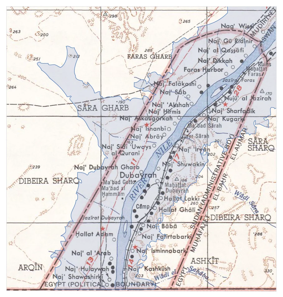
Before the Aswan High Dam closed in 1971, a detailed map from 1953 counted fifty-two villages inside the salient. Twenty-four stood west of the Nile, twenty-nine to the east, and one small settlement on Faras Island in the middle of the river. The largest was Dubayrah, with a population above two thousand - a proper town, with markets and palm groves, children and grandparents, an economy of fishing and date cultivation and small-boat trade that had continued along this stretch of Nile since pharaonic times. The Nubian city of Faras, with Christian frescoes from the Kingdom of Makuria that archaeologists rescued in a desperate campaign, stood within the salient too. All of it is gone now. Every village on the map disappeared into the reservoir.
New Halfa
The people did not go quietly. Some of the Nubians displaced from the Wadi Halfa area were resettled hundreds of kilometers to the east, to a place called New Halfa in the Butana region, where the climate and soil were nothing like the Nile valley their families had farmed for centuries. Many died from malaria and unfamiliar diseases in the new land. Others stayed near the old river, building and rebuilding settlements along the shifting shoreline as the reservoir kept rising in the early 1970s, finally settling the current town of Wadi Halfa well south of the old one. The salient, already a place most of whose residents had been forced to leave, became empty in a harder sense: a disputed territory where the thing being disputed had vanished.
Thirty Square Kilometers of Rock
What remains above water is perhaps thirty square kilometers of dry land, most of it on the eastern bank, a desolate rocky strip nearly devoid of vegetation. Satellite overlays of the 1953 map show how completely the flood transformed the geography. The finger-shaped extension that once held thousands of people reaching thirty kilometers north into Egypt now looks, from above, like a thin arc of exposed ridge above a still lake. The border disputes continue on paper. Diplomats in Cairo and Khartoum occasionally cite the 1899 agreement or the 1902 revision. But the salient itself keeps its own quiet counsel, drowned and rocky and mostly unreachable, a piece of the Egypt-Sudan border whose meaning receded with the water that covered it.
Ghost Cartography
From cruising altitude, the salient is almost impossible to see as a political boundary. Lake Nasser fills this region in a long, irregular blue mass, and neither the 1899 line nor the 1902 line is marked on the ground. What you might notice is the way the lake narrows and broadens, its margins following the drowned canyons of the pre-dam Nile. Somewhere beneath that water is Dubayrah. Somewhere nearby is Faras, its church walls collapsed long ago. The salient is a lesson in how borders outlive the places they were drawn to define - lines on a map persisting long after the villages, cemeteries, and family histories they once enclosed have been washed away.
From the Air
Coordinates: 22.092°N, 31.406°E. The Wadi Halfa Salient straddles the Egypt-Sudan border along the western arm of Lake Nasser. Most of the salient is underwater; look for the irregular lakeshore and the narrow eastern strip of exposed rock. Nearest airports: Abu Simbel (HEBL) 50 km north-northwest in Egypt, and Wadi Halfa (HSSW) about 25 km south in Sudan. Clear visibility essential; desert haze common. Recommended altitude 8,000-12,000 feet to see the full finger-shape of the salient against the reservoir.
Nearby Stories
- Wadi Halfa 9 km away
- Abu Simbel Phoenician graffiti 17 km away
- Kulb 86 km away
- Kulubnarti 116 km away
- Temple of Dendur 153 km away
- Bi'r Tawīl 181 km away
- Dar al-Manasir 316 km away
- Kharga Oasis 328 km away