
Washington Metropolitan Area
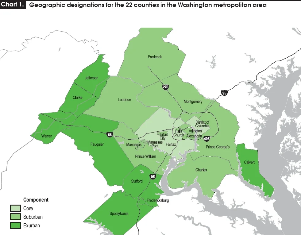
Locals call it the DMV, an abbreviation that started as slang and somehow stuck even on the lips of newscasters. The letters stand for District, Maryland, and Virginia, three jurisdictions that flow into one another along the Potomac and the Capital Beltway. From the air, the metropolitan area sprawls outward from a small federal diamond - just 68 square miles of Washington, D.C. - into Maryland's rolling counties and Northern Virginia's wooded suburbs, eventually nudging the Eastern Panhandle of West Virginia. More than 6.3 million people live here as of 2023, making this the country's seventh-most populous metropolitan area and, by most measures, one of its richest and best-educated.
Inside the Beltway
The Capital Beltway, Interstate 495, traces a sixty-four-mile circle around Washington. It gave the country a phrase - Inside the Beltway - that came to mean the closed loop of federal insiders and the people who lobby, write about, and depend on them. The Beltway isn't quite the boundary of the metro area; the suburbs spilled past it decades ago. But it remains the symbol, the line on every traffic report and political column. Cross it inbound and you enter the orbit of federal Washington. Cross it outbound and the strip malls and townhouse subdivisions start to look like anywhere else in suburban America, except richer, more degreed, and a little more wired into Washington's particular rhythm of news cycles and security clearances.
The Most Educated City in America
The Washington metropolitan area has ranked as the highest-educated metropolitan area in the United States for four decades running. Arlington County leads, with sixty-eight percent of adults over twenty-five holding a bachelor's degree. Fairfax County and Montgomery County trail close behind. Forbes once noted that the D.C. area is less than half the size of Los Angeles, but both have roughly 100,000 PhDs. That density of expertise shapes everything from the restaurants - which trend toward the cosmopolitan - to the conversations, which tend toward the policy-adjacent. It also produces the country's largest science and engineering workforce, anchored by the Dulles Technology Corridor and the federal research apparatus stretching from the National Institutes of Health in Bethesda to the National Geospatial-Intelligence Agency campus at Fort Belvoir.
The Two Washingtons
Wealth here is dramatic, and so is its distribution. A 2016 Urban Institute study found that the median net worth of white households in the D.C. region was $284,000. For Hispanic households it was $13,000. For Black households, $3,500. The same metro that overtook the San Francisco Bay Area as the country's highest-income region contains some of its starkest disparities. You see it in the geography: the Eden Center's Vietnamese restaurants in Falls Church, the Salvadoran pupuserias in Langley Park, the wealthy enclaves along the Potomac, and the historically Black neighborhoods east of the Anacostia River that experienced different versions of the same boom. These are not separate cities, but they are different Washingtons, and the distance between them is measured in more than miles.
An Economy Built on Government
Almost everything here, eventually, traces back to the federal government. Lockheed Martin, the country's largest defense contractor, is headquartered in Bethesda. General Dynamics, Northrop Grumman, BAE Systems, SAIC, Leidos - the Pentagon's surrounding orbit of contractors fills the office towers of Arlington and Tysons. Marriott, Hilton, and Ritz-Carlton are headquartered here, partly because federal travel filled their rooms for decades. The Washington Post, Politico, C-SPAN, NPR, and the country's second-largest concentration of journalists exist here to cover the government down the street. Even Amazon, which picked Crystal City in Arlington for its second headquarters in 2018, chose the location partly for proximity to federal procurement and the educated labor pool that grew up around it.
Layers of Place
Beneath the federal city is something older and more local. Alexandria's cobblestoned Old Town pre-dates the District itself, founded in 1749 by Scottish merchants. Annapolis, the Maryland capital, has been a working seaport since the 1600s. Out past the Beltway, the Civil War defenses of Washington still trace the high ground in earthen rings, and Antietam and Manassas battlefields sit within an easy drive. The region is also home to deep African American history - from the Anacostia Community Museum in southeast D.C. to the Underground Railroad routes that wove through the Maryland countryside. The federal capital is the headline, but the metro area is older, weirder, and more deeply rooted than the marble suggests.
From the Air
The Washington metropolitan area is centered near 38.89 N, 77.05 W. Reagan National (KDCA) sits on the Potomac just south of downtown; Dulles (KIAD) lies twenty-five miles west; Baltimore-Washington International (KBWI) is thirty miles northeast. The 2,000-foot Special Flight Rules Area around the National Capital Region requires prior coordination, and the Flight Restricted Zone over the District itself is closed to general aviation without explicit authorization. From 10,000 feet, the Capital Beltway is the clearest visual reference - a complete sixty-four-mile ring threaded by the Potomac, with the white marble of the National Mall visible near the river bend.
Nearby Stories
- Gunston Hall 1.1 km away
- 2023 Baltimore Shooting 4.9 km away
- Battle of Middleburg 6.6 km away
- Crownsville Hospital Center 10 km away
- Battle of Loudoun Heights 13 km away
- First Battle of Rappahannock Station 20 km away
- Howard County, Maryland 21 km away
- Harriet Tubman Underground Railroad 50 km away