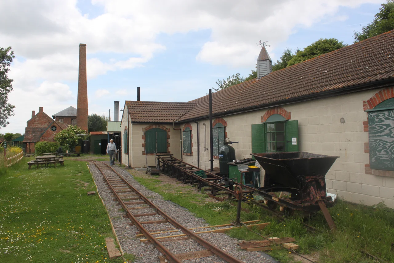

Westonzoyland Pumping Station Museum
In 1830 a brick chimney went up beside a rhyne in the village of Westonzoyland, and a beam engine began coughing smoke into the Somerset sky. For the first time in human history, somebody on the Levels was using mechanical power to push water uphill. The Romans had tried to drain this place; the monks of Glastonbury and Muchelney had built embankments here in the Middle Ages; the Dutch engineer Sir Cornelius Vermuyden had drawn up a scheme that the English Civil War destroyed. None of it had quite worked. The Westonzoyland engine worked. It worked so well that within decades pumping stations were going up across the Levels, and what had been salt marsh and floodland for a thousand years became the green agricultural plain that air travellers see today.
Drowned Country
The Somerset Moors and Levels are not really land. They are a reclaimed estuary: a coastal clay belt only slightly above mean sea level, with an inland peat belt at lower elevation behind it. For most of recorded history, large parts flooded with every winter rain and every high tide. The Romans may have made early attempts at drainage - records only date from the 13th century. The Domesday Book of 1086 mentions drainage of the higher grounds. The great medieval drainers were the abbeys of Glastonbury, Athelney and Muchelney, who built embankments along the River Parrett from around 1129 and reclaimed land parcel by parcel - 722 acres near Westonzoyland by 1234, 972 by 1240. The Abbot of Athelney diverted the River Tone into a new embanked channel. By 1500, of an estimated 70,000 acres of floodable land, only 20,000 had been reclaimed.
Vermuyden's Plan, the King's War
In the early 17th century, during the reign of James I, an ambitious plan to drain and enclose much of Sedgemoor was proposed. The local Lords supported it. The Commoners opposed it - they would lose their traditional grazing rights, which had sustained generations of small farmers on the seasonal flood pastures. In 1632 Charles I sold the Crown's interest to a consortium that included Sir Cornelius Vermuyden, the Dutch engineer who would later drain the Fens of East Anglia. The Civil War interrupted the project; later Parliament rejected it after sustained local opposition. By 1638 some 30,500 acres still drained no further than they had in the Middle Ages. Between 1785 and 1791, much of the lowest peat moor was finally enclosed under parliamentary acts. John Billingsley's 1795 Agriculture of the County of Somerset recorded the slow piecemeal progress: 4,400 acres at Wedmore, 2,000 at Mark, 1,700 at Westhay. But the basic problem remained. Once you dug rhynes (the local word for drainage channels, pronounced 'reens' to the east of Bridgwater and 'rhyne' to the west), the water had to go somewhere - and the Levels were so flat that gravity alone could not always move it.
Why Not Windmills?
The strange absence in the record is the windmill. In the Fens of East Anglia, wind power had been pumping drainage water since the 17th century - hundreds of small windpumps that lifted water from low fields into high drains. On the Somerset Levels, only two windmills are recorded: one at Bleadon at the mouth of the River Axe, one at Common Moor north of Glastonbury. Why so few? The answer was probably economic. The early steam pumps - Newcomen atmospheric engines - were even less efficient than windmills and prohibitively expensive to fuel with coal that had to be carted from elsewhere. The Levels' big landowners simply waited. By the early 19th century, the technology had advanced enough that the wait paid off.
1830, and What Came After
The first mechanical pumping station on the Levels was built at Westonzoyland in 1830 to drain Westonzoyland, Middlezoy and Othery. The original machine was a beam engine driving a scoop wheel - imagine a water wheel running backwards, scooping water from the rhyne up into the River Parrett. It worked, but it had a problem. The success of the drainage caused the peat itself to dry and shrink, lowering the land level. Within 25 years the scoop wheel was sitting too high above the water; in 1843 it was raised 15 inches but this was only a temporary fix. In 1861 the present machine was installed: an Easton and Amos twin-cylinder vertical condensing engine, designed by Charles Amos under a patent he had taken out in 1858, driving a centrifugal pump developed by John Appold. A similar engine had been shown at the Great Exhibition of 1851 lifting 100 tons of water a minute to a height of six feet. The Westonzoyland engine ran in continuous service until 1951, when changes to the local drainage system meant the steam pump could no longer reach the water and a 50-tons-per-minute diesel replacement was installed by the Environment Agency.
Restoration on a Charity's Budget
After 1951 the building stood unused. In 1976 members of the Somerset Industrial Archaeology Society began restoration work. The Westonzoyland Engine Trust gained charitable status in 1980 and in 1990 purchased the site outright from Wessex Water. Volunteers stabilised the engine house, rebuilt the chimney and pump house, and assembled a working collection of steam and diesel engines from across the region. The keeper's cottage was off-limits to visitors until early 2010; today its 1930s-furnished living room and old kitchen are accessible. The boiler that originally powered the engine - a 1914 Lancashire boiler made by Fred Danks - is preserved but is beyond economic restoration. Steam for the working exhibits now comes from a Marshall portable boiler built in Gainsborough in 1938 and donated, via Kew Bridge Steam Museum, to Westonzoyland; PRISM funding restored it. The Marshall delivers steam at 50 psi, and on steam days the whole site comes alive.
Engines from Everywhere
The displayed collection is a small museum of British industrial engineering. There are 'quick revolution' engines by Belliss and Morcom, Robey and Co., Easton and Johnson, and Sissons. There are horizontal engines by W. and F. Wills (formerly powering a brickworks) and by J. Culverwell of Bridgwater (formerly running Holt's Brewery at Burnham-on-Sea). There are two small de Laval steam turbines by Greenwood and Batley, a 'Wessex' steam turbine milk-bottle washer, and a 1935 Crossley diesel that still runs. A winch from Hemyock Dairy near Wellington was built by J. Lynn of Sunderland. The boiler that powered the Telescopic Bridge at Bridgwater is here too. Two whistles sit on the Marshall boiler - one from Wattstown Colliery, one from Ty Mawr - donated by the National Coal Board in another small act of industrial preservation.
A Small Railway Beside a Bigger History
The Westonzoyland Light Railway is a short narrow-gauge line that runs alongside the pumping station, built after the closure to move heavy equipment around the site and now used to transport timber for the boiler. The locomotives are a 1968 Simplex diesel from the Minworth Sewage Treatment Works in Sutton Coldfield and a 1949 Lister rail-truck previously used by the Eclipse Peat Company at Ashcott. A steam winch by John Lynch of Sunderland hauls one truck up an inclined plane on demonstration days. Outside, the rhynes still hold their water. The land they drain is exactly the land where, in 1685, the Duke of Monmouth's farm-worker army was cut down by King James II's regulars - a battle fought on terrain that nobody had yet learned how to drain mechanically. Less than a mile from the Westonzoyland engine house, the village church of St Mary the Virgin still holds the memory of 500 rebel prisoners locked inside after the battle. Two stories overlap in the same fields. One is about how a small valve and a cylinder of steam can change a landscape. The other is about how many people the same landscape can swallow before someone figures it out.
From the Air
Located at 51.09°N, 2.94°W on the Somerset Levels, three miles east of Bridgwater near the village of Westonzoyland. The brick chimney and engine house are visible against the flat green of the Levels. Recommended viewing altitude is 1,500-2,500 feet for clear sight of the drainage pattern - the rhynes are visible as long straight lines, often reflecting sky. The River Parrett curves to the north, the King's Sedgemoor Drain cuts east-west across the moors, and the village of Westonzoyland itself sits just north of the pumping station. Nearest airfields: Bristol (EGGD) to the north, Dunkeswell (EGTU) to the south, Exeter (EGTE) further southwest. The Polden Hills rise to the north, the Quantocks to the west. Sedgemoor battlefield is half a mile north.
Nearby Stories
- Grand Pier, Weston-super-Mare 2.2 km away
- Royal Albert Memorial Museum 8.5 km away
- Royal Victoria Park 9 km away
- Siege of Lyme Regis 9.1 km away
- Dorset Museum 9.6 km away
- Stourhead 11 km away
- Porlock 17 km away
- Ewenny Priory 18 km away