
Westsylvania
In the summer of 1776, while Thomas Jefferson was drafting the Declaration of Independence in Philadelphia, settlers a few hundred miles west were drafting a different kind of declaration. They lived in the disputed country between Pennsylvania and Virginia, on the rivers around Pittsburgh and down the Ohio Valley. Neither colony was clearly their government. Both were trying to be. So the settlers proposed a third option: a new state, called Westsylvania, that would be the fourteenth member of the new American confederacy. They sent the petition to the Second Continental Congress. Congress ignored it. The state never happened. But the dream did not die quietly.
The Border Nobody Knew
The trouble started with the Mason-Dixon line. The famous survey, conducted between 1763 and 1767, settled the border between Pennsylvania and Maryland - but the surveyors were stopped by hostile Native American territory before they could extend the line all the way west. The line stayed unfinished until 1784. In the meantime, Pennsylvania and Virginia both claimed jurisdiction over the country around Pittsburgh. Pennsylvania called it part of Westmoreland County. Virginia called it the District of West Augusta. Both colonies appointed sheriffs. Both colonies collected taxes, when they could. Local farmers chose which government to obey based on convenience, ideology, or sometimes just on who showed up at the door.
The Petition
In 1776, weary of the chaos and inspired by the revolutionary moment, residents of the disputed region drafted what they called The Memorial of the Inhabitants of the Country, West of the Allegheny Mountains. The document is one of the more remarkable pieces of revolutionary American political writing - a frank assessment of dysfunction combined with a confident assertion that the solution was a new state. The petitioners argued that the Pennsylvania-Virginia dispute would, in all probability, terminate in a civil war if Congress did not intervene. They warned of bloody Indian conflict if land speculators were allowed to keep encroaching on Native territory. And they asked, in formal 18th-century prose, that their country be 'declared & acknowledged a separate, distinct, and independent Province & Government by the Title and under the name of the Province & Government of Westsylvania.'
The Ghosts of Vandalia
Westsylvania was not the first attempt to create a new colony in this country. Before the Revolution, the Ohio Company of Virginia and the Indiana Land Company - large speculator firms with vast paper claims along the Ohio - had combined as the Grand Ohio Company and lobbied the British government to recognize a new colony called Vandalia, with roughly the same boundaries Westsylvania would later propose. The plan made it as far as a 1773 royal assent before the outbreak of the Revolutionary War killed it. When Westsylvania came along three years later, it was, in effect, the same idea reborn under republican management. The geography wanted a new state. The geography did not get one.
The Treason Statute
Pennsylvania and Virginia finally settled their boundary dispute in 1780, drawing what would eventually become the modern state line. The settlement left some Virginians waking up to discover they were now Pennsylvanians, which they did not enjoy. Westsylvania sentiment revived. In 1782, the Pittsburgh lawyer Hugh Henry Brackenridge - a future Pennsylvania Supreme Court justice, and at the time a strong supporter of the central government - convinced the Pennsylvania Assembly to pass a remarkable law: advocating for a separate state was henceforth treason, punishable by death. Pennsylvania also sent secret agents into the western counties. The historian Jack Sosin records that the combination of the death penalty, the threat that settlers' land titles might be invalidated, and the cool reception from Congress 'finally quieted the Westerners.'
What Westsylvania Almost Was
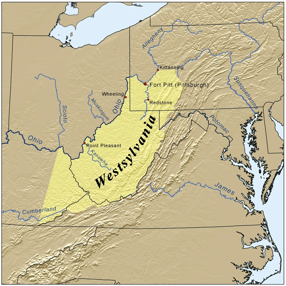
On the map, Westsylvania would have covered most of present-day West Virginia, all of southwestern Pennsylvania including Pittsburgh, slivers of Kentucky and Maryland, and a piece of the Virginia panhandle. Its capital would presumably have been Pittsburgh - the only town in the region with any pretension to urban status in 1776. Its economy would have been driven by river commerce on the Ohio and its tributaries. Its politics would have been dominated by the kind of western-republican populism that, twelve years later, produced the Whiskey Rebellion - a tax revolt in the same geography by many of the same families. West Virginia did finally get its statehood in 1863, on different terms and during a different war. But the idea was already 87 years old by then. Westsylvania has the distinction of being the longest-running unrealized state in American history, and the only one whose advocacy was once a capital crime.
From the Air
The proposed boundaries centered on Pittsburgh and the upper Ohio Valley, extending south through what is now West Virginia. The reference coordinates for this article fall at 38.60 degrees N, 80.80 degrees W in central West Virginia, well within the historical Westsylvania territory. Yeager Airport (KCRW) in Charleston is the nearest major tower-controlled field. Pittsburgh International Airport (KPIT) sits at the historical proposed capital. Recommended viewing altitude 4,500 to 6,500 feet MSL for terrain. Expect ridge-and-valley Appalachian terrain across the historical Westsylvania region; the Ohio River drainage dominates the landscape.
Nearby Stories
- Mount Olive Correctional Complex 9.7 km away
- Nicholas County, West Virginia 11 km away
- Marlinton 12 km away
- Cedar Creek State Park 16 km away
- Burning Springs, West Virginia 17 km away
- Battle of Rich Mountain 19 km away
- Robey Theatre 20 km away
- Cheat Mountain 22 km away