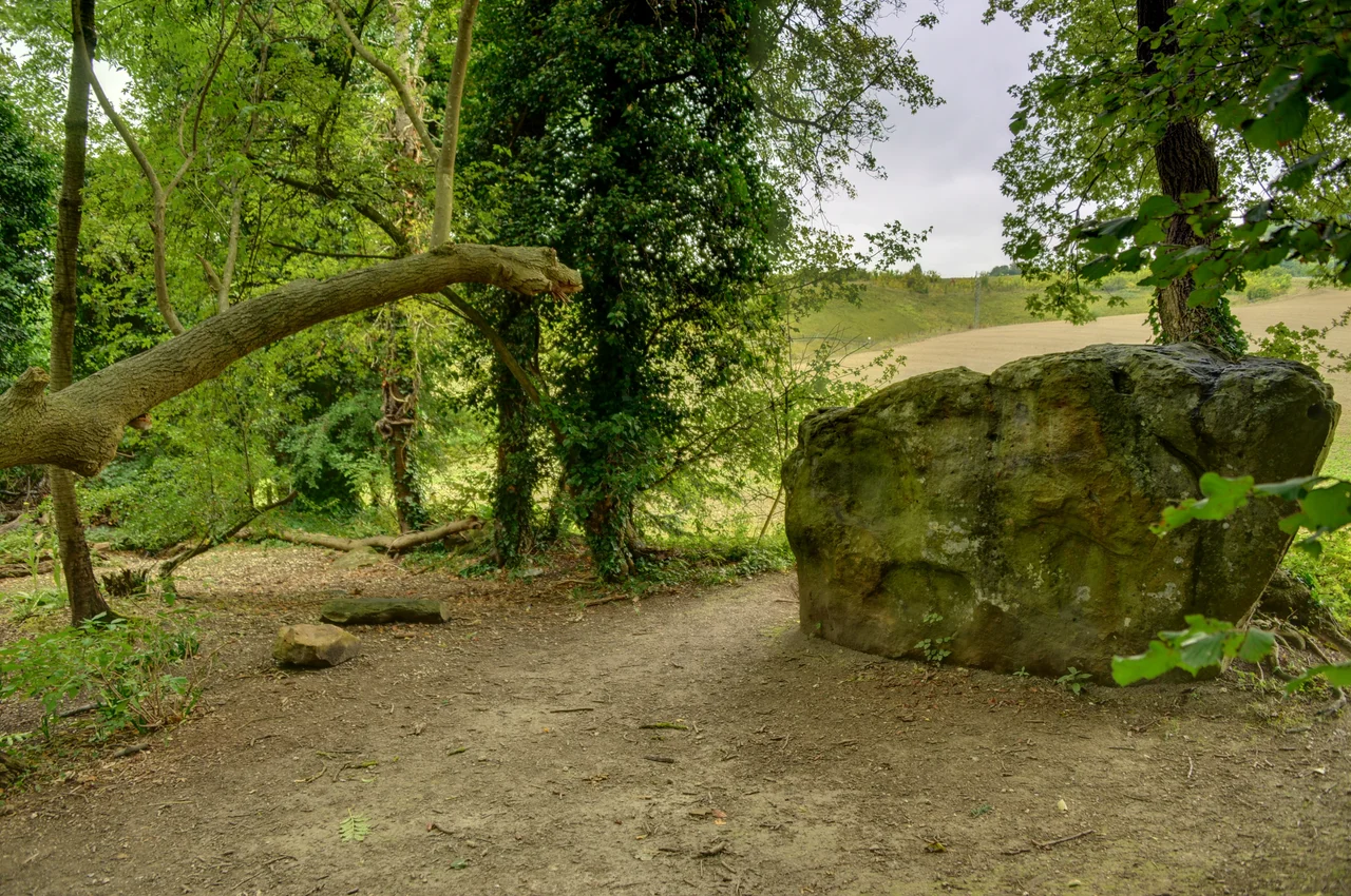

White Horse Stone
There were once two White Horse Stones. The lower one, the original, stood beside the old road from Rochester to Maidstone - the road now called the A229. By 1834, somebody had broken it into pieces and thrown them onto the road. After that, the name and the stories migrated. They settled onto a different sarsen boulder several hundred metres uphill, in a narrow strip of woodland called Westfield Wood, and from then on the upper stone became simply the White Horse Stone. The original is somewhere under the dual carriageway. The successor stands in the trees, scheduled, occasionally vandalised, occasionally garlanded with flowers by modern Pagans who consider it the symbolic birthplace of England.
The Stone and the Wood
The surviving Upper White Horse Stone is a sarsen - a dense, hard, durable sandstone formed from silicified Eocene sand and naturally distributed across the Kent landscape. It measures 2.9 metres long, 1.65 metres high, and about 0.6 metres thick. It sits in Westfield Wood, a narrow strip of trees beside the medieval Pilgrim's Way, which runs along the foot of the North Downs from Winchester to Canterbury. To reach it today you go behind the nearby petrol garage on the A229 and follow the Pilgrim's Way uphill. The stone is scheduled under the Ancient Monuments and Archaeological Areas Act 1979. Nine smaller stones lie scattered westward from it for about ten metres. Whether those smaller stones were part of an original Neolithic structure or were moved there much later by farmers clearing nearby fields, nobody can confirm. Archaeologists have suggested - but never proven - that the White Horse Stone was once part of a chambered long barrow like Coldrum or Kit's Coty House. There is no visible trace of any earthen mound to support this.
The Lower Stone's Long Disappearance
The Lower White Horse Stone once stood about 300 metres west of its replacement, somewhere near where the Pilgrim's Way crossed the Rochester-to-Maidstone road. The archaeologists Brian Philp and Mike Dutto have suggested the precise spot is now buried under the A229 dual carriageway. The antiquarian S.C. Lampreys, writing in his 1834 "A Brief Historical and Descriptive Account of Maidstone and its Environs," recorded that the stone had been "broken into pieces and thrown into the road." Lampreys also noted a local tradition that after the legendary fifth-century Anglo-Saxon invaders Hengest and Horsa fought the British king Vortimer and his brother Catigern, the Saxons' battle standard - a white horse - had been found at the stone. He did not say whether the tradition was true. He simply preserved it. That single passage, written down in 1834, became the source of every subsequent claim that the White Horse Stone was somehow the foundation point of English national identity.
Antiquarian Speculation
In 1842, Douglas Allport included a woodcut of the Lower White Horse Stone in a book about Maidstone. In the mid-1840s the antiquarian Beale Post offered four possible explanations of the name in an unpublished manuscript: that the Saxon battle banner had fallen on the stone after the Battle of Aylesford; that a particular angle of sunlight cast a horse-shaped shadow on it; that Iron Age druids had sacrificed a white horse on it; or that a rider on a white horse had been killed nearby. In 1924, the archaeologist O.G.S. Crawford, working as the first archaeology officer for the Ordnance Survey, listed the Upper White Horse Stone alongside the other Medway Megaliths. By 1927, William Coles Finch's "In Kentish Pilgrimland" included a photograph showing the stone standing alone in open ground. By 1970, when R.F. Jessup photographed it again, trees had grown up around it - the Westfield Wood that surrounds it today. Jessup himself was openly critical of the Anglo-Saxon link, calling stories of the god-like White Horse of Kent attached to the stone "quite without foundation" and "nonsense."
The Excavated Longhouse
Between October 1998 and March 1999, the Oxford Archaeological Unit excavated the area south of the White Horse Stone, ahead of construction work on the Channel Tunnel Rail Link. They found a Neolithic longhouse: eighteen metres long, eight metres wide, of a type known from central and north-western Europe. Radiocarbon dates put it between 4110 and 3530 calibrated BCE - the Early Neolithic, around the time the Medway Megaliths were built. A smaller circular building stood just to the southeast. The longhouse may have been a domestic residence, or it may have been - as the archaeologist Timothy Champion suggested - a more communal and ceremonial building. The excavators offered another possibility: that it was a "house of the living" intentionally placed within sight of the "houses of the dead" up on Blue Bell Hill, including the now-destroyed Smythe's Megalith. The longhouse pre-dates anything in the historical record at this site by about five thousand years. The hill remembers things older than any nation's name.
Modern Pilgrims
Since at least the 1980s, the White Horse Stone has been treated as a sacred site by Heathen religious groups in Britain, particularly the Odinic Rite, founded in 1973. Its co-founder John Yeowell described the stone as "the birthplace of England" and held a blot ceremony there to "reclaim and make holy" the megalith. The Odinic Rite has performed monthly rituals at the stone since 1987 - rites of passage, handfastings, funerals. Yeowell himself, on his death in 2010, had his ashes scattered at the stone. In 1987 the group founded the Guardians of the White Horse Stone to protect the site; they installed timber steps up from the Pilgrim's Way for easier access. They campaigned unsuccessfully against the routing of the Channel Tunnel Rail Link near the stone in the 1990s. In 2003 and again in 2006, working with the related group Woden's Folk, they successfully petitioned Tonbridge and Malling Council to reject a planning application from the telecommunications company Orange to build a radio tower close to the stone. The Odinic Rite emphasises ancestry understood as biological descent, which sets it apart from Druidic groups that work at the same megaliths and understand ancestry in terms of place rather than race. The stone has been vandalised on several occasions; the Guardians have cleaned graffiti off it with methods they believe are not damaging. A single boulder in a small Kentish wood, six thousand years old at the most, carries more contested meaning than its size suggests.
From the Air
Located at 51.315 north, 0.515 east, in Westfield Wood on the lower slopes of Blue Bell Hill near Aylesford, just east of the A229 dual carriageway. London Gatwick (EGKK) is about 22 nautical miles west; Manston (EGMH) is 28 nm east. From the air, the stone itself is invisible under the tree canopy; only the narrow strip of woodland between the M20 motorway and the chalk slope marks the location.
Nearby Stories
- Blackwall Tunnel 0.2 km away
- London Gateway 2.6 km away
- Canterbury Castle 4.2 km away
- Battle Abbey 7.4 km away
- Plymouth Brethren 9.9 km away
- The Carrington Event: The Solar Storm That Could Happen Again 12 km away
- Clacton Pier 32 km away
- 2008 Channel Tunnel fire 42 km away