
Willandra Lakes Region
Roughly 20,000 years ago, a group of people walked across a sheet of wet clay near the edge of a shallow lake - children, teenagers, and adults, some moving fast enough that the prints suggest running. The clay dried, hardened, and was buried. In 2003 the wind uncovered them again: nearly 460 fossilised human footprints, the largest collection of its kind anywhere on Earth, pressed into the floor of a lake that has been dry for millennia. This is the Willandra Lakes Region, a 2,400-square-kilometre expanse of vanished water in the Far West of New South Wales, where the deep history of humanity lies remarkably close to the surface.
Lakes Without Water
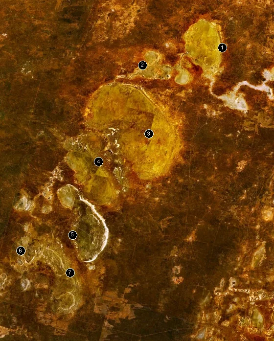
The Willandra lakes once formed a connected chain, fed by an ancient overflow of the Lachlan River system through long-dry Willandra Creek. They filled and emptied across the rhythms of the Ice Ages, and when the climate dried at the end of the Pleistocene, they emptied for good. What remains is a relict landscape of extraordinary clarity: flat lake floors fringed on their eastern shores by crescent-shaped dunes called lunettes, sculpted by the prevailing westerly winds over more than two million years. Among them is the Chibnalwood lunette, the largest clay lunette in the world. The sediments are stacked in three great layers, each a chapter in the story of how the climate and environment of south-eastern Australia changed - and each holding the evidence of the people who lived through it.
A Record of the First People
The Willandra is the traditional meeting place of the Mutthi Mutthi, Ngiyampaa and Paakantyi peoples, and its archaeology demonstrates continuous human occupation for at least 40,000 years. The land is dense with the physical memory of that habitation - hearths where fires were lit, middens of freshwater mussel shell, grindstones, scatters of stone tools, and the burials of ancestors, including those found at Lake Mungo within the region. This is one of the longest continuous records of human life found anywhere on the planet, and it belongs to living communities. The traditionally affiliated Aboriginal people proudly identify with this Country, and they help care for it today as part of the region's joint management.
Where the Earth Kept Notes
The Willandra is so valuable to science that it earned a rare double World Heritage listing in 1981 - recognised for both its cultural significance and its natural and geological importance, one of only a handful of mixed sites in Australia. Locked in its undisturbed Pleistocene sediments is a continuous environmental archive that geologists read like pages. It was here that researchers documented the Mungo Geomagnetic Excursion, one of the most recent known wobbles in the Earth's magnetic field, recorded in the orientation of mineral grains laid down in the ancient lake mud. Few places on Earth combine such an intact natural record with such a deep human one. The lakebeds are, quite literally, a book the planet wrote about itself.
Visiting the Silence
Most of the Willandra remains working pastoral land and Aboriginal Country, with a small protected portion held within Mungo National Park, where the famous Walls of China dunes draw travellers down the long unsealed roads. It is a landscape that rewards stillness rather than spectacle. There are no waterfalls or peaks here - only the enormous horizon, the pale floors of lakes that drained before recorded history, and the sense of standing on ground that human feet have crossed for forty millennia. The fragile fossil footprint site is protected and shown carefully, often through replicas, so that the real prints are not worn away. To grasp Willandra you have to slow down, look closely, and let the scale of the time settle over you.
From the Air
The Willandra Lakes Region covers about 2,400 km² of the Far West of New South Wales, centred near 33.62°S, 143.10°E, at low elevation (around 60-100 m). From the air the defining features are a series of flat, pale dry lakebeds - Mungo, Garnpung, Leaghur, Chibnalwood and others - each edged on its eastern side by a curving lunette dune, with the brightest dunes (the Walls of China) marking Lake Mungo. The terrain is remote and accessed only by unsealed roads. The nearest scheduled-service airport is Mildura Airport (YMIA), roughly 100-120 km to the south. Visibility is generally excellent, with occasional summer dust storms.
Nearby Stories
- Pooncarie 16 km away
- PS Rodney 60 km away
- Mossgiel 63 km away
- Ivanhoe 97 km away
- Kinchega National Park 132 km away
- Warangesda Aboriginal Mission 218 km away
- Echuca 280 km away
- Mount Arapiles 325 km away