Xiluo Bridge
The bridge was half-built when the war took it away. In 1937, the people of rural Yunlin and Changhua counties had pooled their ambitions to span the Zhuoshui River, Taiwan's longest waterway, a braided torrent that had separated communities on either bank for as long as anyone could remember. By 1940, thirty-two piers stood in the riverbed like teeth in an unfinished jaw. Then Pearl Harbor changed everything, the Japanese government seized the bridge materials and shipped them to Hainan, and the Zhuoshui flowed on, uncrossed.
Ambition in the Riverbed
The Zhuoshui River cuts across central Taiwan like a boundary drawn by geology rather than politics. On one side sits Xiluo, a market town in Yunlin County. On the other, Xizhou in Changhua County. Before the bridge, crossing meant ferries, detours, and the constant mercy of water levels. On 24 March 1936, local residents formed a construction committee and pledged the project to the Japanese colonial government. Work began in October 1937, and for three years progress was steady. But Japan's expanding Pacific war demanded materials and labor. The thirty-two completed piers were abandoned, and the steel was requisitioned for military use elsewhere. The river remained a wall.
Cold War Steel
When Taiwan passed from Japanese to Chinese Nationalist control in 1945, the incomplete bridge became unfinished business for a new government. The Xiluo Bridge Reconstruction Committee formed in 1948, but postwar Taiwan lacked the resources to finish alone. In January 1950, a joint survey brought together Taiwan Provincial Government officials, legislators, and engineers from the American Economic Cooperation Administration. The Cold War provided what ambition alone could not: in 1951, the United States contributed US$1.3 million in steel, while the Taiwan Provincial Government added NT$6 million. Construction resumed on 28 May 1952. Seven months later, on Christmas Day, the bridge was complete. The inauguration ceremony took place on 24 January 1953, nearly seventeen years after the original committee first met.
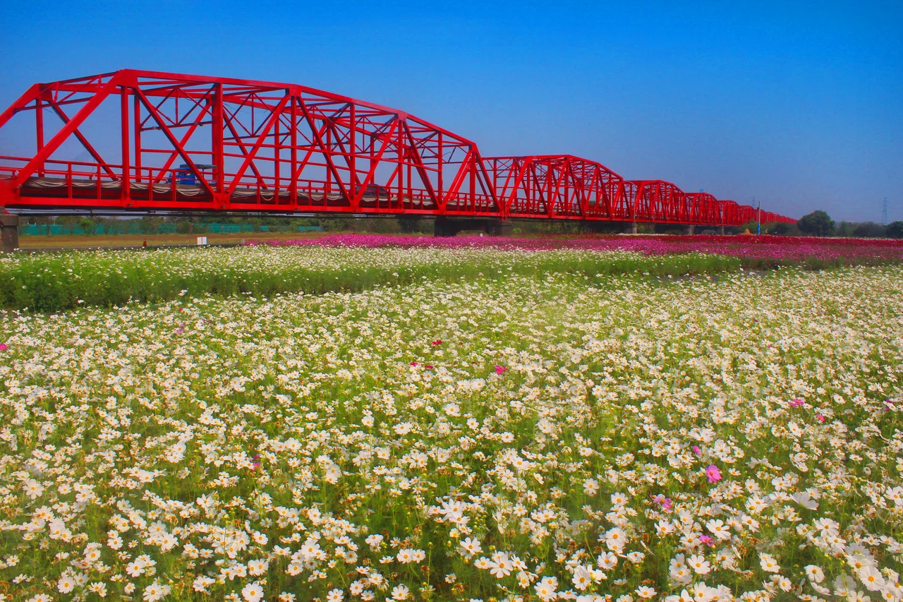
Thirty-One Arches
Stretching 1,939 meters across the Zhuoshui's wide floodplain, the Xiluo Bridge rises in thirty-one gentle arches that give it a rhythmic, almost musical profile from the air. At the time of its completion, it was the longest bridge in East Asia. The Warren truss design, assembled from American-supplied steel by the Taiwan Machinery Manufacturing Corporation, was both functional and elegant, a statement that the island could build infrastructure to rival anything in the region. Today the bridge carries Provincial Highway 1, the traffic mundane but the view from the span still striking: the wide grey-brown ribbon of the Zhuoshui stretching east toward the mountains, rice paddies stretching flat in every other direction.
Spanning More Than Water
The Xiluo Bridge is an artifact of every power that has governed Taiwan in the modern era. Conceived under Japanese rule, abandoned during a world war, resurrected with American money and Chinese Nationalist governance, it carries the fingerprints of colonialism, Cold War geopolitics, and local determination in its very steel. For the farmers and merchants of Yunlin and Changhua, none of that history matters as much as the simple fact that it works. The bridge connects. It replaced ferries with asphalt, turned a geographic barrier into a commute, and made two counties into neighbors rather than strangers across a flood. That was always the point.
From the Air
Located at 23.81°N, 120.46°E, spanning the Zhuoshui River between Xiluo (Yunlin County) and Xizhou (Changhua County) in central-western Taiwan. The bridge is nearly 2 km long with 31 arches, making it clearly visible from altitude as a long linear structure crossing a wide braided river channel. Nearest airports: Taichung International Airport (RCMQ) approximately 40 km to the northeast. Best viewed at 3,000-5,000 ft AGL. The Zhuoshui River floodplain provides excellent contrast for spotting the bridge, especially when the river is low and the wide gravel banks are exposed.
Nearby Stories
- Formosan Aboriginal Culture Village 5.6 km away
- Yushan Weather Station 7.8 km away
- Museum of Old Taiwan Tiles 8.7 km away
- Daodong Tutorial Academy 9.1 km away
- China Airlines Flight 611 28 km away
- Wude Airfield 31 km away
- Hehuanshan 37 km away
- Battle of Xiapi 1155 km away