Xingu Indigenous Park
Orlando and Claudio Villas-Boas walked into the upper Xingu in 1947 with an idea that was heretical for its time: that indigenous peoples did not need to be absorbed, relocated, converted, or civilized. They needed to be left alone, on land that was theirs, and visited only as friends, helpers, and equals. Fourteen years of fighting later, on 14 April 1961, a Brazilian president finally signed a decree that carved 26,420 square kilometers out of Mato Grosso and handed it to the people who had always lived there. It was the first protected territory in the world created solely for indigenous inhabitants, and it would become the template for nearly every indigenous territory in Amazonia that followed.
A Fan of Rivers
At the heart of the park, eight rivers braid together into what will become the Xingu itself. Counter-clockwise from the east, they are the Ferro, the Steinem, the Ronuro, the Jatoba, the Batavi, the Auiiti, the Culiseu, the Culuene, and the Tonguro. In the south, the park still wears the dry open savanna of the Mato Grosso plateau, semi-deciduous and seasonal. In the north, the forest thickens into closed Amazon canopy. Rain falls from November through April, then stops almost entirely. Seen from altitude, the preserve is impossible to miss now, because the land around it is not. Cattle pasture and soy fields press up against the boundary on three sides. The park has become, almost against its designers' hopes, a sharp green island in a beige agricultural sea, a rectangle of intact forest you can trace from space.
A Pre-Columbian Metropolis
The popular story of Amazonia imagines untouched wilderness until the Europeans arrived. The upper Xingu tells a different story. Between roughly 1200 and 1600 CE, this landscape was a densely settled, highly organized anthropogenic system. Villages of a few thousand people each were arranged in pre-planned layouts around circular plazas, ringed by ditches and defensive moats, connected to each neighbor by engineered roads. Each polity controlled about 250 square kilometers of managed forest. The soil itself was a human invention: terra preta, rich black earth built up over generations from charcoal, bone, and organic waste, still fertile centuries later. Archaeologists have now uncovered the remains of 19 such villages in the park and nearby areas. The people we meet today are not the descendants of stone-age survivors. They are the descendants of city builders whose world was dismantled by disease before Europeans ever laid eyes on it.
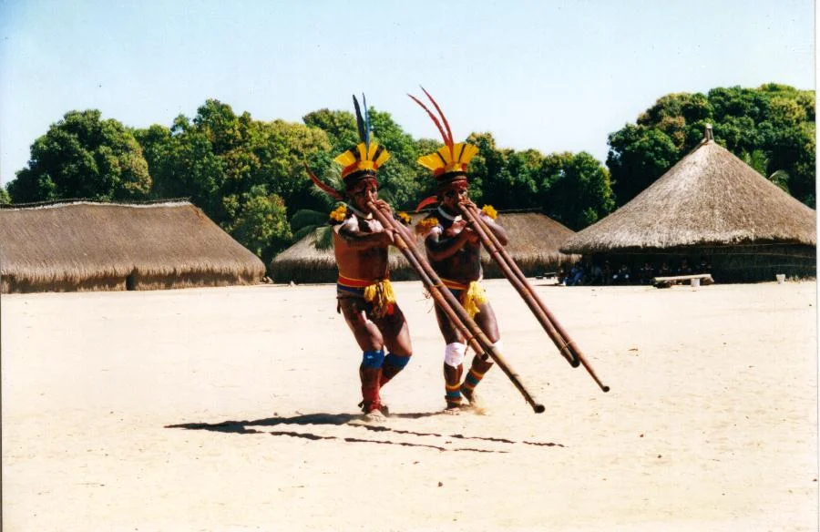
Sixteen Peoples, Fourteen Languages
The park today is home to sixteen peoples whose ancestors arrived at different moments over the past several hundred years, drawn together by the rapids at the Xingu's lower gorges that kept outsiders out. The southern, or Upper Xingu, peoples share a common ceremonial life despite speaking unrelated languages: the Kamaiura and Aweti, whose tongues are Tupian; the Waura, Mehinaku, and Yawalapiti, whose languages are Arawakan; and the Kuikuro, Matipu, Nahukwa, and Kalapalo, who speak Cariban languages. The Trumai language is an isolate, related to nothing else on Earth. To the north live the Kisedje, the Yudja, the Kawaiwete, the Ikpeng, the Tapayuna, and the Naruvotu. Fourteen languages, five language families, fifty villages. The remarkable thing is not their diversity but their coexistence. A single person in many of these villages can speak three or four unrelated tongues, switching freely.
The Ten Years that Made the Park
The Villas-Boas brothers first proposed the park to Brazil's vice president in 1952. Mato Grosso opposed them. The state had already begun selling the land to colonizing companies. Nine bitter years followed, fought in newspapers, in Brasilia hallways, and on the ground where the brothers kept the peace through personal diplomacy alone. The breakthrough came when Janio Quadros, a family friend, became president and pushed the decree through. The territory was shrunk to placate the state, but it was signed. In the sixty years since first contact with the German anthropologist Karl von den Steinen in the 1880s, measles and influenza had cut the Xingu populations by two-thirds. The brothers partnered with Professor Roberto Baruzzi of a Sao Paulo hospital to reverse that. For over fifty years, volunteer medical teams have inoculated and tended the Xingu peoples. The population has rebuilt. Indigenous leaders trained in those years, including Aritana Yawalapiti and Raoni Metuktire, have since spoken on world stages for all of Brazil's indigenous peoples.
Fawcett and the Forest
In June 1925, a British lieutenant colonel named Percy Harrison Fawcett passed through here with his son Jack and a friend named Raleigh Rimell. He spent a few days among the Aweti and Kalapalo, then walked east and vanished. A veteran surveyor who had mapped Bolivia's borders before the First World War, Fawcett had become convinced of a lost city he called Z, an ancient superior civilization hidden in the trees. His disappearance became a media sensation that lasted decades, retold most recently in David Grann's book The Lost City of Z. The irony sharpens over time. Fawcett was looking for a vanished civilization in what turned out to be one of the last places in Brazil that a vanished civilization had actually existed, and where their living descendants were still, in 1925, very much home.
From the Air
Centered near 11.23 S, 53.18 W in northeastern Mato Grosso, Brazil. The park is most visible from FL250-FL350, where its rectangular boundary contrasts sharply with cleared soy and cattle country on every side except the north. Nearest airports are Canarana (SWEK) just outside the southern boundary, Sinop (SWSI) to the west, and the remote Jacareacanga (SBEK) far to the north. The headwaters of the Xingu River rise in the south of the park and fan out across the middle. Expect dry-season haze and smoke from agricultural burning on the park's borders between June and October.
Nearby Stories
- Mato Grosso Tropical Dry Forests 48 km away
- Gol Transportes Aéreos Flight 1907 51 km away
- Varig Flight 254 51 km away
- Percy Fawcett 92 km away
- Serra do Cachimbo 109 km away
- Querência 123 km away
- Sinop, Mato Grosso 203 km away
- Pan Am Flight 202 265 km away