
Yee Wo Street
The name Yee Wo carries more history than the street can hold. It derives from a Qing dynasty trading hong — 怡和 — established in Canton in 1783 by Wǔ Guóyíng, which became the leading firm in the cohong of the Thirteen Factories under the merchant Howqua. Jardine, Matheson & Co. later adopted the same Cantonese name for their operations in Hong Kong, and as one of the largest landowners in East Point from 1841 onward, they effectively stamped it onto the geography. The street's present name dates to no later than 1889. It was renamed Kasuga-dori during the Japanese occupation of Hong Kong, then reverted when the Japanese forces surrendered and withdrew. That history — Chinese origin, colonial rebranding, wartime erasure, restoration — is compressed into two syllables that most people on the street today say without thinking.
Coastline Buried Under Tarmac
Before reclamation, Yee Wo Street followed the natural coastline of Causeway Bay east of East Point. The shore it traced is long gone, pushed outward into Victoria Harbour by successive land reclamation projects across the colonial era. What replaced it is one of the densest pedestrian and transit corridors in Hong Kong. At the western junction where Yee Wo meets Hennessy Road — where East Point Road, Great George Street, Jardine's Bazaar and Jardine's Crescent also converge — the intersection handles some of the heaviest foot traffic in the city. Sogo department store dominates that corner visually, its signage large enough to read from the tram. Over a million people move through the street daily, a figure that becomes more comprehensible when you stand on it during the evening rush and watch the crosswalks fill to capacity on every cycle.
A Circle in the Middle
Built in 1965 and designated footbridge number HF85, the circular pedestrian overpass at the junction of Yee Wo Street, Pennington Street, and Sugar Street has accumulated names the way old places do: Yee Wo Street Footbridge, the Causeway Round Pedestrian Bridge, the Circular Bridge. It has no official name. What it has instead is an appearance in enough films and photographs that it has become a landmark despite being, architecturally, unremarkable — a concrete loop above a busy intersection, offering views in all directions of the traffic it was built to help people avoid. Hong Kong has many such structures, but this one, with its perfect circularity against the vertical backdrop of Causeway Bay skyscrapers, tends to stop cameras. It was constructed the same year the street was taking its current shape, part of the last major widening that gave Yee Wo its modern geometry.
The Trams and Their Terminus
At its eastern end, Yee Wo Street widens into the busy interchange where Causeway Road, Gloucester Road, Irving Street, Leighton Road and Tung Lo Wan Road converge. Here the Hong Kong Tramways maintains its Causeway Bay Terminus — the eastern turning point for tram routes that have operated on Hong Kong Island since 1904. The tram network is one of the few things in this part of the city that has genuinely not changed much: double-decked, slow, cheap, and air-cooled only by open windows, the trams still run on Yee Wo Street as they have for more than a century. Passengers board and alight alongside the buses, the pedestrian crowds, and the taxi queues. The effect is of transportation from three different eras sharing the same piece of tarmac without any of them having obvious priority.
The Street That Became a Protest
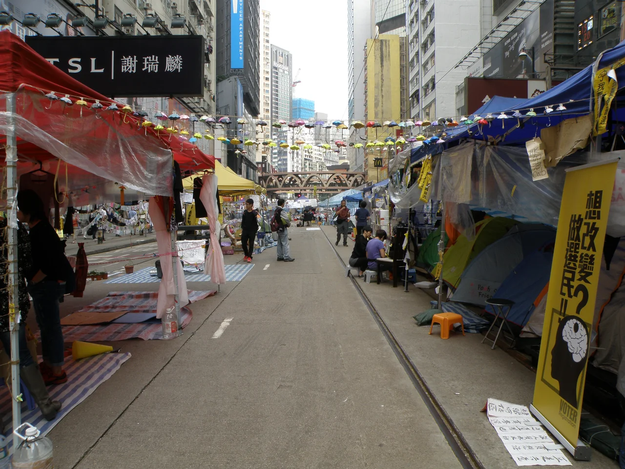
In September 2014, Yee Wo Street and the surrounding area became one of the central occupation zones of what came to be called the Umbrella Revolution — a pro-democracy protest movement during which demonstrators blocked major roads in Causeway Bay, Admiralty, and Mong Kok for weeks. On Yee Wo Street specifically, protesters turned the usually relentless pedestrian corridor into something unrecognisable: tents, supply stations, art installations, hand-lettered signs covering every surface. Tram service along this section was suspended. The occupation lasted 79 days before authorities cleared the sites. What remained afterward was the street itself, resumed in its usual function within hours, as if nothing had interrupted it. The contrast between the street's ordinary capacity to absorb and erase events and the significance of what had happened on it was not lost on those who had been there.
From the Air
Yee Wo Street sits at approximately 22.280°N, 114.186°E on Hong Kong Island, in the Causeway Bay district. At 3,000–5,000 feet approaching from the east, the characteristic density of Causeway Bay's tower blocks is visible, with the typhoon shelter and cross-harbour tunnel approach to the northwest. Hong Kong International Airport (VHHH) lies approximately 18 nautical miles to the west-southwest. The Happy Valley racecourse is visible roughly half a nautical mile to the south. The street itself is too narrow to identify individually from altitude, but the junction area and the Sogo building are recognisable landmarks within the Causeway Bay cluster.
Nearby Stories
- Lok Ma Chau Loop 2.3 km away
- Portas do Cerco 2.3 km away
- Kweilin Incident 17 km away
- Wanshan Archipelago Campaign 34 km away
- Nanxiong Formation 115 km away
- Battle of Nanpeng Island 148 km away
- Heyuan 169 km away
- Cape Maobitou 632 km away