
1861 Eliki Earthquake
The morning of 26 December 1861 began as ordinary mornings do. Then, at 8:28, the ground moved. The earthquake that struck the southern margin of the Gulf of Corinth that morning — magnitude 6.6 to 6.7, the shaking rated destructive on the intensity scale — collapsed buildings on both shores of the Gulf and sent tsunami waves rolling across the water. Up to 20 people died. Another 126 were injured, 18 of them seriously. In the villages along the Achaean coast, families lost their homes to rubble on a December morning, one day after Christmas.
A Coast That Moves
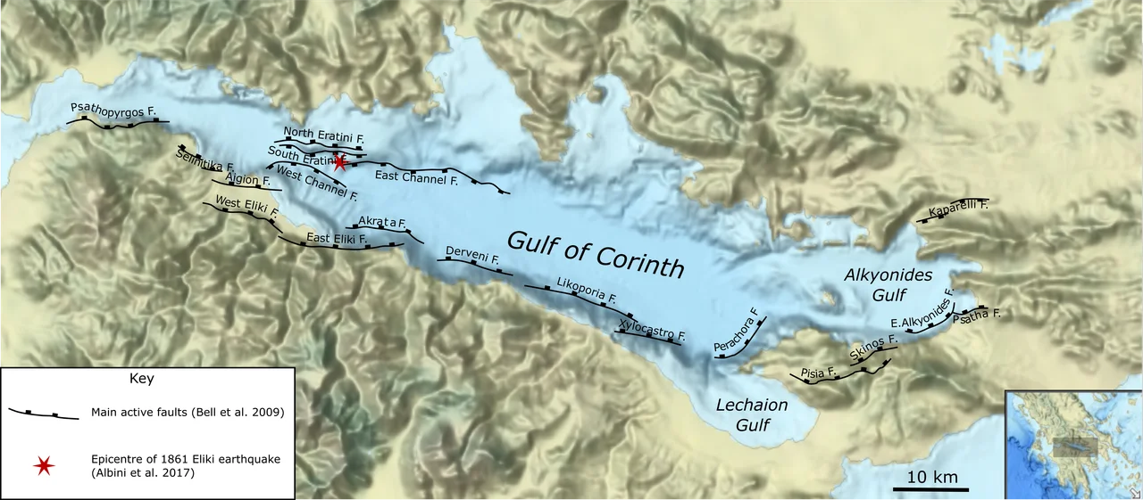
The Gulf of Corinth is one of the most seismically active rifts in Europe. The northern and southern shores are being slowly pulled apart — extending at a rate that, over geological time, is rapid — and the faults that accommodate this movement run along both margins of the water. The Eliki Fault system, which follows the southern shore, is divided into western and eastern segments. The eastern segment is thought to have ruptured in 373 BC, producing an earthquake so violent it drowned the ancient city of Helike beneath the Gulf. The 1861 earthquake ruptured along the same fault system, continuing a sequence of destruction that the coast had been accumulating for millennia.
What the Shaking Left
Damage spread across both sides of the Gulf, from the Achaean towns of the south shore to communities on the northern coast. The maximum intensity of IX — rated 'destructive' on the European macroseismic scale — indicates ground shaking severe enough to cause heavy damage in well-built structures and total collapse in weaker ones. Walls came down. Roofs fell. And then the water moved: a tsunami followed the earthquake, with wave run-ups reaching 2.1 metres along parts of the shoreline. For people living close to the sea, the earthquake itself was only the first danger. The waves that followed gave no warning.
A Scientist Arrives
Johann Friedrich Julius Schmidt, the German-born director of the National Observatory of Athens, surveyed the affected region in the earthquake's aftermath and reported a possible surface rupture — a fissure along the ground 12 to 13 kilometres long that marked where the fault had broken through to the surface. Later geologists have debated whether this fissure represents true surface rupture or the secondary effects of lateral spreading during strong shaking. Either interpretation points to the same conclusion: the earthquake released energy on a scale that left physical scars on the landscape itself. Schmidt's careful mapping made the 1861 earthquake one of the better-documented seismic events in nineteenth-century Greece.
Living with the Fault
The Eliki Fault did not become quieter after 1861. In 1995, the Aigio earthquake struck the same region, damaging the town of Aigio and killing 26 people. The Gulf of Corinth has been subject to continuous scientific monitoring since, with GPS networks, seismographs, and fault trenches tracking the slow, inexorable motion of the rift. The communities along the shore — Aigio, Akrata, the small towns of the Achaean coast — have rebuilt, repeatedly, on ground that will eventually move again. This is not fatalism but geography: this is a coast defined by its faults, and the people who live here have always known it.
From the Air
The 1861 earthquake epicentre was located at approximately 38.28°N, 22.24°E, near the town of Aigio on the southern shore of the Gulf of Corinth. From the air at 5,000–7,000 feet, the Gulf of Corinth is visible as a long, narrow inland sea running east-west, its shores defined by abrupt mountain fronts — the fault scarps that make this landscape so seismically hazardous. The southern shore, where the Eliki Fault system runs, shows the sharp contrast between the coastal plain and the mountains rising behind it. The nearest major airport is LGRX (Araxos), approximately 35 km to the west. Flying east from Araxos along the Gulf, the town of Aigio is visible on the southern shore, backed by the high ridges of the northern Peloponnese.
Nearby Stories
- Battle of Chaeronea (86 BC) 1.2 km away
- Mycenaean Cemetery of Voudeni 2.7 km away
- Battle of Lechaeum 4.8 km away
- Amfissa 5.5 km away
- Pheneus 6.3 km away
- 1981 Gulf of Corinth Earthquakes 7.3 km away
- Thermos (Aetolia) 13 km away
- Battle of Lalas 30 km away