
1996 Pat Sin Leng Wildfire
The Hong Kong Observatory had issued a Red Fire Danger Warning that Saturday morning, February 10, 1996. Relative humidity had dropped to 31 percent. Forty-nine students from HKCWC Fung Yiu King Memorial Secondary School were already on the trails of Pat Sin Leng — the Range of the Eight Immortals — following sections 9 and 10 of the Wilson Trail toward Fanling, as part of a geography club hike linked to the Duke of Edinburgh Award Scheme. The fire found them near Hsien Ku Fung, roughly 150 meters from a rock formation locals call Ma Lau Ai — Monkey Cliff. What happened next became the worst wildfire in Hong Kong's recorded history.
The Fire Comes Uphill
Wildfires in steep terrain behave in ways that can defy instinct. They travel faster uphill than down, pushed by heat and draft, and on a hillside with 31 percent humidity in February, the dry grass burns with little resistance. When the group spotted the fire at around 11:20 a.m., their downhill route was already cut off. Thirty-two students managed to escape to safety and raised the alarm. But eighteen people — students and teachers — found themselves trapped against the near-vertical rock face of Monkey Cliff, with no way down and the fire closing in below. Teachers Chow Chi-Tsai and Wong Shuo Mei stayed with the students who couldn't climb or descend on their own. They did not survive. Three students also died — one in the immediate aftermath, others later from burns sustained on the cliff.
Rescue on the Ridge
The search-and-rescue operation launched at 12:23 p.m., bringing more than 200 firefighters, Agriculture and Fisheries Department staff, and Civil Aid Service volunteers to one of the more difficult terrain features in the New Territories. The Government Flying Service sent two helicopters, which were crucial both for fighting the fire and for evacuating the most critically injured — including one student who had suffered burns over 70 percent of her body and was rushed directly to intensive care. Getting rescuers and survivors down from Monkey Cliff without road access, through smoke and on steep hillside, tested every element of the emergency response. The fire burned for more than 40 hours before it was fully extinguished the following morning. Twenty hectares of hillside vegetation were destroyed; the area suffered soil erosion in the months that followed before the vegetation slowly returned.
A Rescue Complicated by Smoke
One of the helicopter rescue attempts went wrong in a way that cost precious time. A Government Flying Service crew, using a winch sling, located two casualties on the hillside. They attached a safety harness in line with their code of practice and began to lift — but the pilot, his visibility obscured by smoke, could not see clearly whether the casualties were properly secured. As the helicopter climbed, the rescuer came up; the casualties did not. A second attempt encountered the same confusion about who had been recovered and who had not. The final missing person was found the following day, and was confirmed to be one of the victims from those failed winch attempts. The episode illustrated, grimly, how even a well-intentioned and practiced rescue operation can be complicated by conditions that no training fully anticipates.
What the Inquest Found
The Coroner's Court heard the case in May 1996. The coroner concluded that the fire was most likely started by students smoking — a finding that added weight to the question of supervision. The teacher-to-student ratio that day was one to twelve, below the recommended standard of one to ten. None of the teachers carried appropriate communications equipment. Separately, critics raised the issue of hospital transfer protocols: ambulances were required to bring patients to the nearest emergency department first before any transfer to a better-equipped facility, which added four kilometers to the journey for some of the most seriously burned survivors. The Tai Po Jockey Club Clinic — the only medical center in Tai Po at the time — was not equipped to manage a mass casualty event. The government's emergency coordination center was not operational during the incident, and the response, while large, suffered from this absence of central coordination.
Spring Breeze Pavilion
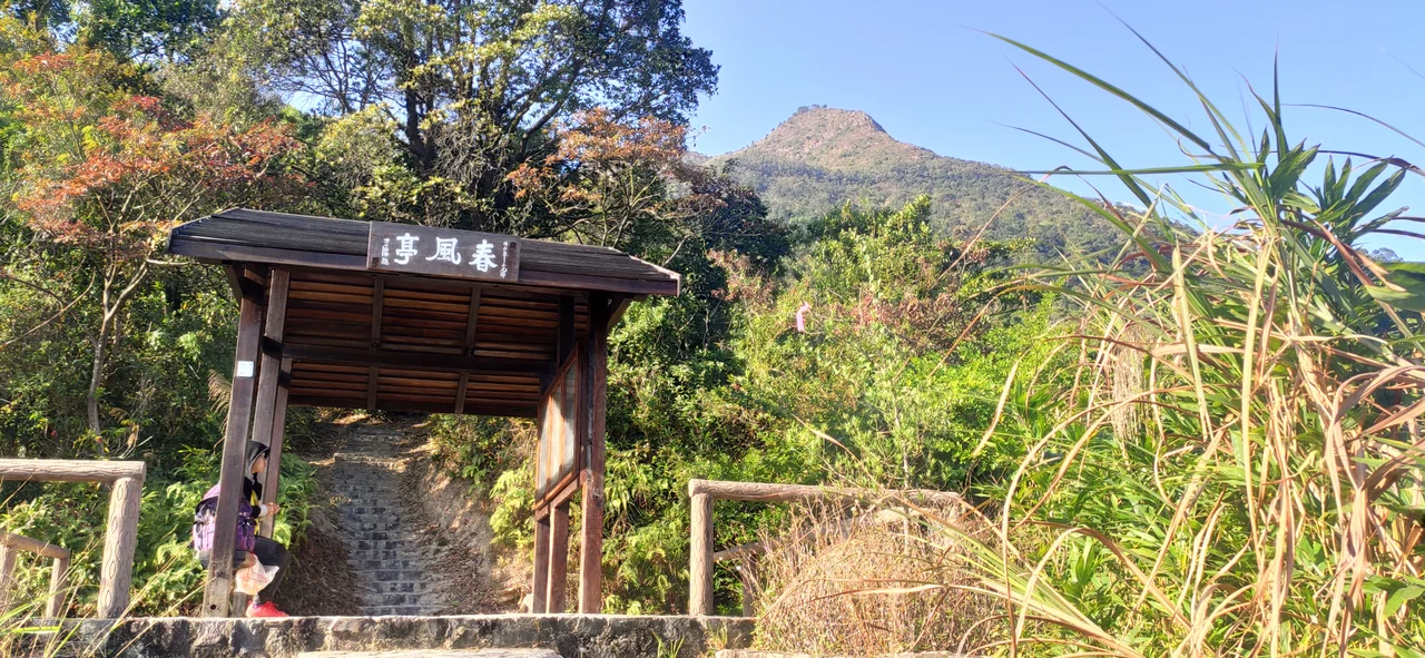
On the ridge of Pat Sin Leng, the Hong Kong Government erected a pavilion in memory of teachers Chow Chi-Tsai and Wong Shuo Mei — the Spring Breeze Pavilion, whose name evokes the image of a gentle wind carrying comfort. It stands at the spot where two people chose not to leave their students. A hiker named Tam Ka-Fat, who helped evacuate four students from the fire (two of whom later died from their injuries), died by suicide in July 1996, five months after the event. His death, by immolation, was attributed to suspected post-traumatic stress. The pavilion remains. In the years since, the vegetation has grown back across the twenty burned hectares, and Pat Sin Leng is again a popular hiking destination — but those who know its history understand that the views from the ridge came at a cost.
From the Air
Pat Sin Leng sits at approximately 22.4835°N, 114.216°E in the northeastern New Territories, north of Plover Cove Reservoir. The range is visible from moderate altitude as a prominent east-west ridgeline rising to around 639 meters at Hsien Ku Fung. Approaching from the south or east, the reservoir's deep blue contrasts with the green hillsides. The nearest international airport is Hong Kong International (VHHH), approximately 50 kilometers to the southwest. Small general aviation facilities at Shek Kong (VHSK) lie roughly 20 kilometers to the west.
Nearby Stories
- Chapel of St. Francis Xavier 3.5 km away
- Cuiheng 4.1 km away
- 2015 Shenzhen Landslide 16 km away
- Shunde 31 km away
- Wanshan Archipelago 37 km away
- Nanxiong Formation 96 km away
- Heyuan 149 km away
- Checheng Fu'an Temple 629 km away