.jpg)
2007 Solomon Islands Earthquake
At 7:39 in the morning on 2 April 2007, the seafloor off Gizo lurched. The Australia plate ground under the Pacific plate along a 250-kilometer stretch of the Solomon arc that had been quiet for a century, and the ground across Ghizo Island began to shake. The S-waves gave the warning. People who had felt earthquakes before knew what came next. Across the villages of the New Georgia Group, men and women grabbed children and ran - up the slopes, into the bush, away from the shore. Twenty minutes later the first wave arrived. Twelve meters high on Simbo, ten meters high at Choiseul, it washed away thirteen villages and killed fifty-two people. The survivors who ran uphill lived. Those who did not, mostly did not.
The Quake
The focus was shallow - ten kilometers deep - and forty kilometers south-southeast of Gizo township. The U.S. Geological Survey registered the magnitude at 8.1; other scales put it at 7.8. The quake was what geologists call a megathrust: the Australia, Woodlark, and Solomon Sea plates pushing northeast under the Pacific plate, the classic subduction geometry that built the Solomon arc in the first place and keeps building it, one earthquake at a time. What made the 2007 rupture notable was its location. The segment that failed had not produced a magnitude-7-or-greater shock since the early twentieth century - a quiet stretch that had been accumulating stress for a hundred years. When it finally let go, it let go all at once, faulting along a length of about 260 kilometers beneath the seafloor.
The Warning That Did Not Come
The Pacific Tsunami Warning Center, headquartered in Hawaii, exists to send alerts across the ocean basin when a quake of this size fires off. Against a tsunami moving at twenty-five meters per second, the center had perhaps fifteen minutes to work with - and the wave closed the fifty-five kilometers from the epicenter to Gizo in less than twenty. For the villages of the Western Solomons, the only warning was the shaking itself, and the knowledge - passed down through generations of islanders who live on a subduction zone - that a strong quake meant high ground, now. The first call for help went out not through any official channel but over high-frequency radio. Nickson Sioni, sitting at a village email station on Simbo Island run by the People First Network, came on the air twenty minutes after the quake to report that a huge wave had struck the village, washed away houses, and come two hundred meters inland. That call, relayed to Honiara and from there to Hawaii, upgraded the tsunami warning to a regional alert - just in time for Honiara, which the wave reached non-destructively.
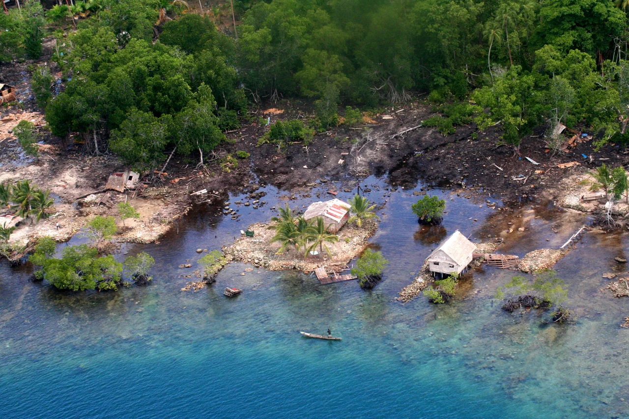
Simbo and Choiseul
The highest run-ups were recorded at the northern tip of Simbo, where the water reached twelve meters above normal sea level and erased two villages, Tapurai and Riquru, entirely. Ten people died on Simbo. In South Choiseul, ten-meter waves swept across the coastal plain, destroying villages, gardens, and a hospital. The death toll across the affected islands reached fifty-two by the time records were compiled, with sixty more reported missing. About nine hundred homes were destroyed. Thousands were displaced, and many villages were so remote that relief supplies did not reach them for days. The tsunami traveled far enough to put a family of five missing from a remote island in Milne Bay Province in Papua New Guinea. Beach closures and tsunami alerts reached as far as Sydney. Most of the dead were people who lived in the kind of places a visitor never reaches - low-lying coastal villages on islands with no road, no airstrip, and no way to transmit a warning faster than the wave could travel.
Ranongga Rises
When the ground stopped moving, the island of Ranongga - in the New Georgia Group north of Gizo - was three meters higher than it had been that morning. Its beaches had extended outward by as much as seventy meters. Large sections of fringing reef, colonies of coral that had been under water for centuries, were suddenly above the tideline and dying. Local fishermen stared at the changed coastline and worried that their grounds had been destroyed. Australian scientists who arrived afterward had a different view: this was island building, the same mechanism that had raised the Solomons out of the sea in the first place, operating in human time rather than geological. Careful management, they argued, could preserve the reefs that remained below water and the island would absorb the loss of those above. For the fishermen, that was cold comfort. The reef they knew was gone.
Aftermath and Warning Buoys
Relief came from across the Pacific. Australia committed $5.7 million over the first months, New Zealand $7.5 million over two years, the United States $250,000, Taiwan $214,000 plus a thousand kilograms of rice, France airlifted supplies through New Caledonia. Papua New Guinea, itself struck by the tsunami, sent $340,000 and a light plane small enough to reach airstrips where larger aircraft could not land. UNICEF appealed for half a million dollars, the Red Cross for eight hundred thousand. A Taiwanese fishing boat carrying aid ran aground on a reef; a U.S. Navy helicopter evacuated the crew, and the boat was freed days later. On Simbo, where ten people had died, the MP Francis Billy Hilly observed on 8 April that villagers who had previously resisted relocation away from the island's active volcano were now reconsidering. The Australian government announced a new network of five tsunami warning buoys along its Pacific coast, two of them positioned in the PNG-Solomons area - an effort to make sure that the next time the Solomon arc shifted, the wave did not arrive unannounced.
From the Air
The epicenter was at approximately 8.48 degrees South, 156.98 degrees East, in the Solomon Sea just south of Ghizo Island in the New Georgia Group. Nusatupe Airport (AGGN) at Gizo is the main airfield for the Western Province. Munda Airport (AGGM) and Honiara's Henderson Field (AGGH) serve as regional alternatives. From above, the uplifted coastline of Ranongga remains visible as a pale band of exposed reef flat - a permanent geological signature of the 2007 event. Weather in the region can deteriorate quickly during the November-April wet season; plan fuel reserves accordingly.
Nearby Stories
- Battle of Arundel Island 19 km away
- Battle of Vella Lavella (naval) 88 km away
- Battle of the Treasury Islands 160 km away
- Woodlark Island 405 km away
- Misima Island 508 km away
- Païta 1761 km away
- Maré Island 1826 km away
- 1737 Kamchatka Earthquake 6759 km away