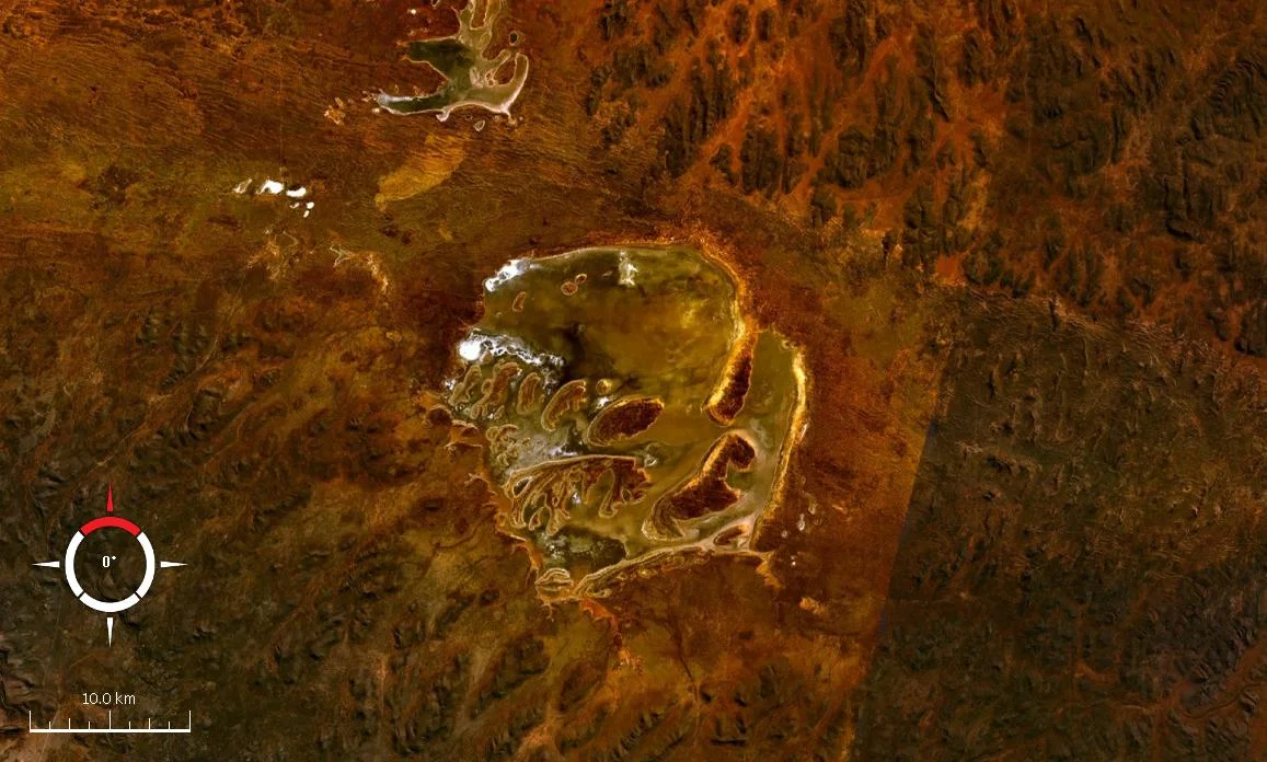

Acraman Impact Structure
From the air it looks almost gentle: a pale, near-circular smear of salt pan and low islands set into the rust-red scrub of the Gawler Ranges, about 20 kilometres across. Lake Acraman is an ephemeral playa, dry for most of the year, easy to fly over without a second glance. Yet this faint ring is the scar of one of the largest meteorite impacts known on the Australian continent. Roughly 580 million years ago, in the deep Precambrian, an asteroid slammed into what was then ancient bedrock, blasting out a crater that may have measured close to 90 kilometres across before hundreds of millions of years of erosion ground it down to almost nothing.
Reading a Crater That Barely Exists
Most famous impact craters announce themselves with a rim and a bowl. Acraman does the opposite. It is so deeply eroded that its true size has to be reconstructed by indirect means, and geologists still argue over the numbers. Some estimate an original collapse crater up to 85 to 90 kilometres in diameter, with a transient cavity around 40 kilometres wide at the moment of impact; others favour a smaller structure, closer to the present depression that cradles the lake. The larger figure implies an almost unimaginable release of energy, on the order of five million megatons of TNT. The most direct fingerprints survive on the islands within the lake, where shattered bedrock preserves shatter cones and grains of shocked quartz, the telltale minerals that form only under the colossal pressures of a hypervelocity strike.
The Debris That Travelled East
The most remarkable evidence of Acraman lies not at the crater but more than 300 kilometres away, in the layered red rock of the Flinders Ranges. There, threaded through the Ediacaran shales of the Bunyeroo Formation and exposed in gorges such as Brachina, runs a distinct band of ejecta: fragments of volcanic rock flung from the impact site, identical in age and composition to the bedrock at Lake Acraman. When the asteroid struck, this whole region lay beneath a shallow sea, and the debris rained down and settled into the soft seafloor mud. Drill holes far to the north, in the Officer Basin, have found the same horizon. Few places on Earth let you stand at a crater and then drive a few hours to touch the dust it threw.
A Blast and the Dawn of Animal Life
Acraman's timing places it at a fascinating moment in the history of life. The impact debris in the Flinders Ranges sits within Ediacaran rocks, close to the very region that gives its name to the Ediacara biota, the strange soft-bodied creatures that represent some of the earliest complex animals known. Just above the ejecta layer, scientists have documented a burst of diversity among microscopic marine organisms called acritarchs, and some researchers wonder whether the two events are linked. The connection remains debated rather than proven; the crater's nearness to the cradle of early animal life may simply be coincidence, especially given that an impact this size would have had consequences felt across the entire planet. But the question itself is irresistible, a hint that a single violent afternoon may have rippled through the unfolding story of life.
Named, Discovered, Remembered
The structure carried its secret quietly until 1986, when geologists George E. Williams and Victor A. Gostin reported the discovery, and the independent recognition of its ejecta, in the journal Science. The lake, the impact structure, and nearby Acraman Creek all take their name from John Acraman, a South Australian colonial businessman, though the man long predates any knowledge of what lay beneath the salt. Today the site sits within a remote, sparsely peopled stretch of the Gawler bioregion, recognised on the South Australian Heritage Register. There is no visitor centre, no marked rim to walk; the crater keeps its scale hidden in plain sight, legible only to those who know what the pale ring once was.
From the Air
Lake Acraman sits at roughly 32.02 degrees south, 135.45 degrees east, in the Gawler Ranges of remote western South Australia. From altitude the near-circular playa, about 20 kilometres across, reads as a pale ring among the surrounding red-brown ranges and the larger white salt sheets of Lake Gairdner and Lake Everard to the north and west, all of which make excellent visual landmarks. This is genuinely isolated country with very limited infrastructure; the nearest controlled facilities of note are Port Augusta Airport (YPAG) far to the east and Ceduna Airport (YCDU) to the south on the coast, both well over 200 kilometres distant, so flight planning should account for sparse fuel and services. Best viewing is in clear, dry conditions with low sun, which deepens the contrast between salt, water (when present), and surrounding rock.
Nearby Stories
- Poochera, South Australia 44 km away
- Streaky Bay, South Australia 109 km away
- Wilgena Station 118 km away
- Port Kenny 121 km away
- Tarcoola railway station 153 km away
- Port Augusta 162 km away
- Olympic Dam mine 171 km away
- Pichi Richi Railway 189 km away