Admiralty Islands
Forty thousand years ago, before agriculture and before written language, people were trading obsidian across this archipelago. The volcanic glass came from a few specific outcrops and moved between islands by canoe. The same early inhabitants brought wild bandicoots and large rats across the water with them, presumably as food, and cultivated taro in gardens we can still identify archaeologically. These were not castaways. They were a society, running a trade network that predated most of what humanity considers its own oldest history. The forty islands that make up the Admiralty chain have been doing this - hosting civilizations, connecting cultures, keeping secrets - for longer than almost anywhere else on Earth.
The Shape of the Archipelago
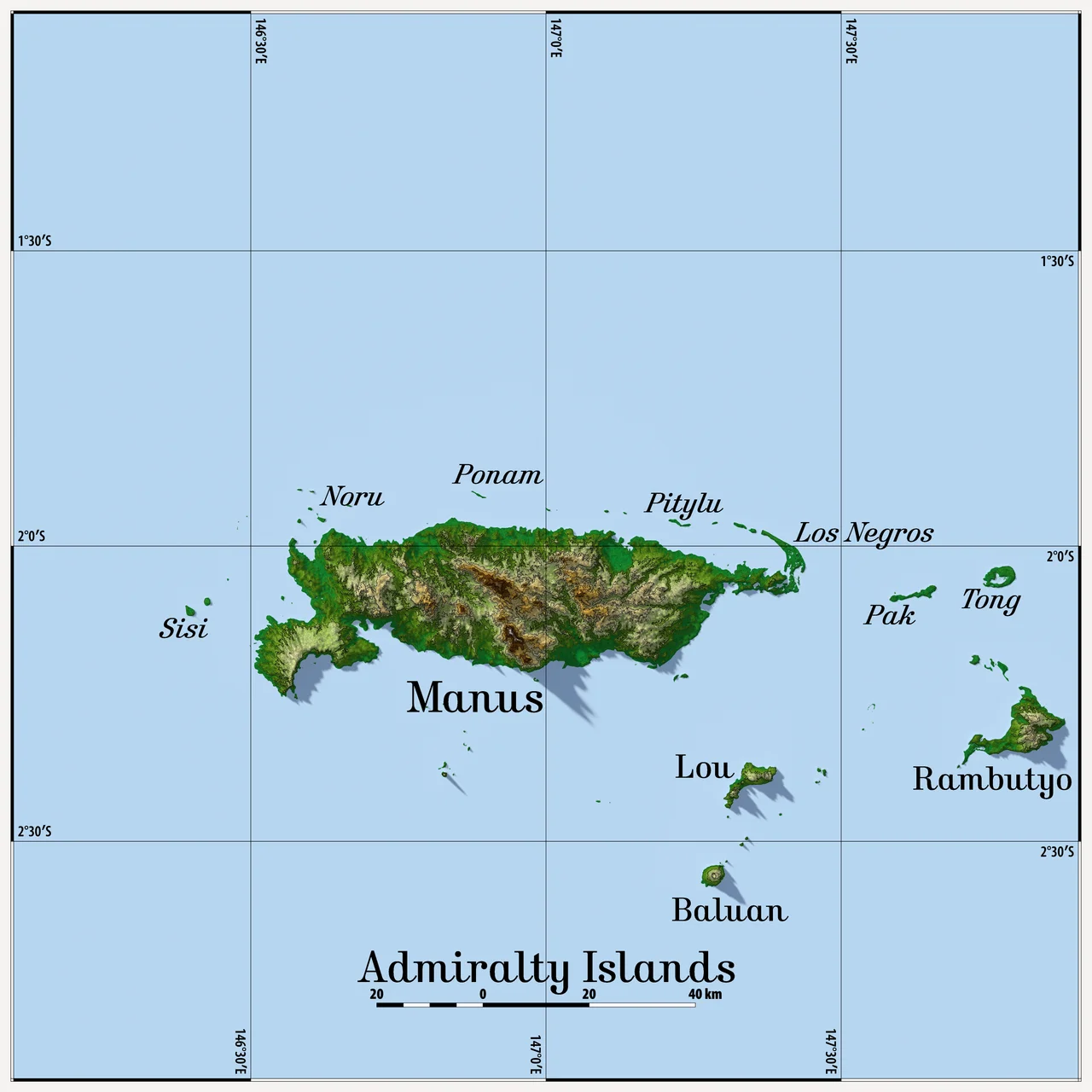
The Admiralty Islands sit in the Bismarck Archipelago, north of New Guinea, and together they form Manus Province - the smallest and least-populous province of Papua New Guinea. At the 2011 census the province had a population of 60,485 people, scattered across forty islands, many of which are uninhabited atolls. Manus Island is the giant of the group and gives the province its name. To its east sit Tong, Pak, Rambutyo, and Lou; to the south Mbuke and Baluan (the main island of the Pam group, where the Baluan-Pam language is spoken); to the west Bipi. Ndrova, Pityilu, and Ponam carry their own histories. The whole archipelago covers little ground, but the water between the islands is the connective tissue of everything here.
Eight Million Years Up
Manus Island, the cornerstone of the chain, is volcanic in origin. It broke through the ocean's surface in the late Miocene, somewhere between eight and ten million years ago, and what we walk on today is either direct volcanic substrate or uplifted coral limestone - ancient reefs raised into the air by slow tectonic forces. The temperature barely changes. Daily highs and nightly lows are the same month after month. Rainfall is heavy and slightly seasonal, peaking from June to August. Manus reaches modest elevation at Mount Dremsel, 718 meters above sea level near the center of the south coast. The island's shape - jungled, hot, deeply rivered - is the product of a volcano slowly weathering under equatorial rain for several million years.
Endemic Life
Isolation produces evolution. The rain forests of the Admiralty Islands are considered their own ecoregion, the Admiralty Islands lowland rain forests, and they shelter species found nowhere else. Three endemic bird species are listed as vulnerable on the IUCN Red List: the Manus fantail, the superb pitta, and the Manus masked owl. The Manus dwarf kingfisher is near threatened. Other endemic birds - the white-naped friarbird, the Manus monarch, the Manus hawk owl - remain more common. Endemic mammals include the Admiralty Island cuscus, a mosaic-tailed rat, several fruit bats, and a sheathtail-bat. The emerald green snail of Manus was the first terrestrial snail ever listed as vulnerable by the IUCN, hunted for decades because its shell was turned into jewelry. The Ndrolowa Wildlife Management Area, established in March 1985 south of Lorengau, protects a piece of this living museum.
Names on the Map
Europeans arrived late. The Spanish explorer Alvaro de Saavedra circled Manus in 1528 on his way home from the Maluku Islands and charted it as Urays la Grande - probably a projection of a local islet name, Murai. The Dutch navigator Willem Schouten reported sighting the islands in 1616. It was the British captain Philip Carteret, in 1767, who gave the archipelago the name it carries today - Admiralty Islands, after the British Royal Navy's governing body. Germany administered the group as a colony from 1884 to 1914, until Australian forces arrived on the SS Siar in November 1914 and fired what were literally the last shots of the Bismarck Archipelago campaign - a brief machine-gun burst over the heads of a tiny German garrison at Lorengau. The islands then came under Australian mandate.
Operation Brewer
Japanese forces took Manus on April 7, 1942, early in the Pacific War. They built airfields and held the island for nearly two years. In February 1944, American forces launched Operation Brewer - the Admiralty Islands campaign - and defeated the Japanese garrison in a matter of weeks. What followed was the transformation of the archipelago into one of the largest Allied forward bases in the Pacific: the American airbase and Manus Naval Base at Lombrum, near Lorengau, became a staging ground for the push toward the Philippines and Japan. When the war ended, the bases were largely dismantled. The Admiralty Islands became part of Papua New Guinea at independence in 1975, organized as Manus Province of the Islands Region. Today there is little tourism. The reefs attract divers - Jean-Michel Cousteau spent time on nearby Wuvulu Island in the 1970s - but mostly the islands are quiet, and the jungle is taking the old runways back.
From the Air
The Admiralty Islands center near 2.1 degrees south, 146.95 degrees east, roughly 300 kilometers north of mainland New Guinea. Momote Airport (AYMO) on Los Negros Island serves the archipelago via a road bridge to Manus Island and the provincial capital Lorengau. The islands are deep-water surrounded, which historically made Seeadler Harbor one of the best anchorages in the western Pacific. Terrain is modest - Mount Dremsel at 718 meters is the highest point - and fields of rainforest, atolls, and reefs make for excellent visual flying in clear weather. Expect afternoon convective buildups, especially June through August.
Nearby Stories
- USS Mount Hood (AE-11) 5.6 km away
- Manam Motu 241 km away
- Karkar Island 276 km away
- Sepik 278 km away
- Landing on Emirau 300 km away
- New Hanover Island 328 km away
- Battle of Lone Tree Hill 827 km away
- Mamberamo River 987 km away