
Andravida
Nobody knows exactly what the name means. The most plausible theory is that it comes from a Slavic word for 'place of the otters' — which would make Andravida one of the few medieval Frankish capitals named after a semi-aquatic rodent. The Franks called it Andreville. The Aragonese said Andrevilla. Whatever the name's origin, by the thirteenth century this unfortified market town in the flat plains of northwestern Elis had become the seat of the Principality of Achaea, the most powerful Crusader state on the Greek mainland. Today a ruined Gothic cathedral stands near the center of town, and almost nothing else of the Frankish centuries remains.
Why the Crusaders Chose This Spot
When William of Champlitte led his Crusader force through the Peloponnese in 1205, the towns of the western coast fell without a fight. At Andravida, the local Greek magnates — lords of Elis and of the mountain districts of Skorta and Mesarea — gathered and paid him homage, acknowledging him as their overlord. According to the Chronicle of the Morea, the transfer of power here was peaceful, practical, political. The Franks recognized what the Greeks already knew: Andravida's position was excellent. Situated in the fertile plain of Elis, well provisioned and capable of supporting horses, close enough to the port of Glarentza for trade and supply but not on the coast and therefore safe from seaborne raids, equally distant from the restive mountain populations of the interior — it was a capital that required no walls because its geography was its defense. It was never fortified.
A Capital of Cathedrals
The Frankish Principality of Achaea was one of the successor states carved out after the Fourth Crusade fragmented the Byzantine Empire, and Andravida served as its de facto capital through the thirteenth century. The town filled with the institutions that power requires. A palace for the Princes. The Church of Saint Stephen, likely belonging to the Franciscans. The Church and hospice of Saint James, granted to the Teutonic Order in 1241 and used as the burial site for the ruling House of Villehardouin. A convent of Saint Nicholas of Carmel. And the largest of all: the Church of Saint Sophia, serviced by the Dominican Order, grand enough to host the assemblies and parliaments of the principality's nobility. The town also became the seat of a Roman Catholic bishopric from 1212, absorbing and renaming the older Greek bishopric of Olena. When early nineteenth-century travelers François Pouqueville and Jean Alexandre Buchon passed through, three of the Frankish churches were still largely standing. Today, only the ruins of Saint Sophia survive to any substantial extent.
The Gothic Ruin at the Town's Heart
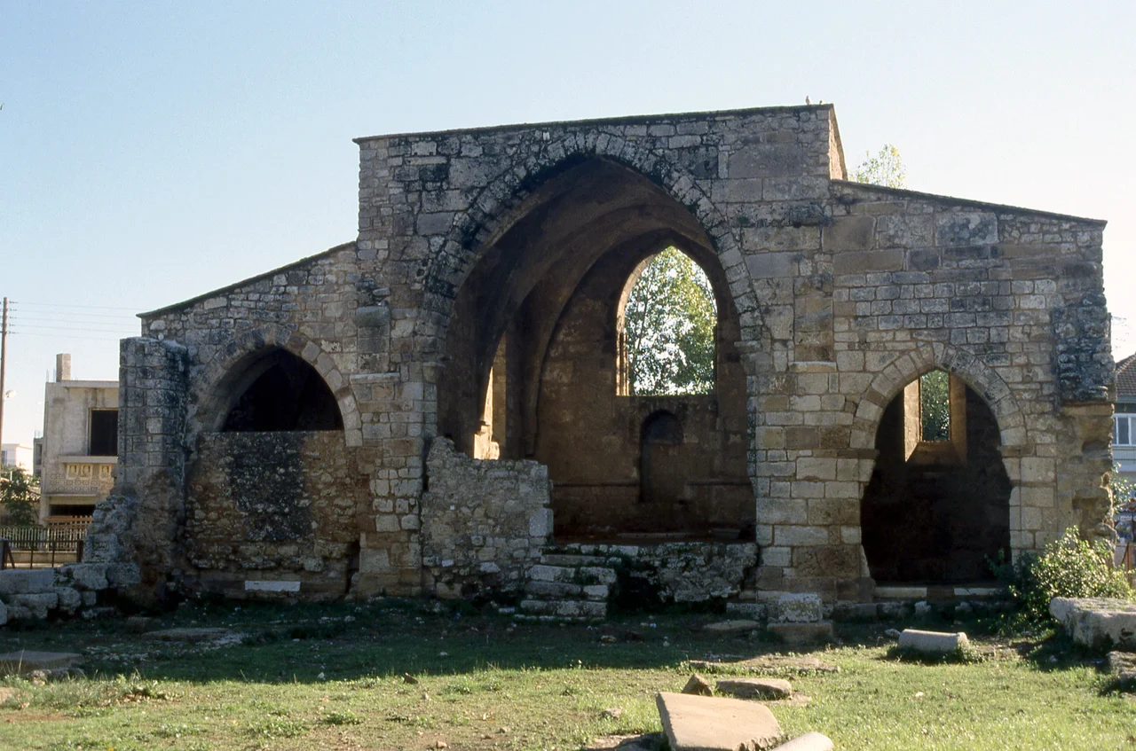
Agia Sofia — Saint Sophia — is what remains of the Dominican church, and its Gothic arches still stand among the modern buildings of Andravida with an incongruity that the flat plains of Elis do nothing to soften. Gothic architecture in the Peloponnese is already unexpected; the ruins of a Gothic cathedral in what is now a small agricultural town of roughly 3,700 people are more unexpected still. The arches are of the Western European Gothic tradition brought by the Crusaders — pointed, elegant, built to echo cathedrals the Frankish nobles had left behind in France and the Low Countries. For a century and a half, this was the principal church of a state that styled itself on the chivalric model of western feudalism. Then power shifted.
The Principality's Long Decline
Andravida outlasted the Principality that made it important. In the late 1420s the Despotate of the Morea — the Byzantine successor state in the southern Peloponnese — absorbed Elis and Achaea. The Ottoman Empire conquered the region in 1460. A brief Venetian interlude ran from 1686 to 1715. Then Ottoman rule resumed until Greek independence. The town persisted through all of this without walls, without a citadel, without strategic importance — it survived on the same advantages that had made the Franks choose it in the first place: good land, a central position, access to the plains. The fighter Konstantinos Andravidiotis, who took his surname from the town, served in the Greek War of Independence; his name is one of the few human traces left from those centuries of transition. The Gothic arches of Saint Sophia stood through all of it, slowly losing their roof, slowly losing their walls, slowly becoming the ruin they are now.
From the Air
Andravida lies at 37.906°N, 21.267°E in the flat agricultural plains of northwestern Elis, about 7 km from the Ionian coast. From the air, the plains around Andravida are immediately recognizable: level, cultivated, with none of the topographic drama of the surrounding regions. The Andravida Air Base (Hellenic Air Force) is 2.5 km east of town and visible from altitude; its runways serve as the clearest orientation landmark. Nearest civilian major airport is LGRX (Araxos), approximately 25 km to the north-northeast — the closest of the five sites in this group to Araxos. Approach from the Ionian coast heading east; the plains resolve into the town center with the medieval ruin of Agia Sofia visible from low altitude as a distinctive Gothic outline among modern structures.
Nearby Stories
- Astras 4.5 km away
- Heraea (Arcadia) 5.3 km away
- Battle of Lepanto 6.7 km away
- Ionian Islands 9.7 km away
- Saint Gerasimos Monastery 14 km away
- Alpheus (deity) 16 km away
- Salmeniko Castle 19 km away
- 2018 Ionian Sea Earthquake 20 km away