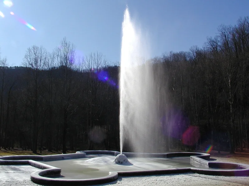

Andrews Geyser
The water shoots eighty feet straight up out of the trees, and the trick is that nothing pumps it. No motor hums in the woods near Old Fort. No mechanism gives the column its lift. The pressure comes from physics alone: a pond five hundred feet upslope, a two-mile cast iron pipe running downhill through the laurel, and a half-inch nozzle pointed at the sky. Colonel Alexander Boyd Andrews of the Southern Railway helped engineer the climb that brought trains from the Piedmont up to Asheville. He never lived to see the version that stands here today, but the fountain that bears his name keeps doing what it was built to do in 1885 — catch the eye of anyone passing through the gap.
The Bodies in the Tunnels
Before the geyser, there was the railroad, and before the railroad, there were the men who died building it. Roughly 120 workers lost their lives carving the line between Old Fort and Asheville in the late 1870s and 1880s, blasting through the Eastern Continental Divide at Swannanoa Tunnel and threading six tunnels across seven and a half miles of relentless grade. Many of them were convict laborers, mostly Black men leased from North Carolina prisons under a system that treated their lives as expendable. Andrews Geyser was conceived as ornament for the Round Knob Hotel, where wealthy passengers paused to admire the mountains. It was also explicitly a memorial. Old Fort has more recently raised a separate monument acknowledging the enslaved and incarcerated workers by name. The geyser is the older marker, and one that has always meant two things at once.
How Gravity Works When You Ask It Nicely
The original Round Knob Hotel burned to the ground in 1903, and the fountain it adorned fell into ruin. In 1911, the New York financier George Fisher Baker — a friend of Andrews and one of the era's quieter Gilded Age titans — paid for a restoration. The railroad refused to renew the easement on the old location, so workers moved the basin seventy yards across Mill Creek and rebuilt it with five sides. The water still comes from a small dam on the Long Branch of Mill Creek, now part of the Inn on Mill Creek property uphill. A six-inch cast iron pipe carries that water under the forest floor for nearly two miles. By the time it reaches the half-inch nozzle, the five-hundred-foot drop has converted gravity into a column of water tall enough to scrape the canopy. When summer droughts dry the supply pond, the fountain rests.
A Senior Class and a Novelist
The geyser nearly disappeared again in the mid-twentieth century. By the late 1960s it was choked with debris and forgotten by all but locals. The Old Fort High School Senior Class of 1971 cleaned the basin and the grounds, and the town rededicated the fountain on May 6, 1976. A few years earlier, in 1967, the North Carolina novelist John Ehle had published The Road, a historical novel about the railroad's construction. His fictional engineer ends the book gazing at the geyser, the spray standing in for everything the line had cost and everything it had achieved. The fountain endures partly because writers, students, and Old Fort residents kept finding reasons to care about it.
What the Name Doesn't Say
Despite the name, it is not a geyser. Geysers are geothermal, driven by superheated water flashing to steam underground. This is a fountain — a beautiful piece of nineteenth-century hydraulic engineering dressed up as a natural wonder. The misnomer stuck because the effect is uncanny: a perfectly vertical jet of cold mountain water erupting from a granite basin in the middle of nowhere, with no visible apparatus. Most fountains require energy. This one only requires geography, and the patience of a railroad colonel who understood both.
From the Air
Andrews Geyser sits at roughly 35.655 N, 82.241 W on the steep western face of the Blue Ridge escarpment near Old Fort, McDowell County, North Carolina. Best viewed from low altitude on calm clear days when the column can be seen rising above the canopy. Asheville Regional Airport (KAVL) is about 18 nm to the west; Hickory Regional (KHKY) is roughly 35 nm to the east. The Swannanoa Tunnel and the Old Fort horseshoe curves of the Norfolk Southern line lie immediately above the site — be aware of the steeply rising terrain west toward the 2,700-foot Eastern Continental Divide at Swannanoa Gap.
Nearby Stories
- Historic Campbell Building 4.8 km away
- Green River (North Carolina) 14 km away
- Brevard, North Carolina 14 km away
- Linville Gorge 17 km away
- Hickory Museum of Art 26 km away
- Pisgah National Forest 31 km away
- Earnest Farms Historic District 38 km away
- Moravian Falls, North Carolina 44 km away