
Antandrus
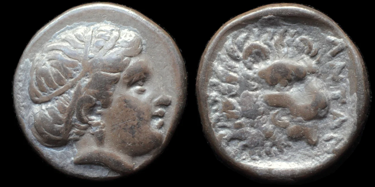
Even in antiquity, no one could agree on who founded Antandrus. The poet Alcaeus said Leleges. Herodotus said Pelasgians. Thucydides said Aeolian Greeks. Aristotle explained its nickname Kimmeris as evidence of a century under Cimmerian nomads from southern Russia. A mythographer in the age of Augustus offered two entirely different explanations, both involving wordplay on the Greek word for 'man.' The city was prosperous enough to attract all this scholarly attention — and old enough for its origins to have been genuinely forgotten. What is certain is that by the late 5th century BC, Antandrus sat on its hill above the Gulf of Adramyttium, controlled access to the timber forests of Mount Ida, minted silver coins bearing Artemis on one face and a lion on the other, and was considered strategically important enough that Persian satraps, Athenian admirals, and Spartan generals all wanted to hold it.
A Hill Above the Gulf
Antandrus stood on Devren hill, between the modern village of Avcılar and the town of Altınoluk, in what is now the Edremit district of Balıkesir Province. The geographer Strabo located it on the southern flank of Mount Ida, east of Assos and Gargara but west of Adramyttium. For modern scholars, its rediscovery came in stages. In 1842, the German geographer Heinrich Kiepert found an inscription mentioning Antandrus in the wall of a mosque at Avcılar. Returning in 1888, he found a second inscription and, guided by local reports of Greek, Roman, and Byzantine coins turning up in the vicinity of Devren hill, identified the site of the ancient acropolis. The British archaeologist John Cook confirmed the identification through surveys in 1959 and 1968.
Recent Turkish excavations have transformed the picture. Greek pottery from the necropolis dating to the late 8th and early 7th century BC has been uncovered — evidence of occupation almost two centuries earlier than previous surface finds had suggested. The material culture of this period appears overwhelmingly Greek, which complicates but does not resolve the ancient debate about the city's origins.
Timber, Fleets, and the Peloponnesian War
Antandrus appears repeatedly in the military history of the late 5th century BC because of a single resource: the abundant timber of Mount Ida. In an age when naval power depended entirely on wood, controlling the forests above Antandrus meant controlling the capacity to build warships. The city joined the Delian League in 427 BC and appears in the Athenian tribute lists from 425/424 BC with an assessment of eight talents — substantial, indicating real prosperity.
In 424 BC, the city was seized by exiles from Mytilene. Then, in 411/410 BC, its Persian garrison was expelled with help from Peloponnesian troops stationed at Abydos on the Hellespont. Freedom was brief. The Persians returned, and in 409 BC the Persian commander Pharnabazus used Antandrus to build a fleet for Peloponnesian forces — using exactly the timber that made the site so valuable. That same year, Syracusan troops helped rebuild the city's fortifications, suggesting a recent siege. In the summer of 399 BC, the famous Ten Thousand — the Greek mercenaries whose march home from Persia Xenophon recorded in the Anabasis — passed through Antandrus on their way north.
Where Aeneas Built His Ships
Virgil chose Antandrus as the place where Aeneas, the Trojan prince, builds his fleet before leading the survivors of Troy westward toward Italy. The passage in the Aeneid is brief, but the choice was deliberate: Antandrus was associated with Trojan territory, and its forests made it the logical place for such a construction project. One mythographic tradition even claimed that Ascanius, the son of Aeneas, had once ruled the city before it was captured by Pelasgians and ransomed — the name Antandros being explained as 'in place of a man,' meaning the man Ascanius.
This literary connection gave Antandrus a resonance in the Roman imagination that outlasted its actual importance. The city continued to mint coins from approximately 440 to 284 BC, resumed coinage under the Emperor Titus (AD 79–81), and continued until the reign of Elagabalus (AD 218–222). In the Byzantine period it was an episcopal see in the metropolis of Ephesus. As late as the 14th century, an Ottoman admiral used the site to build a large fleet of several hundred ships — the forests of Mount Ida still providing what they had always provided.
Pithos Burials and Ongoing Excavation
Modern excavations at Antandrus have accelerated in recent years, and the finds have been striking. In 2018, archaeologists unearthed pithos burials — the large storage-jar interments used across the ancient Aegean world. The necropolis, which occupies a slope 500 metres west of the acropolis, was in active use from the 8th century BC to the 1st century AD. That same year, a 2nd-century BC stele was discovered commending a military commander sent to Antandrus by Eumenes, King of Pergamon, and his brother Attalus.
In 2021, further pithos burials came to light. In 2022, tombs from the 3rd, 4th, and 5th centuries BC were identified. The excavation is ongoing — visitors can observe the work in progress on Devren hill and at the necropolis — and each season adds to a picture of a city that was, for much of its history, neither marginal nor provincial but genuinely enmeshed in the larger Mediterranean world.
The Question That Persists
Two and a half millennia after the poets and historians first argued about it, the question of Antandrus's origins remains unsettled — and in a certain light, that unsettledness is itself revealing. The city was old enough for its founding to be legendary rather than documented. It was prosperous enough for its identity to matter. And it sat at a crossroads of peoples — Leleges, Mysians, Cimmerians, Aeolian Greeks, Persians, Athenians, Romans — whose movements across this corner of Anatolia were themselves imperfectly understood even in antiquity.
Standing on Devren hill today, with the Gulf of Edremit blue below and Mount Ida's forested slopes rising behind, you can see why every successive civilisation found this place worth claiming. The view alone might explain the argument.
From the Air
Antandrus sits at approximately 39.58°N, 26.79°E, on Devren hill between the modern village of Avcılar and Altınoluk, on the north shore of the Gulf of Edremit. Approaching from the north at 4,000–6,000 ft, the gulf opens wide to the south, with Mount Ida (Kazdağı, 1,774 m) visible as the dominant peak to the northeast. The coastal strip below — olive groves, beach resorts, and the terraced hillside of Devren — is clearly distinct from the forested slopes above. Nearest airport: LTFD (Balıkesir Koca Seyit Airport, near Edremit), approximately 30 km southeast. Regional alternative: LTBG (Bandırma Airport), about 110 km north-northeast.
Nearby Stories
- Troy 13 km away
- 1953 Yenice–Gönen Earthquake 16 km away
- Mithymna 16 km away
- Ayvalık 18 km away
- Altıkulaç Sarcophagus 30 km away
- Balıkesir 40 km away
- Agia Paraskevi, Lesbos 44 km away
- Akhisar Museum 62 km away