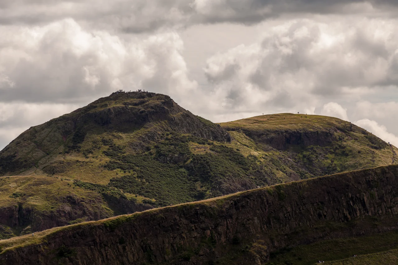

Arthur's Seat
In June 1836, five boys hunting rabbits on the crags of Arthur's Seat pushed aside a slate and found a small hidden cave. Inside lay seventeen miniature coffins, each about four inches long, each containing a tiny carved wooden figure dressed in handmade clothes. The boys were children, so they did what children do: they pelted the coffins at each other for fun. Eight survive, displayed today in the National Museum of Scotland on Chambers Street. Nobody knows who made them, or why. Theories run from witchcraft to a memorial for the seventeen victims of the Burke and Hare murders of 1828. The mystery has never been solved. It happens on a hill that has been confounding people for much longer than that - an extinct volcano in the middle of Edinburgh, 340 million years old, where James Hutton first saw deep time.
The Volcano in the City
Arthur's Seat rises 250.5 metres above the city centre, less than a mile east of Edinburgh Castle, forming the main peak of Holyrood Park. Robert Louis Stevenson called it 'a hill for magnitude, a mountain in virtue of its bold design.' From some angles - especially from the city centre - the hill resembles a lion couchant. Two of its several extinct vents form what Edinburghers call the Lion's Head and the Lion's Haunch. The volcano was active in the early Carboniferous period; lava samples have been dated to between 341 and 335 million years ago. The hill we see today is what remains after a glacier ground over it from west to east during the Quaternary, exposing the rocky crags facing the city and leaving a long tail of debris swept eastward. Salisbury Crags, the basalt cliffs between Arthur's Seat and the centre of Edinburgh, formed in the same way. Despite its volcanic origins, the hill is easy to climb - a green slope rises gently from Dunsapie Loch on the eastern side.
Hutton's Section
In the late eighteenth century, James Hutton walked these crags and watched the rocks. The conventional thinking of the day, drawn largely from biblical chronology, held that the Earth was perhaps six thousand years old, and that its rocks had been laid down in a single biblical flood. What Hutton saw on Arthur's Seat contradicted that completely. He observed, embedded in the Salisbury Crags, a place where molten magma had clearly forced its way up through pre-existing sedimentary rock, baking and disturbing it. The sedimentary layers below had taken vast time to form. The igneous intrusion above came later, also taking vast time. Different rocks, different ages, different processes. This place is now called Hutton's Section, and it is, in a real sense, where geology became geology. Hutton's principle of uniformitarianism - the idea that the same slow processes we see today, operating over immense stretches of time, produced the rocks beneath our feet - opened the door for Darwin and modern earth science.
Hill Forts and Bonfires
Long before the geologists, the hill was a fortress. An Iron Age hill fort occupied the summit and the subsidiary peak of Crow Hill. Hill-fort defences are visible round Dunsapie Hill and above Samson's Ribs. The forts were probably centres of power for the Votadini, the British tribe whose poets composed Y Gododdin around 600 AD - one of the oldest surviving works of Welsh-language poetry. The name Arthur's Seat may come from the same Brittonic Arthurian tradition; several other British hilltops carry the same name. The crags have witnessed many of Edinburgh's public moments. On 1 May 1590, the city celebrated the safe return of James VI and Anna of Denmark from Norway by lighting a bonfire on Salisbury Crags fuelled with ten loads of coal and six barrels of tar. The path running below the crags was paved in the aftermath of the Radical War of 1820 using the labour of unemployed weavers from the west of Scotland, employed on Walter Scott's suggestion as a form of work relief. It became known as the Radical Road, and remained a popular walk for two centuries. It has been closed since 2018 after fifty tons of rock fell from the cliffs above.
Pilgrimage and Dew
Tradition holds that David I, hunting in the forest of Drumselch at the foot of this hill in the twelfth century, fell from his horse before a stag. The animal was about to gore him when a cross appeared between its antlers. The stag turned away. David founded Holyrood Abbey on the spot - now ruined, beside the Palace of Holyroodhouse at the hill's western base. The burgh arms of the Canongate still display the stag's head with the cross framed by its antlers. Other pilgrims have come for other reasons. The slopes facing Holyrood are where Edinburgh girls traditionally washed their faces in the dew on May Day to make themselves more beautiful - Robert Fergusson wrote of the custom in his 1773 poem 'Caller Water.' In 1840, Mormon apostles dedicated Scotland for the preaching of their gospel from this summit. In 1884 the Italian alpine guide Emile Rey, who had climbed in the Mont Blanc massif, visited Edinburgh and estimated it would take most of a day to reach the top. He climbed it in considerably less.
Fly Past
Arthur's Seat sits at 55.944 degrees north, 3.162 degrees west, at the heart of Edinburgh's Holyrood Park, immediately east of the Royal Mile and the Palace of Holyroodhouse. The summit rises 251 metres above sea level, with the basalt cliffs of Salisbury Crags forming a long bow-shape on its western flank. From above, the lion couchant outline is most distinct from the south. Edinburgh Castle is visible one mile to the west on its own volcanic plug. Best viewed from 1,500 to 3,000 feet to see the relationship between the two volcanic remnants. Nearest ICAO airport: Edinburgh (EGPH) ~6 nm west. The Firth of Forth opens to the north; the volcanic plug of North Berwick Law is visible to the east on clear days. The hill is part of the Arthur's Seat Volcano SSSI. Edinburgh's haar fogs can completely shroud the summit while leaving the city below in sun.
From the Air
Located at 55.9442°N, 3.1619°W in Holyrood Park, central Edinburgh, immediately east of the Royal Mile. Summit elevation 251 metres. Recommended viewing altitude 1,500-3,000 feet. Visual landmarks: lion-couchant profile of the hill from the south; Salisbury Crags bow-shape on western flank; Edinburgh Castle one mile west on its own volcanic plug; Palace of Holyroodhouse at the hill's western base. Nearest ICAO airport: Edinburgh (EGPH) ~6 nm west. North Berwick Law visible to the east on clear days. Haar fog can shroud the summit while leaving the city below in sun.
Nearby Stories
- Blackness Castle 2.2 km away
- Skateraw Lifeboat Station 2.8 km away
- RAF Charterhall 5.6 km away
- Ochil Hills 6.3 km away
- Innerleithen 12 km away
- Falkland Palace 14 km away
- New Lanark 18 km away
- Bell Rock Lighthouse 21 km away