Baltrum
There are no street names on Baltrum. Find a postcard, look at the address, and you will see only a house number - 47, 112, 286 - and the island's name. The number is not a location. It is a date. Houses on Baltrum are numbered in the order they were built, so a low number means the building is old, and a high number means it went up recently. Roughly 300 of them in 2009, climbing slowly each year. Walk the lanes and you can read the chronology of the village in its mailboxes.
An Island That Moved
Baltrum is a barrier island that has been drifting east for centuries. Between 1650 and 1960, its west coast shifted about five kilometers in that direction; its east coast moved only a kilometer and a half. A 1650 inspection found just fourteen people clinging to it, in danger from the sea. In 1737 a village with a church stood where the surf now breaks; it was abandoned around 1800 when shifting dunes silted it under. A new western village was built closer to where the present harbor sits, and then a great storm surge in 1825 broke the whole island into pieces. Most of it became uninhabitable. The western village was deserted again. From 1870 onward, engineers tied Baltrum down with groynes, palisades, and revetments, and the dunes have stayed put long enough for a town to settle in earnest.
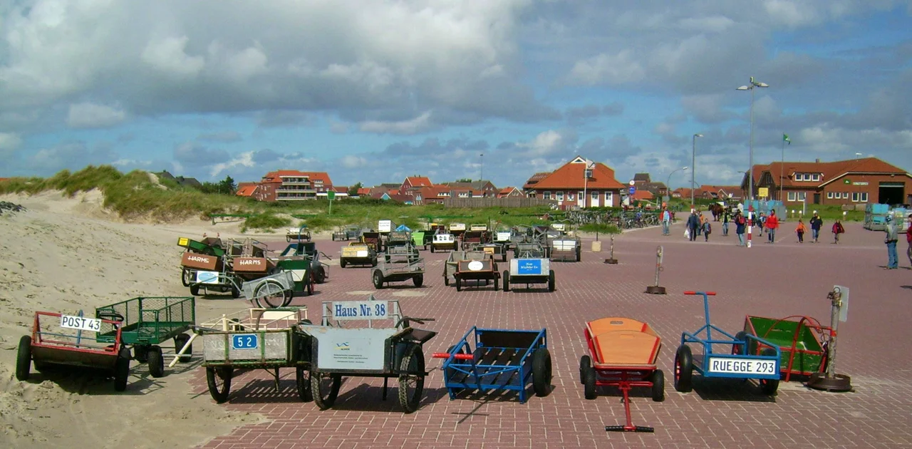
The Quietest Six Square Kilometers
Today Baltrum covers about 6.5 square kilometers - five kilometers long, a kilometer and a half wide - and roughly 600 people live there year-round. The two original villages, Ostdorf and Westdorf, have grown together into one, though locals still know where the seam runs. No cars are allowed. The only motor vehicles are the volunteer fire engine, an ambulance, a few wheel loaders, and the machines that keep the coastal defenses standing. Even bicycles belong to the residents; visitors are asked to leave theirs on the mainland. Luggage rolls off the ferry in containers and is hauled to guesthouses by horse-drawn carriages or hand-pulled carts. From 1949 to 1985, a narrow-gauge railway called the Inselbahn carried baggage across the dunes. Its tracks are gone, but the rhythm it set - slow, deliberate, fitted to a small place - persists.
The Name and the God
Where does the name Baltrum come from? Nobody is quite certain. The first written record is from 1398, when Widzel tom Brok handed the East Frisian islands to Duke Albert I of Bavaria and got them back as a fief. The document calls the island Balteringe, which in Old Frisian could mean either "pasture" or "the place of Balter's sons." There is a more romantic possibility: that the name traces back to Baldr, the Norse god, son of Odin and Frigg, the bright god whose death the Eddas mourn. The latest theory is the most playful. In modern German, bald 'rum could be read as "soon around" - because walking the island's fifteen-kilometer circumference doesn't take long. The locals tell that one with a smile. It is not the etymology a linguist would accept, but it has the merit of being true to the place.
Three Churches, One Palisade
For a six-kilometer island, Baltrum has a generous inventory of churches. The Old Church was built in 1826 as a Lutheran chapel, later served as a Catholic church, then a morgue, and now hosts weddings and concerts. The Great Lutheran Church went up in 1929-30; its tower was raised in 1964-65. Saint Nicholas Church, Catholic, was founded on Saint Nicholas Day in 1956 and has the unusual feature of being two buildings - a small winter church seating fifty and a thatched-roof summer church that holds three hundred. The architect was Heinrich Feldwisch-Drentrup of Osnabrück, and Margarete Franke designed the glass windows. Out on the southwestern shore, a historical palisade remains in place, first driven in during the 1880s and rebuilt in 1930-31. It is heritage-protected. Most of it is gone, but the stretch between the harbor and the western point still stands like a row of teeth set against the tide.
The Mudflat Walk
When the tide is far out, you can walk to Baltrum. The path begins at Neßmersiel on the mainland and takes about two and a half hours across the watt - the muddy seafloor exposed twice a day by the falling sea. Guides lead the walks, because conditions change and the channels are not forgiving. The reward is arriving by foot on a barrier island that drifts a little east every century, where your address will be the day your house was built.
From the Air
Located at 53.73°N, 7.37°E - center of the East Frisian Islands chain. Baltrum is unmistakable from the air: a small crescent-shaped barrier island about 5 km long, with dunes running along its north side and the watt mudflats to the south. Recommended viewing altitude 1,500-3,000 ft for the full sweep of the island chain - Norderney to the west, Langeoog to the east, separated by the tidal channels Wichter Ee and Accumer Ee. Norderney Airport (EDWY) is the nearest aerodrome with a paved runway; Baltrum's own grass airstrip serves Norddeich. At low tide the exposed mudflats double the apparent landmass. Best light is early morning when tidal channels glow silver.
Nearby Stories
- Organ in the Jacobikerk at Uithuizen 3.4 km away
- OLT Express Germany 5.6 km away
- Alpha Ventus Offshore Wind Farm 7 km away
- Harle (gat) 11 km away
- Battle of Heligoland (1864) 12 km away
- Borkum 13 km away
- Gode Wind Farm 15 km away
- Varel 27 km away