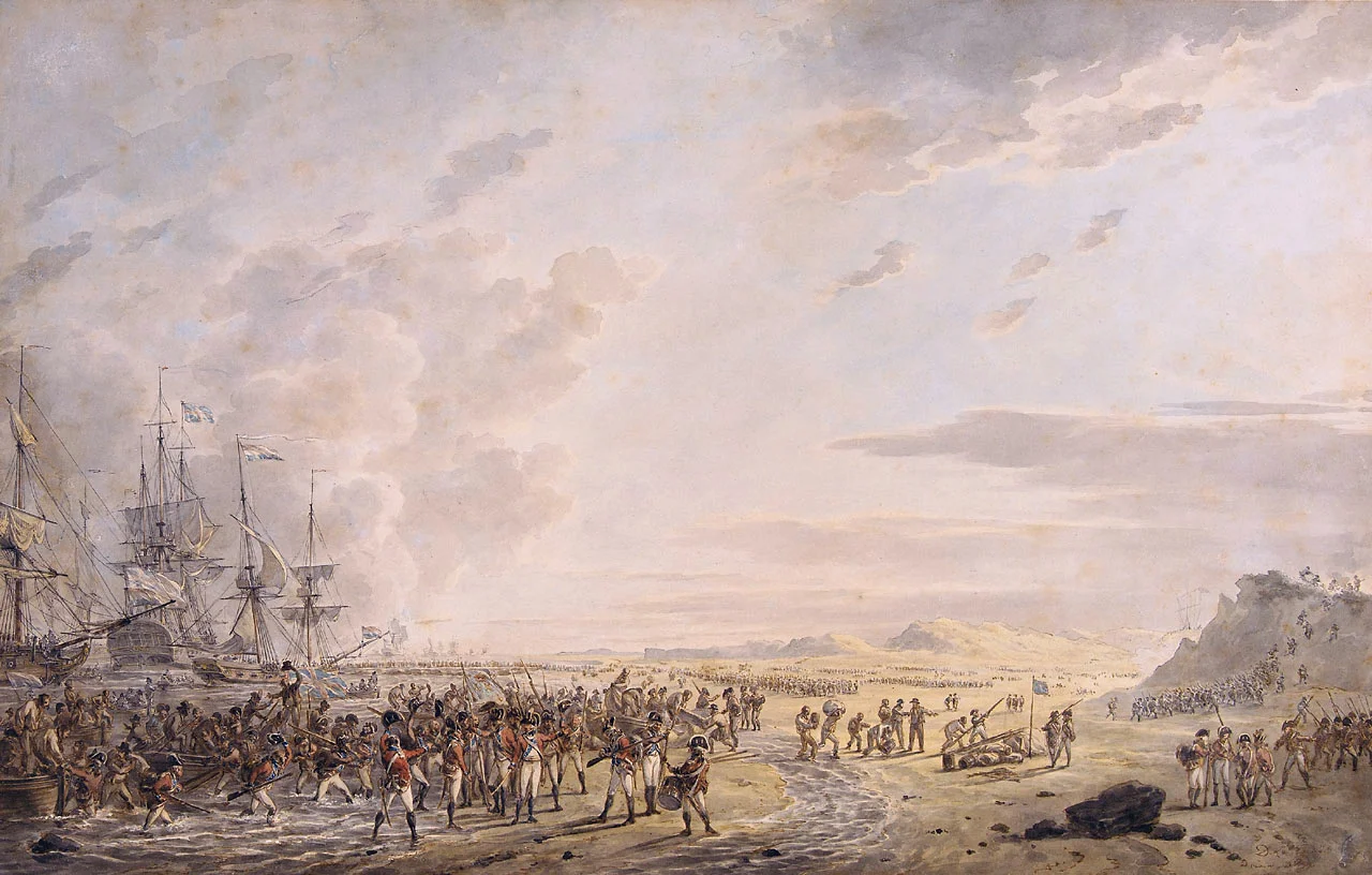
Battle of Callantsoog
Twenty British soldiers drowned before they ever set foot on the Dutch coast. Their boat capsized in the surf off Kleine Keeten on the morning of 27 August 1799, and the North Sea took them while the rest of the invasion fleet finished the work of putting twelve thousand men ashore. The first man to make landfall was a Lieutenant Macdonald of the Grenadier company of the 25th Foot. The first man to die in command was a Lieutenant-Colonel Luck of the Batavian Republic, killed within minutes of the British assault on the dunes above the beach. By six in the evening, two hundred and eleven men were dead between the two armies, more than a thousand wounded, and the Batavian general Herman Willem Daendels was retreating south toward Alkmaar. The Anglo-Russian invasion of Holland had begun.
Why North Holland
British planners had spent months arguing about where to land. The Scheldt estuary was one option; Scheveningen near The Hague was another, with promised support from Orangist partisans loyal to the exiled stadtholder William V. They chose the extreme northern tip of the North Holland peninsula instead, because the coast there had fewer shoals, because the defenses were thin - a few sconces and shore batteries at Den Helder, no more - and because of the prize sitting in the roadstead just inside: the northern squadron of the Batavian fleet, anchored and undermanned. Take Den Helder, capture the squadron, march on Amsterdam. The plan was tidy. The execution would not be.
The Spit
The terrain in 1799 was not the terrain a modern map shows. Den Helder was a hamlet, not a town. South of it ran a narrow spit of dunes, half a mile across at its widest, with the North Sea on one side and the Wadden Sea on the other and a shallow marsh called the Koegras behind. A road called the Zanddijk ran the length of it, bordered by a canal. The whole strip was so narrow that the Batavian commander, Daendels, decided he could not deploy his division across it. Instead he split his force - about five thousand men under Major-General Van Guericke at Den Helder, about five thousand more under his own command at Callantsoog - and planned to catch any landing in a double flank attack as soon as the British boots hit the sand. It was a bold disposition and, in the event, an unworkable one.
Twenty Drowned
At three in the morning of 27 August the British vanguard climbed into the boats. There were not enough boats for everyone, so the landing came ashore in waves. The naval guns of Admiral Mitchell's fleet swept the beach with cannonade, throwing up enormous gouts of sand that did almost nothing to the Batavian defenders crouched behind the first row of dunes. The British 3rd Brigade and Reserve - twenty-five hundred men - made landfall at Kleine Keeten, where a semaphore station stood on the dune ridge. They went for it. The Batavian skirmishers fell back as planned, but the inexperienced line battalion behind them panicked instead of opening their ranks. Lieutenant-Colonel Luck died trying to hold them. A counter-attack with the bayonet by the 2nd of the 5th Demi-brigade was also driven back, and its commander Lieutenant-Colonel Herbig was killed too. Only one British boat capsized in the landing. It capsized with twenty men aboard, and all of them drowned within sight of an army they never reached.
Sand and Gunfire
What broke the Batavian counter-attack was not just numbers. It was the ground. Daendels fed his reinforcements piecemeal into the dunes south of the British position - elements of the 1st, 3rd, 5th, and 6th Demi-brigades, supported by Captain d'Anguerand's horse artillery - but the loose dune sand swallowed everything that moved. Horses sank to their bellies. Gun carriages bogged down. Meanwhile the British gunboats nosed close inshore and fired through the gaps in the dunes whenever Batavian troops crossed open ground. The naval gunfire wrought havoc. Daendels could see his men being chewed apart and could find no way to bring his weight to bear. By six in the evening he ordered a withdrawal to the Zijpe polder. The British did not pursue. They had what they came for: a beachhead.
A Town Without a Fight
The consequence was disproportionate. With Daendels gone and Van Guericke cut off in the Koegras marsh, the troops north at Den Helder under Colonel Gilquin were left exposed. Daendels ordered them out too, by a roundabout route through the swamp. Before they left, they spiked all eighty-six guns in the shore batteries at Den Helder. The next morning the British walked into the town. The roadstead of Nieuwediep, with its anchored Batavian ships of the line and its naval arsenal, fell into British hands without a shot fired. Three days later, in an event that has shadowed Dutch naval memory ever since, the crews of Admiral Story's squadron mutinied at the Vlieter and surrendered the entire northern fleet to Admiral Mitchell without firing back. The British losses at Callantsoog were 74 killed - including the twenty drowned - 376 wounded, and 20 missing. Two of the dead were senior officers: Lieutenant-Colonel Hay of the Royal Engineers and Lieutenant-Colonel Smollett of the 1st Foot. The Batavian army left 137 dead and 950 wounded on the dunes. The campaign that opened so well at Callantsoog would end three months later in capitulation. The men who died on this beach lay there for nothing in particular, in the end.
From the Air
The battlefield lies at approximately 52.85 degrees north, 4.70 degrees east, on the North Holland dune coast near the village of Callantsoog. Recommended viewing altitude is 2,000 to 4,000 feet, low enough to read the dune lines, the modern coastal road, and the wide beach where the 1799 landing took place. The dunes extend north toward Den Helder (10 km) and south toward Petten and the Hondsbossche Zeewering seawall. The polder country inland - including the Zijpe, where Daendels withdrew - is laid out in its classic Dutch reclamation grid and is unmistakable from the air. Nearest airfields: De Kooy (EHKD) at Den Helder, Amsterdam Schiphol (EHAM) 60 km south. North Sea winds and onshore haze are common.
Nearby Stories
- Action of 24 October 1798 4.4 km away
- Marquette Castle 6.8 km away
- Battle of Camperdown 8.1 km away
- Stavoren 8.9 km away
- Exposure 11 km away
- Harlingen, Netherlands 14 km away
- Luchterduinen Offshore Wind Farm 16 km away
- Antiope 46 km away