Battle of Gondar
The last Italian airplane in East Africa flew its final mission on 22 November 1941. Sergente Giuseppe Mottet took off in his Fiat CR.42 biplane, strafed British artillery at Kulkaber, killed the British Commander Royal Artillery, and then landed at Gondar and destroyed his own aircraft before picking up a rifle and joining the ground troops. It was, by any measure, a gesture. The Regia Aeronautica was gone from Africa. What remained was 40,000 Italian troops under General Guglielmo Nasi, sealed into a highland town 7,000 feet above Lake Tana, waiting for the British to come up the road.
The Road up the Escarpment
Gondar was always defined by the road that reached it. At Wolchefit, seventy miles out, the road chicaned up a 4,000-foot escarpment cut in places into the vertical cliff face. From there it traced the rim of the highlands through Dabat and Amba Giorgis before descending to Gondar itself. Hold the escarpment, and you held the town. That calculus explained why, through the summer and autumn of 1941, small Italian garrisons at Wolchefit and the Kulkaber mountain pass held out for months while Ethiopian patriots, British Indian Army units, and the 12th African Division closed in around them. Wolchefit's Colonel Mario Gonella surrendered on 28 September with 1,629 Italians and 1,450 colonial soldiers after losing 950 men in combat and running out of food.
Patriots of the Arbegnoch
The Ethiopian forces closing on Gondar were not auxiliaries. The arbegnoch - literally patriots - had been fighting the Italian occupation since the day Mussolini's troops marched into Addis Ababa in 1936. They had spent five years in the bush, feuding with Italian garrisons, protecting villages, and waiting for an army large enough to help them finish what Emperor Haile Selassie had begun. In November 1941 they fought alongside the King's African Rifles and South African battalions. Many askari, unpaid by the Italians for months, simply deserted the Gondar garrison rather than die for a cause that no longer paid its debts.
The Passes Fall
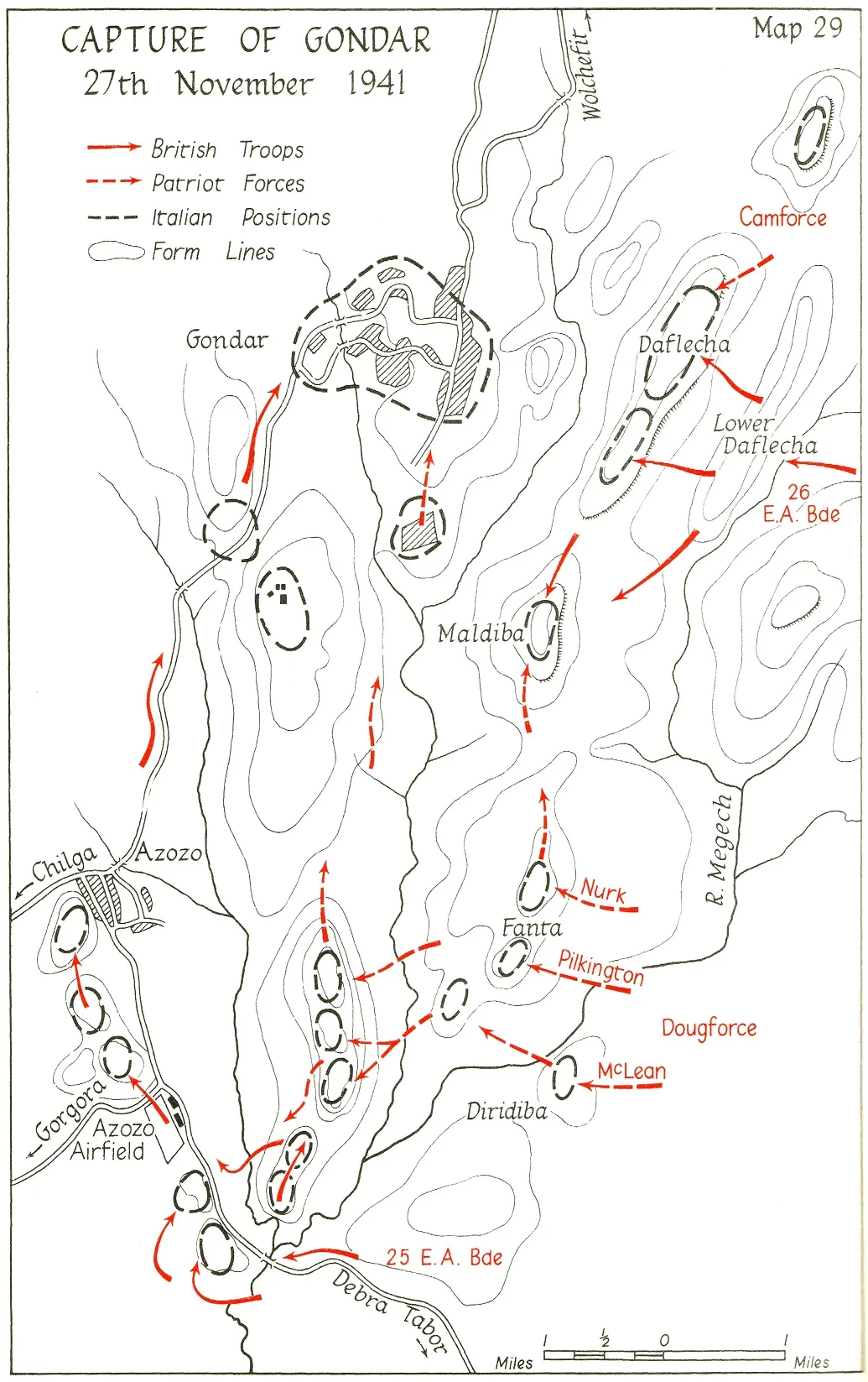
On 13 November Major-General Charles Fowkes sent the 12th African Division at Kulkaber with Ethiopian irregular support, and was repelled. The second attack on 21 November broke through. By the end of that day Italian sources recorded 1,003 killed, 804 wounded, and 1,900 taken prisoner. With the Culqualber and Wolchefit passes gone, the Allies owned the heights over Gondar itself. On 23 November Commonwealth troops reached the town's outskirts.
Fasilides' Castle, 27 November
The final assault began at 5:30 in the morning on 27 November. The Azozo airfield fell by midday. Hours later, Commonwealth troops stood at Fasilides' Castle - the 17th-century stone keep of Emperor Fasilides, the man who had made Gondar the permanent capital of Ethiopia in 1636 and whose dynasty shaped the town's skyline for two centuries. Now it was the backdrop for the collapse of Italian East Africa. At 4:30 p.m., as the Kenya Armoured Car Regiment entered Gondar, Nasi cabled Italy to report that his reserve brigade had failed, the barbed wire was breached, and enemy armour was in the streets. He surrendered soon after. Scattered outposts held out until 30 November.
What 'Last Stand' Meant
The phrase 'last stand' obscures what the battle actually ended. Mussolini's African Empire, proclaimed in 1936 to unite Ethiopia, Eritrea, and Italian Somaliland, was extinguished at Gondar after just over five years. For Haile Selassie, restored to his throne in Addis Ababa in May 1941, the fall of Gondar meant that the last Italian-held towns in his country were his again. For the Ethiopian patriots, it was the end of five years of guerrilla war. For the 40,000 Italian prisoners, it was the start of years of captivity. The castles of Fasilides, having watched empires rise and fall since the reign of the first Solomonic restoration kings, simply kept standing.
From the Air
Gondar lies at roughly 12.6N, 37.47E, 7,000 ft elevation on the high plateau north of Lake Tana. Recommended viewing altitude 10,000-12,000 ft AGL to appreciate the escarpments the battle was fought for. Gondar Airport (HAGN/GDQ) is at Azozo, just south of town. Bahir Dar (HABD/BJR) at Lake Tana is 140 km south. The Simien Mountains rise to the north above 13,000 ft - plan for significant terrain clearance and afternoon convective weather in the wet season.
Nearby Stories
- Lake Tana 40 km away
- Simien National Park 40 km away
- Debre Tabor 51 km away
- Welkait 103 km away
- Simien Mountains 115 km away
- Northern front, East Africa, 1940 160 km away
- Eritrea-Sudan Border 192 km away
- Gimbi Massacre 371 km away