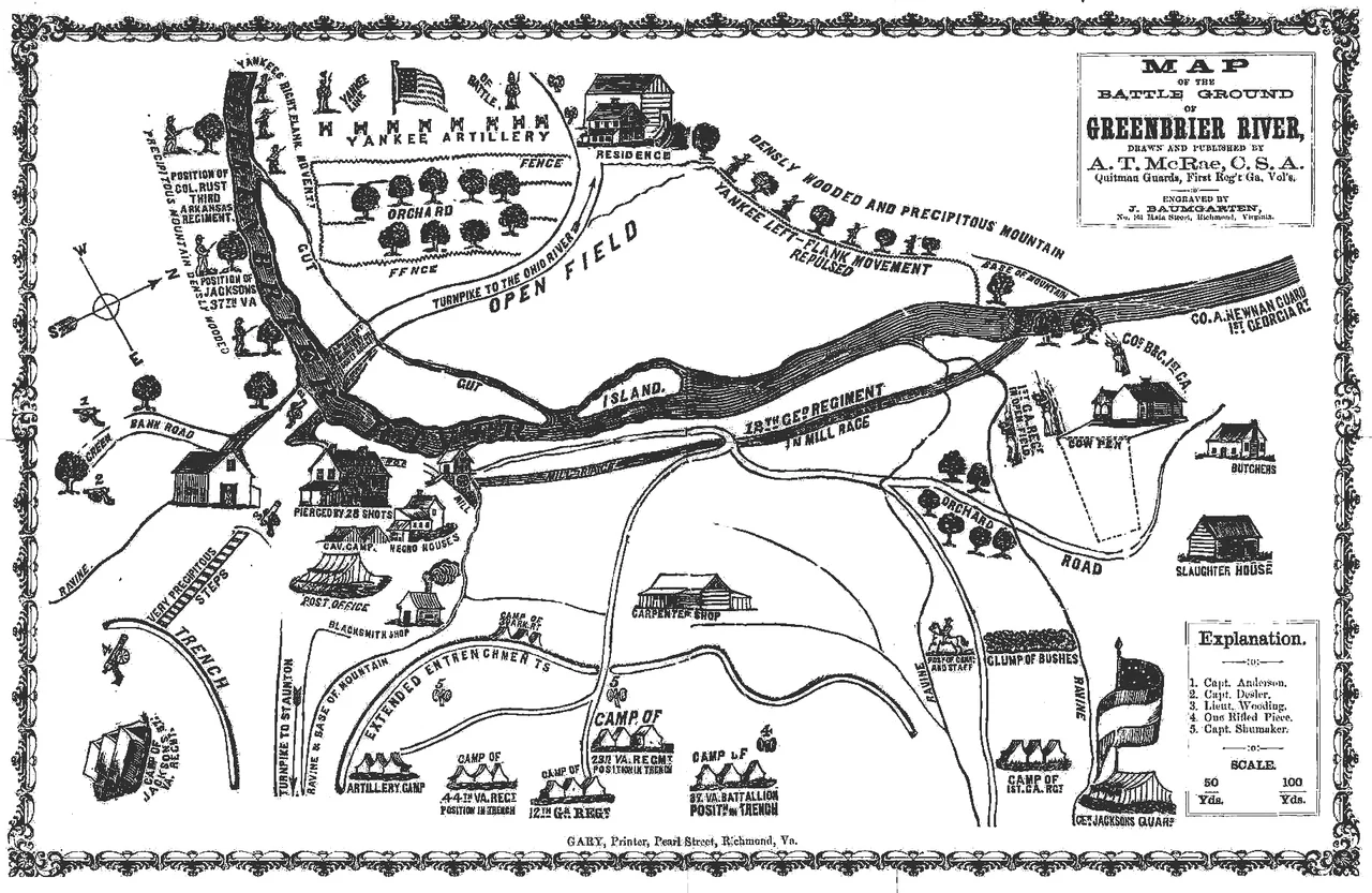

Battle of Greenbrier River
Both sides claimed they had inflicted 300 casualties on the other. Both sides had actually lost about 40 men. The Battle of Greenbrier River on October 3, 1861 - also known as the Battle of Camp Bartow - was the kind of small, inconclusive engagement that filled the western Virginia campaign of the early Civil War. Brigadier General Joseph Reynolds led 5,000 Union troops down from Cheat Mountain at midnight, reached the Confederate camp at daylight, fought for most of the day, and then withdrew at dusk. The Confederate force held its ground. Both sides went back to camp and wrote dispatches that bore only a passing relationship to what had happened on the ground.
A Camp at the Mountain Base
Camp Bartow had been established in mid-September 1861 by Confederate troops at the base of Cheat Mountain on the Greenbrier River in Pocahontas County. The camp was named for Francis S. Bartow, a Georgia colonel who had been killed at First Bull Run in July. The Confederate force was substantial on paper - the 1st and 12th Georgia Infantry under Colonel Edward Johnson, the 23rd and 44th and a battalion of the 25th Virginia Infantry under Lieutenant Colonel George Hansbrough, the 3rd Arkansas Infantry under Colonel Albert Rust, the 31st Virginia Infantry, two artillery batteries, and Churchville Cavalry from Augusta County. But Colonel William Taliaferro had reported that sickness had reduced his army to one-third strength. Camp life on a low-elevation West Virginia river in fall, with limited sanitation and inadequate medical care, was killing more Confederates than any Union army ever managed.
Reynolds Comes Down the Mountain
Brigadier General Joseph Reynolds commanded the Union forces at Cheat Mountain and Tygart's Valley. His men had recently repulsed Robert E. Lee's first Civil War offensive in September - the failed Cheat Mountain operation - and had also driven back General William W. Loring's troops. Confidence was high. Reynolds believed he could clear the Greenbrier valley and open a route into Virginia proper. On the night of October 2, he marched his force - about 5,000 men of the 24th, 25th, and 32nd Ohio Infantry, six Indiana infantry regiments, Battery G of the 4th U.S. Artillery, Loomis's Michigan battery, Battery A of the 1st West Virginia Light Artillery, and three cavalry detachments - down off Cheat Mountain in heavy rain. They reached Greenbrier by daylight, roughly four miles from Camp Bartow.
The Battle of the Day
At 8 a.m., Confederate pickets at the perimeter of Camp Bartow abandoned their posts as the Union force came into view. Union soldiers entered the camp itself. The Confederate troops inside the camp had trouble loading and firing their weapons - the rifles were inconsistent, ammunition was wet from the rain, and confusion was rampant. They were forced to move out into the open under Union artillery and rifle fire to organize a defensive line. When Colonel John Brown Baldwin of the 52nd Virginia Infantry heard the gunshots from his position about nine miles away, he immediately marched his regiment toward the sound of the guns. The Confederates initially thought the reinforcements would arrive too late. Instead, when Reynolds saw fresh Confederate troops appearing on the field, he chose to continue the engagement. The battle went on for approximately five more hours. By late afternoon, Reynolds ordered his troops to break off and return to Cheat Mountain.
The Math of the Casualty Counts
After the battle, both commanders wrote dispatches estimating enemy casualties at around 300 men. The actual numbers tell a different story. Union losses were 8 killed and 35 wounded. Confederate losses were 6 killed, 33 wounded, and 13 missing. The total casualties on both sides combined came to fewer than 100 men. The inflation of enemy losses was standard practice in 19th-century military reporting - a way for both commanders to claim a tactical victory and justify the day's effort to their superiors. Reynolds reported a successful reconnaissance and orderly withdrawal. The Confederate command reported repulsing a much larger Union force. Modern military historians categorize the battle as inconclusive, which is honest. Neither side gained meaningful ground. Neither side suffered crippling casualties. The strategic situation in western Virginia was effectively unchanged at the end of the day.
Preserved at Last
The Camp Bartow Historic District includes the battlefield, the Confederate encampment site, and surrounding ground. For over 150 years the land was held in various private hands and faced periodic threats from development. In 2016, in partnership with the American Battlefield Trust, the West Virginia Land Trust acquired 14 acres that preserve the core of the battlefield. The Staunton-Parkersburg Turnpike Alliance received a $46,000 grant from the National Park Service to develop a community preservation plan for the broader site. The 14 acres are now a small but meaningful patch of preserved ground along the upper Greenbrier - one of the smaller National Park Service-recognized Civil War battlefields in the country, but one that records a typical day of the early war. Eight men died on the Union side, six on the Confederate. Their names mostly survive in regimental records. The land where they died is now public.
From the Air
Located at 38.53 degrees north, 79.77 degrees west, in the Greenbrier River valley of Pocahontas County, West Virginia near the small community of Bartow. The battlefield sits along US Route 250 (the modern route of the Staunton-Parkersburg Turnpike) at the foot of Cheat Mountain. Best identified from VFR altitudes of 5,500 to 7,500 feet AGL where the river valley winds between forested ridges. The closest airports are Marlinton Municipal (W99) about 14 nautical miles south and Elkins-Randolph County (KEKN) to the north. The area is within the U.S. National Radio Quiet Zone affecting Green Bank Observatory - check NOTAMs. Watch for mountain wave and valley fog.
Nearby Stories
- Upshur County, West Virginia 8.6 km away
- George Washington and Jefferson National Forests 13 km away
- West Virginia Maneuver Area 13 km away
- Yew Mountains 13 km away
- Helvetia, West Virginia 14 km away
- Lighthorse Harry Lee Cabin 16 km away
- Gypsy Hill Park 18 km away
- Bath County Pumped Storage Station 19 km away