Brest Castle (Belarus)
When the German chronicler Thietmar of Merseburg wrote in 1017 that Yaroslav the Wise of Kievan Rus had captured a place called Berestye, he used the Latin word 'urbs.' The word could mean a fortified town or simply a fortress; the chronicler did not bother to distinguish. That ambiguity has haunted historians of Brest Castle ever since. They know there was a Slavic settlement at the confluence of the Mukhavets and Bug rivers by the early eleventh century. They know it was attacked, besieged, burned, and rebuilt many times. They know almost nothing about what it looked like, because in the nineteenth century the Russian Empire demolished what was left of the castle to build the Brest Fortress on top of it.
The First Berestye
The site was unusually defensible. The Bug River flows north here, the Mukhavets flows in from the east, and between them the rivers carve a tangle of islands and channels. The earliest fortified Slavic settlement, called Berestye, took advantage of all of it. Yaroslav the Wise's capture of Berestye in 1017 was important enough to reach German chronicles. In 1182, the Polish chronicler Wincenty Kadłubek described how Casimir II the Just attacked Brest first when he raided the Rus lands, calling it a place 'most protected by people, by the art of fortification, and by location,' surrounded by river branches. A document of 1099 in Old East Slavic calls Berestye a 'grad,' a fortified place. By the late medieval period, Brest was a regular stop on the trade routes between Poland, Lithuania, and the Rus principalities, and the castle was the seat that controlled it.
Drawn from Memory
The textual evidence runs out for centuries. We have hints of fires, sieges, and reconstructions, but no clear physical description until 1554, when Brest was granted an urban coat of arms showing a castle at the confluence of two rivers. The first detailed images came a century later, made under unhappy circumstances. In 1657, the Swedish military engineer Erik Dahlberg sketched plans and a panoramic view of Brest. He worked on the orders of King Charles X Gustav of Sweden, who had recognized the strategic importance of Brest in his war against the Polish-Lithuanian Commonwealth and wanted Dahlberg to design an 'impregnable fortified town' there. The plans were never built as Dahlberg intended. They were published in 1696 in a book by the philosopher Samuel von Pufendorf, leaving us the best surviving picture of what Brest Castle looked like before it was gone.
Erased by an Empire
The end came in 1833, after the Russian Empire absorbed the area in the partitions of Poland. Tsar Nicholas I's military engineers, led by Karl Opperman, planned a new star-shaped fortress on the same strategic site. The old town and castle of Brest were in the way. The decision was simple in imperial logic: the new fortress mattered, the old castle did not. The castle was demolished and the medieval town was cleared. The residents were resettled a few kilometers away to a new town that became today's Brest. By the time the Brest Fortress was completed in the early 1840s, the castle that had stood here for at least eight hundred years existed only in chronicles, in Dahlberg's drawings, and underground.
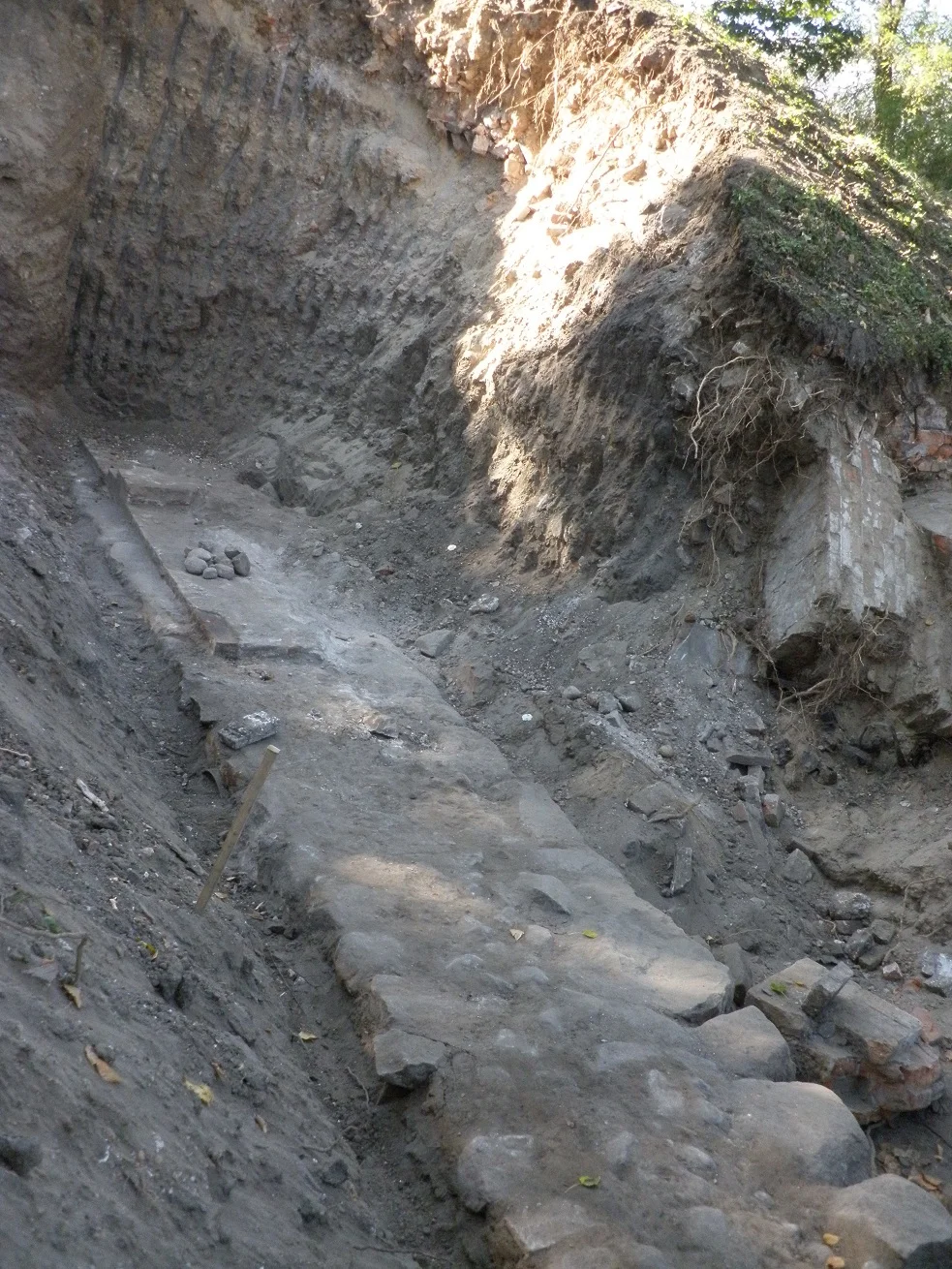
Looking for What Was Erased
The first archaeological excavation came in 1938 when the Polish officer Tomasz Marian Żuk-Rybicki dug at the site. He found elements of the old fortifications. Then World War II broke out, the war that would make the fortress on top of his dig site world-famous, and his results were lost until the 1990s. Between 1968 and 1981, a Belarusian team led by P. F. Lysenko returned to the site and uncovered something more: the remains of wooden structures, household utensils, weapons, jewelry, the ordinary stuff of medieval lives. Those finds now fill the Berestye Archeological Museum nearby, but the structures of the castle itself stayed elusive. Excavation resumed in 2013 with promising new findings. The medieval Brest Castle is a place that has to be reconstructed from fragments and memory. The river confluence that made it valuable is still here. So is everything that came after, sitting on top of what was there before.
From the Air
The site of the former Brest Castle lies at 52.08 N, 23.66 E in Brest, southwestern Belarus, on islands at the confluence of the Bug and Mukhavets rivers. The Brest Fortress now occupies the area. Best viewed at 3,000 to 5,000 feet to take in the star-shaped fortress overlying the medieval site, the river confluence, and the Polish border just to the west. Brest Airport (UMBB) is about 12 km northeast. Warsaw Chopin (EPWA) is roughly 200 km west. Note: Belarusian airspace currently has restrictions; verify before flying.
Nearby Stories
- Damachava Ghetto 15 km away
- Byaroza Monastery 50 km away
- Lubartów Ghetto 60 km away
- Treblinka Uprising 83 km away
- Branicki Palace, Białystok 91 km away
- Treblinka Extermination Camp 97 km away
- Dormition Cathedral, Volodymyr 113 km away
- Zhyrovichy Monastery 124 km away