.jpg)
Bromo Tengger Semeru National Park
Forty-five thousand years ago, a volcano the size of a small mountain range tore itself apart in an eruption comparable to Krakatau. What it left behind was a caldera -- a vast bowl of ash and rubble that would, over millennia, fill with a desert of volcanic sand at 2,100 meters above sea level. Then, from the floor of that ancient wound, five new volcanoes pushed upward. One of them, Mount Bromo, is still actively smoking. This is Bromo Tengger Semeru National Park, a place where geology operates on a scale that makes human timelines feel trivial, and where the people who live among these volcanoes have built a culture as distinctive as the landscape itself.
Volcanoes Within Volcanoes
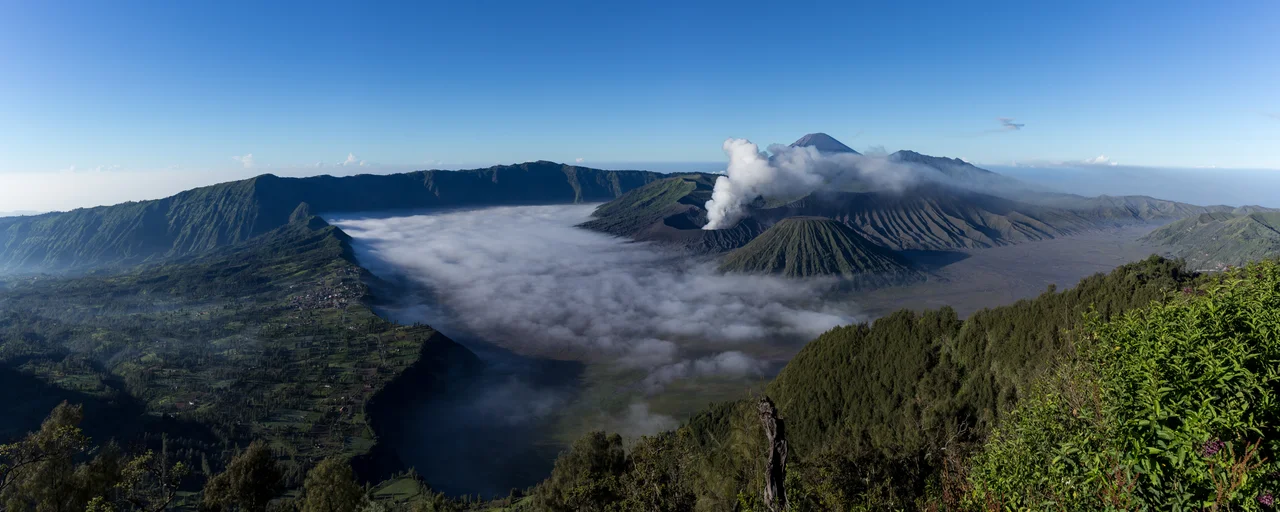
The Tengger Caldera is a geological nesting doll. The original eruption created a crater roughly ten kilometers across, ringed by walls that rise 200 meters above the sand sea at its center. From that sand sea, five volcanic cones have emerged: Mount Bromo at 2,329 meters, Mount Batok at 2,470 meters, Mount Kursi at 2,581 meters, Mount Watangan at 2,661 meters, and Mount Widodaren at 2,650 meters. Batok is the only one that has gone quiet, its slopes now covered in casuarina trees. Widodaren holds a cave considered sacred by local communities. Bromo remains the most dramatic -- a truncated cone trailing sulfurous smoke, its crater accessible by a staircase that climbs the ash-covered flanks. The caldera rim offers the most famous vantage point, particularly from Mount Pananjakan at 2,770 meters, where thousands gather before dawn to watch sunrise ignite the volcanic complex in shades of gold and violet.
Java's Highest Peak
South of the Tengger complex, the park harbors a second volcanic system: the Semeru Group. Mount Semeru stands at 3,676 meters, the highest point on Java, and one of the most consistently active volcanoes in the Indonesian archipelago. It erupts with such regularity that local guides can sometimes predict the intervals between ash plumes. The mountain's lower slopes are cut by rivers that follow former lava channels, and the surrounding forest transitions through distinct ecological zones -- tropical rainforest below 1,500 meters gives way to montane forest, then to barren volcanic scree above 3,100 meters where nothing grows. The park's lower elevations support 225 species of orchid alongside dense stands of fig, mulberry, and ginger family plants. Four lakes dot the terrain, including the isolated Ranu Tompe, and fifty rivers drain the massif's slopes into the fertile rice paddies that ring the park's boundaries.
The People of the Crater
The Tengger people number roughly 600,000 and live in thirty villages scattered through the mountains, including settlements within the park itself. They are one of the few significant Hindu communities remaining on Java, an island that is otherwise overwhelmingly Muslim. Their religious practice traces back to the Majapahit empire, the last great Hindu-Buddhist kingdom of Java, which collapsed in the early sixteenth century. As Islam spread across the lowlands, the Tengger retreated into the highlands -- or, more accurately, they stayed put while the world around them changed. Their faith resembles Balinese Hinduism but retains stronger animist elements, reflecting an older layer of Javanese spiritual life. Each year during the Yadnya Kasada ceremony, Tengger villagers climb Mount Bromo and throw offerings of food, livestock, and flowers into the active crater, honoring the volcano that both threatens and sustains them. The ceremony draws tourists, but for the Tengger it is a living obligation, not a performance.
The Sand Sea at Dawn
The Tengger Sand Sea covers 5,250 hectares, a flat expanse of grey-black volcanic sand stretching between the caldera walls and the volcanic cones at its center. It is the only sand sea within a conservation area in Indonesia. Crossing it on foot or horseback, as most visitors do to reach Bromo's base, produces a disorienting effect -- the ground is soft and featureless, the scale is difficult to judge, and the volcanic cones seem to hang above the sand rather than sit upon it. The climate reinforces the otherworldliness. From May through September, nighttime temperatures drop below freezing, and frost coats the sand in the predawn hours. By midmorning, equatorial sunlight has burned the frost away and the temperature swings upward. This daily cycle of freezing and thawing, repeated across thousands of years, has helped shape the sand sea's peculiar flatness. The park was first protected in 1919 and formally declared a national park in 1982, but the Tengger had been maintaining their own relationship with this landscape for centuries before any government drew a boundary around it.
From the Air
Located at 8.03S, 112.96E in East Java. The Tengger Caldera is unmistakable from the air -- a vast circular depression roughly 10 km across, ringed by steep walls, with five volcanic cones rising from a flat grey sand sea at the center. Mount Bromo's active smoke plume provides an additional visual marker. Mount Semeru (3,676 m), Java's highest peak, rises to the south and is often capped with its own volcanic plume. Approach from the north or west for the classic panoramic view. Abdul Rachman Saleh Airport (WARA) in Malang is approximately 50 km to the west. Juanda International Airport (WARR) in Surabaya lies roughly 100 km to the northwest. Recommended viewing altitude: 10,000-15,000 feet for the full caldera panorama.
Nearby Stories
- Kelud: The Mountain That Swallows Its Own Lake 23 km away
- Where an Empire's Memory Lives in Clay and Stone 23 km away
- Bangil Railway Station 31 km away
- Meru Betiri: The Last Forest on Java's Southern Edge 35 km away
- Shaken Foundations: The 2021 East Java Earthquake 65 km away
- Blue Fire and Bitter Water: Ijen Volcano 76 km away
- Where Three Worlds Meet: The Great Mosque of Sumenep 88 km away
- The Ghost Boat That Built an Empire 400 km away