.jpg)
Burketown Post Office
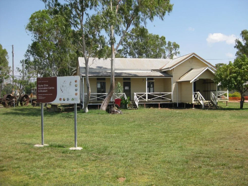
On 5 March 1887, a cyclone drove the waters of the Gulf of Carpentaria across Burketown and flattened most of it. The building that rose afterward on the colonial architect's plans was not a grand civic monument. It was a low timber post office with wide verandahs and high ceilings, designed to shed heat and survive the next blow. For more than a century that modest weatherboard building was the thread connecting one of the most isolated towns in Australia to the rest of the world. Today it stands on a corner facing the war memorial, repurposed as the tourist information centre, still doing the only job that ever really mattered out here: helping people find their way.
A Town That Kept Nearly Dying
Burketown's first decades read like a settlement that refused to take the hint. Pastoralists pushed into the Burke District in the 1860s after Burke and Wills and the explorer William Landsborough reported good grazing country. A government depot, a courthouse, a meatworks and the boiling down works gave the place ambition. Then a mystery disease — "Gulf Fever," never properly identified — killed so many people across 1866, 1867 and 1868 that the town was all but abandoned. The post office that had opened was shut by 1871. Only in the early 1880s did government services return for good, with the post office reopening on 1 January 1883. Its postmaster wore every hat the frontier required: police magistrate, customs officer, and weather forecaster all in one.
The Wire That Almost Went International
What changed Burketown's fortunes was the telegraph. The colonial government had once dreamed bigger still: it hoped Burketown would be the Australian landfall for an international cable running down from Java. Inter-colonial rivalry killed that ambition in 1872, when the contract for the overseas line went to South Australia instead. Queensland's consolation was a domestic line, and the wire finally reached Burketown in October 1886. For a remote community, the telegraph was transformative — news, orders and warnings that once took weeks by ship now arrived in minutes. The new 1887 post office was built as a combined Post and Telegraph Office, and from it radiated the overland mail routes: east to Normanton, south to Hughenden and Townsville, west via Gregory Downs to Camooweal, stitching together the scattered cattle stations of the north.
Designed for the Heat
The building itself is a small lesson in how colonial Queensland learned to build for the tropics. It is single-storeyed timber, clad in weatherboards, with an L-shaped plan that puts the public office at one end and a residence behind. The gabled corrugated-iron roof throws a projecting bay forward over the office entrance. Three open verandahs, high boarded ceilings, timber-framed window hoods and wide eaves all do the same patient work: catch the breeze, throw shade, make the savanna heat survivable. Inside, the office still keeps its timber counter and benches, old post office signs, and even a telephone exchange. It is a textbook example of a Queensland post office type popular from 1886 to 1896, with its distinctive triple-frontage and projecting office bay.
From Mail Counter to Map Counter
The post office slowly wound down with the century. Control passed to the new federal government after Federation in 1901; the building was downgraded in 1921, again in 1949, reclassified as a non-official office in 1964, reduced to an agency in 1985, and closed altogether in 1988. That same year, for the Bicentennial, the whole structure was lifted from its original site in Gregory Street and moved to its present, more prominent corner, where it briefly housed the office of the Gulf Air Company. As travellers began discovering the Gulf — drawn by the fishing, by the road improvements, by the World Heritage fossil fields at nearby Riversleigh — the old building found a second life as the town's tourist information centre. One of the few early structures left in Burketown, it still greets newcomers, just as it always did.
From the Air
Located at roughly 17.74°S, 139.55°E on the corner of Musgrave and Burke Streets in Burketown, on the northern fringe of the Gulf Savanna about 30 km from the Gulf of Carpentaria. Burketown Airport (YBKT) is at the town itself with 24-hour AVGAS and JET A1; Normanton (YNTN) lies to the east, Mornington Island/Gununa (YMTI) offshore to the north, and Mount Isa (YBMA) well to the south. From the air, pick out Burketown's small grid of unusually wide streets on the flat plain beside the Albert River; the building sits on a corner facing a concrete war memorial and three flagpoles. Best in the dry season (June-October) when the plains are firm and visibility is excellent; the wet (December-March) brings cyclones and flooding that can cut the town off for months. Recommended viewing 1,500-3,000 ft.
Nearby Stories
- 2000 Australia Beechcraft King Air Crash 26 km away
- Bentinck Island 40 km away
- Leichhardt Falls 60 km away
- Old Westmoreland Homestead 66 km away
- Flinders River 72 km away
- Lawn Hill crater 86 km away
- Wollogorang Station 110 km away
- Delta Downs Station 155 km away