
Burketown
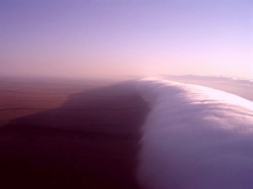
Roughly two hundred people live in Burketown, nine hundred kilometres of road west of Cairns, on the edge of a Gulf that floods them in and dries them out by turns. It is the kind of place a map almost forgets. And yet every spring the sky over this speck of a town does something it does almost nowhere else on the planet: it rolls. A tube of cloud, smooth as a wave and sometimes a thousand kilometres long, comes sweeping in low over the savanna at dawn, and glider pilots travel from around the world to chase it. Burketown is small. What happens above it is not.
Gangalidda Country, First and Still
Long before any of this carried European names, this was — and remains — the country of the Gangalidda (also written Yukulta) and Garawa peoples, who have lived in the southern Gulf for thousands of generations. The land around Burketown is so deep in human history that linguists and archaeologists place it near the homeland from which the Pama-Nyungan languages spread across most of the Australian continent. The traditional owners' connection was formally recognised in Australian law when native title was determined on 1 April 2015. That recognition came late, and it came after a hard century: between 1900 and 1974, government records show, more than 160 people were forcibly removed from Burketown, many of them children taken to distant missions. The Gangalidda and Garawa connection to this country was never a thing of the past. It is present tense.
A Frontier Built on Hope and Harm
Burketown takes its name from Robert O'Hara Burke, the explorer who died returning from the first crossing of the continent in 1860-61. The town was founded in 1865 by the Sydney financier Robert Towns as a port for his Gulf cattle stations; in the same year he also founded Townsville. Early Burketown was a rough place of humpies and high prices, so short of coin that merchants printed their own IOU currency on tissue paper, called "shinplasters." But the settlement came at a violent cost to the people whose land it took. As the Gangalidda were pushed off their hunting grounds, some speared the settlers' horses; the colonial response, carried out by the Native Police under Sub-Inspector Uhr, was slaughter. In 1868 a massacre of thirty Aboriginal people followed the killing of twelve horses, with twenty-nine more murdered soon after. A local newspaper of the day reported the killings with open approval. The honest history of Burketown holds both things at once: the pluck of a remote frontier town, and the bloodshed on which it was raised.
Fever, Cyclones, and the Stubbornness to Stay
Few towns have been so determined to survive themselves. From 1866 a sickness the settlers called "Gulf Fever" — possibly malaria or typhoid, never identified — tore through the population; estimates of the dead run from twenty-five to a hundred, and many lie in a mass grave in the town cemetery. Survivors were evacuated to Sweers Island for eighteen months. Then, on 5 March 1887, a cyclone pushed the sea across nearly all of Burketown, drowning the lower town and killing seven of its 138 people; only the high ground near today's council office stayed dry. The Gulf still runs the town's calendar. Its tropical savanna climate delivers about 810 millimetres of rain a year, almost all of it between November and April, when monthly falls can top 500 millimetres and floods cut Burketown off for months. Then the taps shut. In the failed wet of 1901-02, barely 170 millimetres fell and drought killed cattle by the million.
The Many Roads In
Burketown's story has always been one of people arriving from improbable directions. In the gold-rush decades of the late nineteenth century, large numbers of Chinese men came to the Gulf Country, many walking an astonishing 1,780-kilometre coastal track from Darwin to evade a punishing £10 poll tax aimed squarely at keeping them out. Some were arrested on arrival and held in the Burketown gaol; others slipped through and settled on the fringes of town, at Woods Lake and Hookeys Lagoon, where they grew market gardens whose fresh vegetables held off the scurvy that haunted remote settlements. Many built close lives with Aboriginal families, and people in the district today carry that shared Chinese and Aboriginal heritage. The town that grew from all this even slipped into fiction: Burketown is widely taken to be the model for "Willstown" in Nevil Shute's novel A Town Like Alice.
The Barramundi Capital and the Rolling Sky
Two things draw people to Burketown now, and both come up out of the water and the air. The first is the barramundi — Burketown calls itself the Barramundi Capital of Australia and runs a fishing competition each Easter, when the Gulf's rivers and coast fill with anglers chasing the silver fish. The second is the Morning Glory: a rare roll cloud, a smooth tube one to two kilometres high and up to a thousand kilometres long, often skimming only a hundred or two hundred metres above the ground. From late September into November it sweeps across the southern Gulf — the only place on Earth where it appears regularly and can be predicted — formed where sea breezes collide over Cape York and surge back as a single atmospheric wave. Glider pilots come from all over the world to ride its leading edge, soaring hundreds of kilometres on the lift of a cloud. Above a town of two hundred souls, the sky puts on a show the world has nowhere else to see.
From the Air
Located at roughly 17.72°S, 139.57°E on the Albert River, on the northern fringe of the Gulf Savanna a short way inland from the Gulf of Carpentaria. Burketown Airport (YBKT) is at the town with 24-hour AVGAS and JET A1 and Rex scheduled services via Mornington Island, Doomadgee and Normanton to Mount Isa and Cairns; nearby fields include Normanton (YNTN) to the east, Mornington Island/Gununa (YMTI) offshore to the north, and Mount Isa (YBMA) to the south. From the air, look for the small grid of unusually wide streets on the flat plain beside the tidal Albert River, the Gulf shore to the north, and Escott Station about 17 km west. The headline sight is the Morning Glory roll cloud at dawn from late September to early November — a smooth tube, sometimes a fleet of parallel tubes, sweeping in low across the savanna. Fly it with respect: it is genuine wave lift and serious soaring country. Best general visibility in the dry season (June-October); the wet (December-March) brings cyclones and flooding that isolate the town. Recommended viewing 1,500-4,000 ft, higher to take in the full sweep of a Morning Glory.
Nearby Stories
- 2000 Australia Beechcraft King Air Crash 26 km away
- Bentinck Island 40 km away
- Leichhardt Falls 60 km away
- Old Westmoreland Homestead 66 km away
- Flinders River 72 km away
- Lawn Hill crater 86 km away
- Wollogorang Station 110 km away
- Delta Downs Station 155 km away