Chad–Sudan border
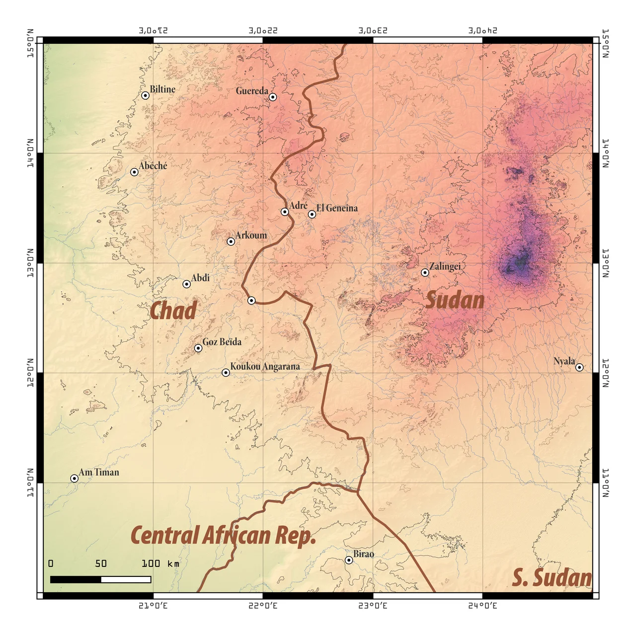
For 423 kilometers, the Chad-Sudan border is a straight line - it runs down the 24th meridian east from a tripoint with Libya in the northern Sahara. Then it gets interesting. At Wadi Hawar, the line breaks from geometry and begins to wander: an irregular thread defined by small streams, hills, hafirs, seasonal watercourses, landmarks that shift by the year. It continues this way for nearly a thousand more kilometers until it reaches the tripoint with the Central African Republic. The northern stretches lie in the Sahara. The middle crosses the Sahel. The south gives way to savanna and grassland. And along every kilometer of it, you can find communities whose lives don't fit neatly into either country.
Before the Meridian
Long before 1898, when Britain and France agreed on their spheres of influence in the northern third of Africa, this country had its own map. The Fur sultanate, based in El Fasher, ruled much of what is now western Sudan. The Ouaddai sultanate, based in Abéché, ruled much of what is now eastern Chad. They fought each other, traded with each other, raided each other, married each other's daughters to each other's sons. Their boundary was not a line - it was a gradient of influence that thickened and thinned depending on who had won the last battle. When French and British surveyors arrived with their plumb lines, they were drawing on top of geography that was already organized, just not in their way.
What the Desert Hides
The northern section of the border is pure Sahara. Sand seas, basalt outcrops, gravel plains. Temperature ranges that span forty degrees between noon and midnight. Water so scarce that travelers calibrate whole routes around known wells. The 24th meridian east as a political boundary makes sense only to someone in Paris with a map: no river runs along it, no ridge traces it, no linguistic community defines itself by it. For the Toubou and Zaghawa and other desert peoples who move between these latitudes, the meridian is invisible. They know where the water is, and they cross whichever side of the line the water happens to be on.
Darfur Spills Over
In the 2000s, this border became news. The War in Darfur, which began in 2003, sent hundreds of thousands of refugees across into Chad. Janjaweed raids crossed both ways. In December 2005, a Chadian rebel group, the Rally for Democracy and Liberty, attacked the Chadian border town of Adré; Chad accused Sudan of backing them. A proxy war followed: Chad backed the Justice and Equality Movement and other Darfur rebels; Sudan backed Chadian opposition groups based in Darfur. Battles were fought at Am Dam, at N'Djamena's outskirts, across scores of border villages. A peace treaty in 2010 did not end the suffering, but it did end the official proxy war. For refugees in camps at Iriba and Koukou-Angarana and elsewhere along the Chadian side, the treaty was a piece of paper. The camps remained.
Geneina and Adré
Look at the border settlements. On the Chadian side: Bahaï, Guéréda, Adré, Amdjereme, Borota, Adé, Mongororo, Bourtoutou, Nzili. On the Sudanese side: Karnoi, Tandubayah, Geneina, Misterei, Beida, Habilah, Foro Burunga, Kango Haraza. Geneina, the capital of West Darfur, sits just across the line from Adré - close enough that the two towns function in practice as a single economy when the border is open and as twin zones of crisis when it is not. The 2023 Sudan civil war has repeated the pattern at higher intensity: massive displacement from Darfur into Chad, with Adré and the camps surrounding it absorbing people by the hundred thousand. The villages that named this border have learned, again, what the line really costs.
What You See from a Plane
A pilot flying from N'Djamena to Khartoum sees a landscape that is easier to read from the air than it is to navigate on the ground. The Sahara slides south into the Sahel, which slides south into grasslands. The straight section of the border - that northern 423 kilometers along the 24th meridian - is unmarked from above; you would not know you had crossed it unless your navigation told you so. Further south, the pattern of settlement thickens. Clusters of round thatched tukuls grow larger and closer together. Seasonal rivers become clearer. The refugee camps show as geometric grids where no geometry would naturally arise. Borders drawn in 1898 have a hard life persisting across terrain that does not respect geometry. This one has persisted, but never calmly, and never without cost to the people who inhabit it.
From the Air
The Chad-Sudan border runs 1,403 km from the Libyan tripoint (roughly 20°N, 24°E) south to the CAR tripoint (approximately 10.93°N, 22.88°E). Its northern 423 km follows the 24th meridian east through Saharan country; the southern portion wanders through Sahel and savanna. From cruise altitude, the border's straight northern section is visible only as an administrative line; the wadi-defined southern stretches are clearer in terrain. Nearest airports: Abéché (ICAO: FTTC) and N'Djamena International (ICAO: FTTJ) on the Chadian side; El Fasher (ICAO: HSFS), Nyala (ICAO: HSNN), and El Geneina (ICAO: HSGN) on the Sudanese side. Dry season (November-April) essential for good visibility.
Nearby Stories
- Birao 55 km away
- West Darfur 184 km away
- Marrah Mountains 204 km away
- 2025 Tarasin landslide 246 km away
- Manovo-Gounda St. Floris National Park 270 km away
- Zakouma National Park 312 km away
- Liffi 328 km away
- Great Man-Made River 1582 km away