Chapada Diamantina
Chapada Diamantina means, plainly, "Diamond Highlands," and the name is not a flourish. It is a statement of fact. For most of the nineteenth century the streams running off this plateau in central Bahia yielded some of the finest gem-quality diamonds in the world, and the prospectors' tracks they wore into the cliffs are the same tracks hikers follow today. The mountain region covers roughly 38,000 square kilometers - larger than Switzerland - and forms the northern reach of the Espinhaco Range, a spine of ancient stone that runs south into Minas Gerais. The rocks here date to the time of Pangaea. The diamonds are older still.
Geology That Wrote the Economy
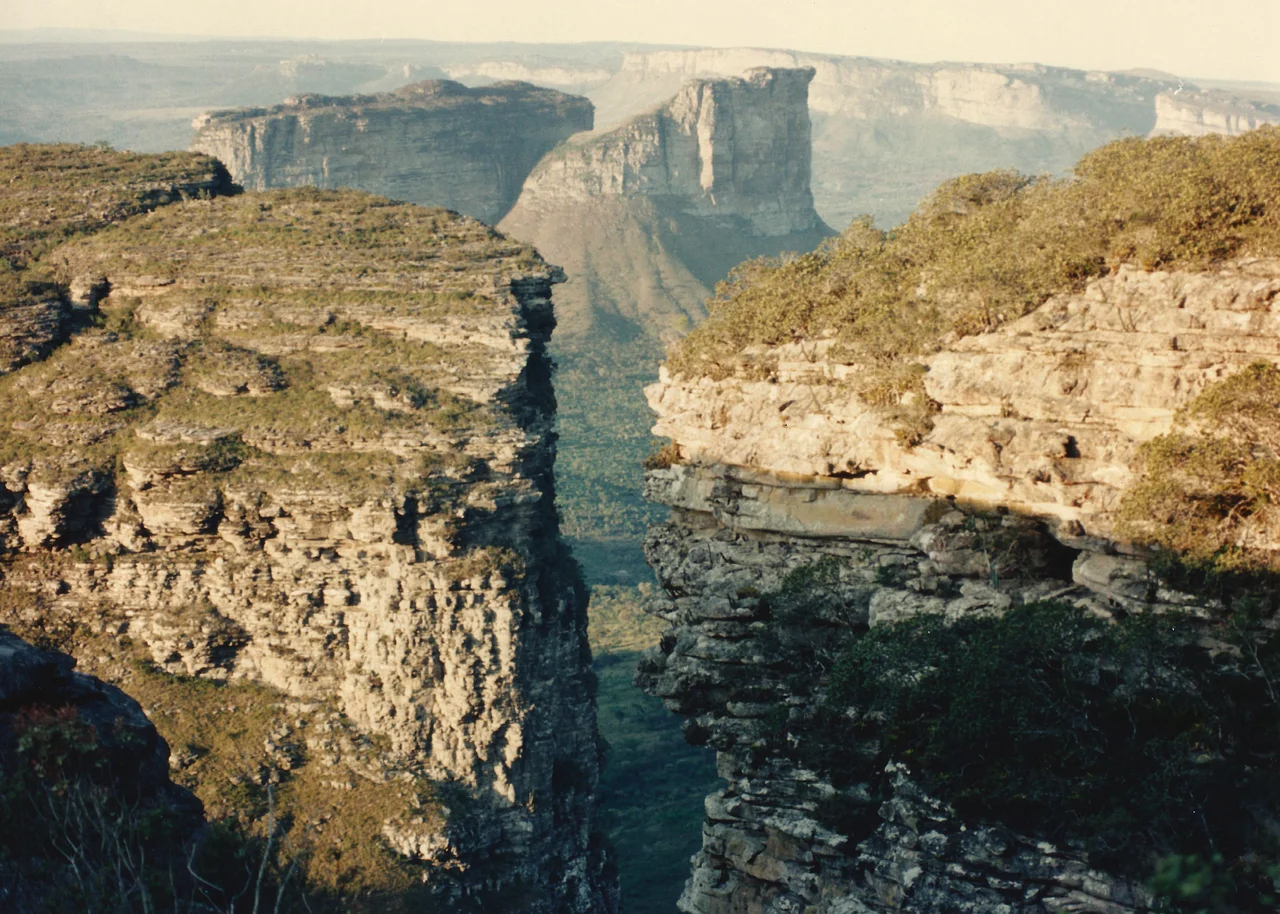
The plateau is technically an erosional landform - not a volcano, not a lifted block, but a stubborn leftover. Streams cut away at the softer Paraguacu Group sandstones below while the tougher Chapada Diamantina Group above holds its shape, producing the characteristic silhouette of flat summits and sudden cliffs. The Pai Inacio anticline, a 25-kilometer-wide arch exposed at the contact between the two rock groups, is essentially a cross-section of the plateau's history. Diamond-bearing conglomerates sit within that upper layer. For most of geological time this was boring news, but in the late eighteenth century prospectors learned which creeks to work, and the region's other name - the Lavras Diamantinas, the Diamond Washings - was born.
The Boom and What It Built
Diamonds had already been found in Minas Gerais by the 1720s, but the Bahian discoveries, beginning in earnest in the 1840s, drew a second wave of fortune-seekers northward. Lencois, which means "bed sheets" for the white tents of the miners' encampments laid across the hillsides, grew from nothing to become the commercial center of the region. Ornate townhouses went up along its cobbled lanes. A French consulate opened. Igatu, now a picturesque ghost town whose roofless stone houses line cobbled streets, was briefly a thriving mining village. The fortunes were made by a few and chased by many: most of the garimpeiros who did the physical work were poor Brazilians and, during the imperial period, enslaved Africans forced into the streams. The sparkle of the gems on European fingers was cut by the reality of who stood knee-deep in cold river water to find them.
Canyons, Caves, and the Country They Hold
Drive west from Lencois and the road climbs through Cerrado grassland to the Morro do Pai Inacio, a ship-prowed mesa whose summit view across the Vale do Capao is the region's signature image. South of here, the Vale do Pati - often called the best trekking route in Brazil - winds between sandstone walls past homesteads whose last families stayed when mining was banned. Further north, the town of Iraquara holds so many caves that locals call it the Cidade das Grutas, the City of Caves. The Gruta da Torrinha, the Gruta da Lapa Doce and others carry prehistoric rock paintings whose ages run into the thousands of years - evidence that people lived in this landscape long before the Portuguese, and long before the first diamond was spotted glinting in a stream.
After the Stones
Gold and diamonds still turn up occasionally, but industrial mining within the national park's boundaries has been forbidden since 1985. What replaced the gem economy was a slower, lighter thing: ecotourism. Lencois, 428 kilometers from Salvador by highway, receives a steady stream of hikers and climbers. Rock climbers have pioneered hundreds of routes around Vale do Capao and Igatu, working some of the same walls that prospectors once rappelled down on ropes. The high-altitude grasslands, called Gerais locally, still feel like a frontier - cool, windy, sparsely populated. At an average annual temperature under 22 degrees Celsius, the plateau is noticeably cooler than the lowland Bahia below, and for Brazilians escaping the coastal heat it offers something close to a different country inside the same one.
From the Air
Chapada Diamantina spans roughly 38,000 km² in central Bahia between latitudes 11 and 14 degrees south and longitudes 41 to 43 degrees west; the reference coordinate for the region is 12.88 S, 41.37 W. Typical plateau elevations 500-1,500 meters with isolated peaks above 2,000 meters. Best aerial views from 10,000 to 14,000 feet in clear morning or late afternoon light, when the mesas cast dramatic shadows. Nearest airports: Horácio de Mattos (SBLE) at Lençóis, Glauber Rocha (SBQV) at Vitória da Conquista, and Salvador Deputado Luís Eduardo Magalhães (SBSV) 428 km east. Thunderstorms common in summer afternoons; dust and smoke haze possible late in the dry season (Sep-Oct).
Nearby Stories
- Sincura 8.1 km away
- Lençóis 14 km away
- 1798 Revolt of the Alfaiates 20 km away
- Manuscript 512 148 km away
- Pé de Serra 157 km away
- São João de Deus Hospital 200 km away
- Morro de São Paulo 203 km away
- Caminho dos Gerais State Park 244 km away