
Charters Towers Mine Shafts
There is a chain-wire fence at the end of an ordinary street in Charters Towers, and behind it the ground simply stops. The shaft drops into darkness, its rock-lined collar cut straight down to a depth no torch could reach. Eight of these fenced openings survive among the houses and front lawns of the old goldfield, the last visible mouths of a vast underground world. Somewhere below your feet runs an estimated 200 kilometres of mine workings, the hollowed-out skeleton of one of the richest reefing fields Australia ever produced.
Gold in the Reefs
Charters Towers was never an easy goldfield. There was almost no alluvial gold here, no nuggets to be panned from a creek. The wealth lay locked in reefs of ore that sloped downward into the earth, splitting and looping as they went, and reaching it took capital, machinery and nerve. After gold was found at the foot of Towers Hill in late 1871 and the field was proclaimed in 1872, miners chased the lodes down through solid rock. By 1886, thirty-three shafts had already passed the 150-metre mark. The reefs carried evocative names, each one a small economy: the Day Dawn, struck in 1878, and above all the Brilliant Reef, the richest on the field, discovered in 1889.
The Money From London
The deeper the gold lay, the more money it took to chase, and soon the local syndicates could not keep up. In 1885 a display of Charters Towers ore at the Colonial and Indian Exhibition in London lit a fuse. British investors, dazzled by the assays, floated company after company on the London market and poured their wealth into a town most of them would never see. That outside capital built the substantial brick city that still stands today. It also meant the shafts in the suburbs were tied, by share certificate and telegraph cable, to boardrooms on the other side of the planet. At its peak the field accounted for more than a third of all the gold mined in Queensland.
Going Deeper
The numbers from these shafts still impress. The Day Dawn Block and Wyndham Company, working three connected shafts from 1883 to 1912, raised the greatest yield on the whole field: nearly 590,000 tons of ore for some 546,000 ounces of gold. When its workings were joined underground, rock drills were used successfully on the goldfield for the first time, the ground so hard that one contractor reportedly lost money on the job. The Brilliant Deeps went deepest of all, a three-compartment shaft sunk past 2,500 feet, with an underlie working reaching 2,615 feet. A dynamite explosion on Christmas Day 1896 wrecked its collar and threw thirty men out of work, and even at that depth, much of the ore proved not worth the lifting.
Hope and Disappointment
For every famous reef there were a dozen quiet failures, and the surviving shafts tell both stories. The New Queen Central worked five reefs from 1892 to 1916 and found that the rich ore of its neighbours simply did not extend onto its ground. The St George and Moonstone shaft, sunk in 1915 with a government subsidy, chased the Moonstone reef to 798 feet and found nothing; today its opening stands flooded with water to within a metre and a half of the surface. Sinking a shaft was a gamble repeated hundreds of times across the field, and the patchwork of leases that once covered the entire town is a map of both the spectacular strikes and the money that vanished into rock.
What the War Took
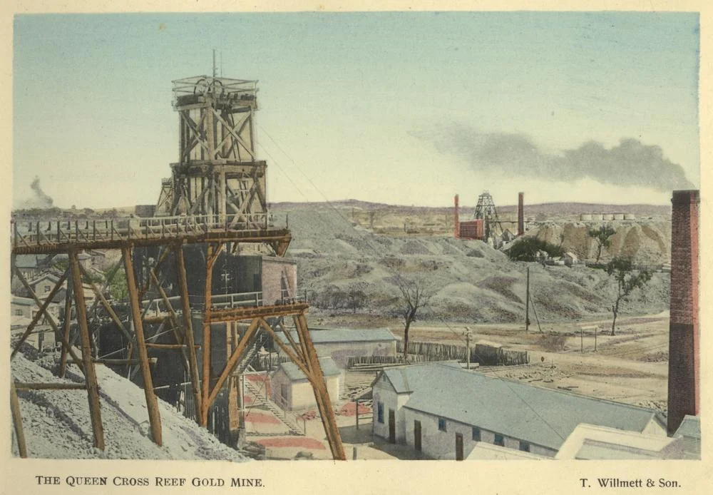
The decline came steadily after 1899. The number of working miners collapsed from 2,631 in 1910 to 985 just three years later, and people began to drift away. Most mines were abandoned by 1916, and the last of the great ones, the Brilliant Extended, closed in 1917. During the First World War, the headframes, poppet heads and machinery that once towered over the shafts were stripped away and recycled for the war effort, leaving the openings bare. In the 1960s the city council fenced what remained, and a program of capping continues today. Yet the gold below was never fully exhausted, and a modern company has resumed prospecting beside the old Brilliant Deeps, drilling once more toward the reef that made this city.
From the Air
The Charters Towers mine shafts are scattered through the town and its eastern suburb of Queenton, centred near 20.084 degrees south, 146.264 degrees east, in the dry inland country roughly 130 km south-west of Townsville. From the air the shafts themselves are too small to pick out, but the town's compact heritage grid, the bald rise of Towers Hill to the south, and the pale scars of old mullock heaps and workings around the edges of the suburbs are clear markers. A recommended viewing altitude is 2,500 to 4,500 feet AGL for the townscape. Charters Towers Airport (YCHT), at roughly 20.04 S, 146.27 E, lies on the north-eastern edge of town; Townsville Airport (YBTL) is about 102 km to the north-east. Expect excellent visibility in the dry season (April to October) over this open inland plateau; summer afternoons can bring haze and thunderstorms.
Nearby Stories
- Bindal People 44 km away
- Herveys Range Heritage Tea Rooms 57 km away
- Bowen River Hotel 65 km away
- Radar Station, Charlie's Hill 71 km away
- Strathmore Homestead 126 km away
- Porcupine Gorge 153 km away
- Undara Volcanic National Park 230 km away
- Lake Dunn 276 km away