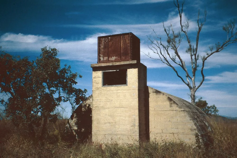

Radar Station, Charlie's Hill
From the top of Charlie's Hill you can see the whole flat sweep of the lower Burdekin: cane fields, the river's braided mouth, Rita Island and Peters Island offshore, and beyond them the open water of the Coral Sea. In 1943 that view was the whole point. The flat ground meant nothing was high enough to block a radar beam, and the Coral Sea was where the next Japanese aircraft might come from. So the Royal Australian Air Force put two reinforced-concrete bunkers and a pair of 186-foot timber towers on this hill and told a small unit of men and women to stare at the sky, in eight-hour shifts, around the clock.
Why North Queensland Mattered
For most Australians the Second World War feels like something that happened overseas. For North Queensland it arrived at the coastline. After Japan's declaration of war in December 1941, and the bombing of Darwin in February 1942 and Townsville that July, the northern coast suddenly became a front line. When the fighting moved into New Guinea in mid-1942, the region turned into a vast staging area, full of American and Australian troops moving north. Radar was the early-warning skin stretched along that coast. The RAAF built around twenty radar stations down the North Queensland shore, each meant to catch approaching aircraft while there was still time to scramble fighters or sound an alarm. No. 211 Radar Station went up on Charlie's Hill late in 1943.
A Rare Kind of Station
Most of those coastal stations were mobile or makeshift. Charlie's Hill was different. It was a 200-series fixed-ground "high flying" station, one of only two of its type in North Queensland, the other being No. 220 at Bones Knob near Tolga. It ran British Advanced Chain Overseas equipment in the high-frequency band at 42.05 megacycles per second, a wavelength of about seven metres, and it could measure not just the bearing of an aircraft but its height. Two timber towers, 186 feet tall and shipped in kit form, stood about a hundred metres apart carrying the transmitting and receiving aerials. The delicate electronics lived in two bomb-proof igloos of reinforced concrete, set roughly eighty metres apart on the summit, one for receiving and one for transmitting.
The Crew
A radar station is only as good as the people watching the screen, and the unit here was small, around thirty-five in all. The station ran 24 hours a day in three shifts. Each shift was just three or four people: one operating the set, one at the plotting table, one recording the messages coming in, and one working the telephone. To break the monotony of staring at a glowing trace, they rotated jobs every two hours. The work was shared between RAAF airmen, who lived on site, and members of the Women's Auxiliary Australian Air Force, who served as operators, plotters and recorders. The WAAAF women worked the daylight shifts and were billeted in the hotel down in Home Hill, cycling or being driven up to the hill and back.
Inside the Igloos
The two igloos were cleverly built for a place that expected to be bombed. Each is a low, semi-circular vault of reinforced concrete, about ten metres long and six wide, with a short tower at one end. The towers doubled as ventilation: fans drew fresh air in through the front and exhausted it up the tower, no small thing in tropical heat with equipment running constantly. The receiving igloo's doorway was staggered like an S-bend, so that someone could walk in and out without any light spilling from inside to betray the position at night, while the same baffled entry kept air flowing through. The transmitting igloo still shows the holes in its concrete floor where the aerial cables ran out to the towers. A camp of huts, mess and toilets, and a diesel generator sat at the base of the hill on the northwestern side.
What the War Left
Japan surrendered in August 1945, and the North Queensland defences were stood down. Charlie's Hill stopped operating on 1 October 1945, its equipment dismantled and carried away. Before they left, the officers and operators threw a thank-you for the people of Home Hill: a tennis afternoon, then dinner and a dance in town, a small grace note at the end of a hard posting. What remains is unusually complete. Both concrete igloos still stand, along with two spotter's posts, chest-high concrete-lined holes where Voluntary Air Observers' Corps members confirmed radar contacts by eye, and the square footings of both timber towers. The Burdekin community has looked after the site as a quiet, view-rich memorial to a coast that once held its breath.
From the Air
Charlie's Hill Radar Station sits at 19.71 degrees south, 147.46 degrees east on a low hill near Inkerman, just south of Home Hill and the Burdekin River in coastal North Queensland. From the air the hill stands out as a small rise above flat sugarcane country, with Rita Island and Peters Island visible to the northeast where the Burdekin meets the Coral Sea; the two concrete igloos and tower footings sit on the summit. The nearest major airport is Townsville (ICAO YBTL), about 90 km to the north-northwest. The site is best viewed at 1,500 to 3,000 feet AGL; the lower Burdekin offers clear coastal flying in the dry season, with tropical haze, humidity and storm cells common during the November-to-April wet.
Nearby Stories
- Imperial Hotel, Ravenswood 9.5 km away
- SS Gothenburg 17 km away
- Stewart's Creek Gaol 21 km away
- SS Yongala 28 km away
- Bowen 36 km away
- Ravenswood School of Arts 37 km away
- Strathmore Homestead 53 km away
- Proserpine 72 km away