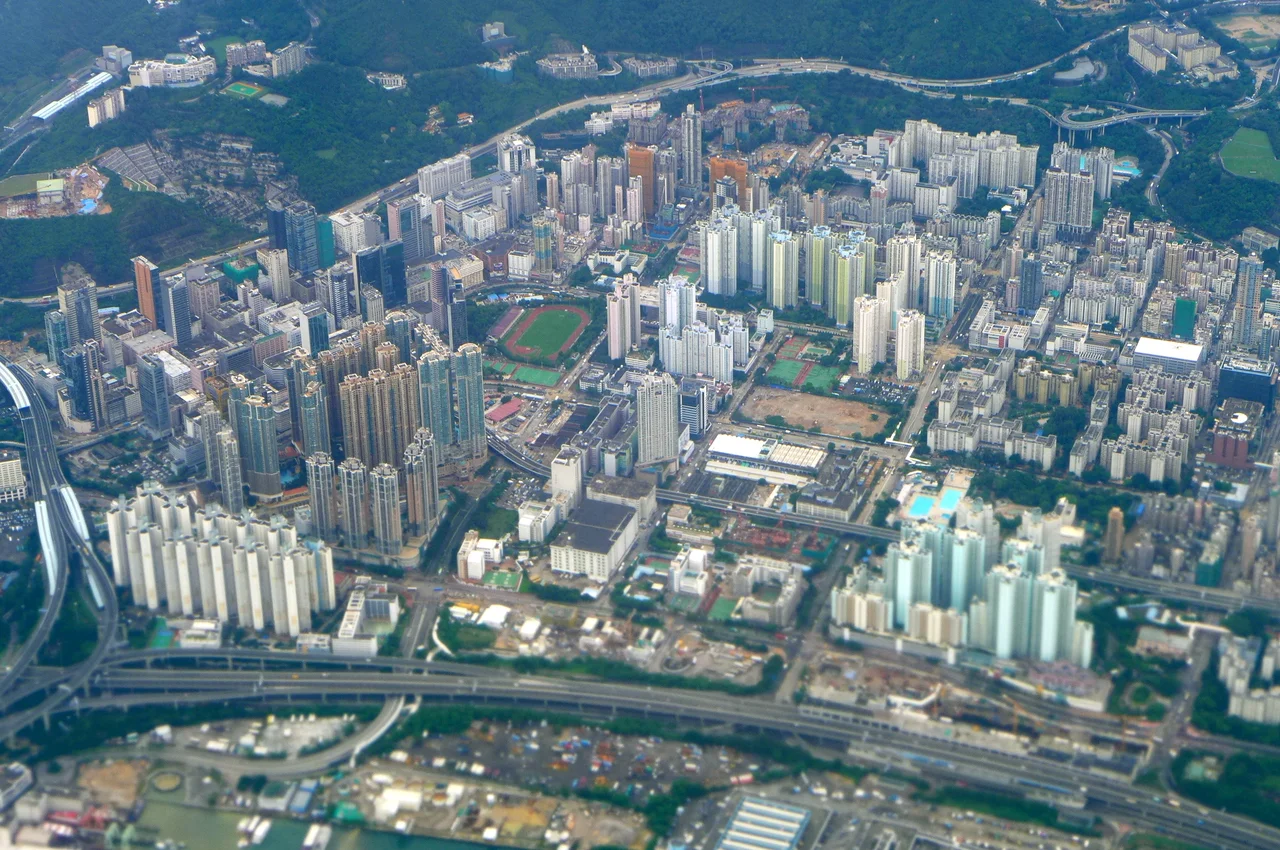

Cheung Sha Wan
The name means 'Long Sandy Bay,' and for centuries that's exactly what it was — a curving beach where Tanka fishing families kept their boats and river plains backed up against the hills of Beacon Hill and Crow's Nest. Today that shoreline is buried under Castle Peak Road and Un Chau Street, the original coast fossilized beneath decades of reclamation. Cheung Sha Wan no longer has a beach. What it has instead is a Han dynasty tomb, a cluster of skyscrapers nicknamed the Four Little Dragons, and a wholesale clothing market that supplies half of Hong Kong's fashion trade.
Two Thousand Years Under the Surface
The Lei Cheng Uk Han Tomb is the oldest known constructed structure in Hong Kong, built sometime between AD 25 and 220 during the Eastern Han dynasty. Its presence in Cheung Sha Wan — now a densely built Kowloon neighborhood — is a reminder that Chinese civilization had extended into this peninsula two millennia before the British arrived. The tomb is preserved in a museum on Tonkin Street, a vault-shaped brick structure of a type common in the Han heartland, built by someone wealthy enough to warrant a proper burial far from the imperial center.
The neighborhood has been disgorging its past in other ways too. In April 2006, workers unearthed 588 unused artillery shells at Tonkin Street — ammunition left by Japanese forces during their occupation of Hong Kong from 1941 to 1945. Residents were temporarily evacuated while the shells were detonated safely. The ordnance had been buried for over sixty years, a reminder that the ground under Kowloon still holds the residue of wartime occupation.
The Beach That Became a City
Before the First World War, Cheung Sha Wan was still largely rural: small villages with names like Om Yam, Ma Lung Hang, Pak Shu Lung and Wong Uk scattered behind the shoreline. Rivers from the hills formed a long coastal plain, a sandbar marked the estuary of Butterfly Valley, and the census of 1911 counted just 653 residents, 496 of them male — a fishing and farming community at the edge of Kowloon.
Reclamation proceeded in phases through the twentieth century. By the time the last major reclamation extended the area toward Stonecutters Island in the 1990s, the bay had been entirely consumed. Shipbuilding and repair yards that had worked the old shoreline relocated near the island; their vacated land became the residential towers that now define the western Kowloon skyline. Villages and beaches became urban grid, the bay itself transformed into dry land that now holds apartment towers of up to 197 meters.
Manufacturing, Markets, and the Mainland Shift
After 1945, Cheung Sha Wan became one of Hong Kong's primary manufacturing zones, its industrial buildings filled with textile mills and garment factories feeding export markets in Europe and North America. The area's light industries made Hong Kong one of the world's leading clothing exporters through the 1960s and 70s.
When China opened to foreign investment in the 1980s, the economics shifted overnight. Factories relocated across the border to the Pearl River Delta, where land and labor costs were a fraction of Hong Kong's. Industrial buildings emptied out, some converted to offices and warehouses. What remained in Cheung Sha Wan was the wholesale trade: several large markets dealing in fresh produce, poultry, and especially clothing. The Cheung Sha Wan Vegetable Wholesale Market, the wholesale poultry market, and a dense cluster of fabric and fashion wholesale shops still draw buyers from across Hong Kong and beyond. The head office of Giordano — one of Asia's largest casual-wear retailers — occupies the Tin On Industrial Building here.
The Four Little Dragons
When the shipyard land reclaimed from the West Kowloon Reclamation was released for development in the early 2000s, developers filled it with a quartet of residential towers nicknamed the 'Four Little Dragons of West Kowloon.' The name echoes Hong Kong's own nickname as one of Asia's tiger economies, scaled down to a block of four neighboring megacomplexes.
The Pacifica's six towers each rise 197 meters and 50 to 66 floors, completed in 2006. Banyan Garden's tallest towers reach 191 meters. Liberté's towers reach up to 181 meters, five of them among the hundred tallest buildings in the territory. Aqua Marine, a collaboration between Hang Lung Properties and Hyundai Engineering and Construction, completed in 2003. Together the four complexes remade the waterfront, replacing industrial wasteland with a high-density residential district that looks from the harbor like a wall of glass and concrete, a skyline assembled almost overnight from land that didn't exist a generation earlier.
A Name That Migrated
The administrative geography of Cheung Sha Wan has long defied casual understanding. The area sits within Sham Shui Po District, not a Cheung Sha Wan district of its own. Two MTR stations serve the neighborhood on the Tsuen Wan line: Cheung Sha Wan station to the east and Lai Chi Kok station to the west. Lai Chi Kok station is not, in fact, located in Lai Chi Kok — it sits in Cheung Sha Wan. Signs referencing Cheung Sha Wan appear on buildings and bus stops all around what the maps call Lai Chi Kok, a persistent source of confusion for visitors and newcomers.
The Cantonese name itself carries a tonal quirk: the character that would normally carry a high-flat tone shifts to a low-falling tone in this particular compound, the same shift that occurs in the names To Kwa Wan and Causeway Bay. A small linguistic fossil, embedded in daily speech, of a bay that no longer exists.
From the Air
Cheung Sha Wan is centered at approximately 22.336°N, 114.150°E, on the western coast of the Kowloon Peninsula. From 2,000–3,000 feet, the neighborhood's skyline is defined by the clustered towers of the Four Little Dragons residential complexes along the reclaimed waterfront, easily visible against Stonecutters Island and the broader West Kowloon reclamation. The Tsing Ma Bridge and Lantau Island are visible to the west. Nearest airport: VHHH (Hong Kong International Airport) approximately 22 km southwest via the harbor. Stonecutters Island — visible as a large green landmass now connected to Kowloon by reclamation — provides clear navigation reference.
Nearby Stories
- Chapel of St. Francis Xavier 3.5 km away
- Cuiheng 4.1 km away
- 2015 Shenzhen Landslide 16 km away
- Shunde 31 km away
- Wanshan Archipelago 37 km away
- Nanxiong Formation 96 km away
- Heyuan 149 km away
- Checheng Fu'an Temple 629 km away