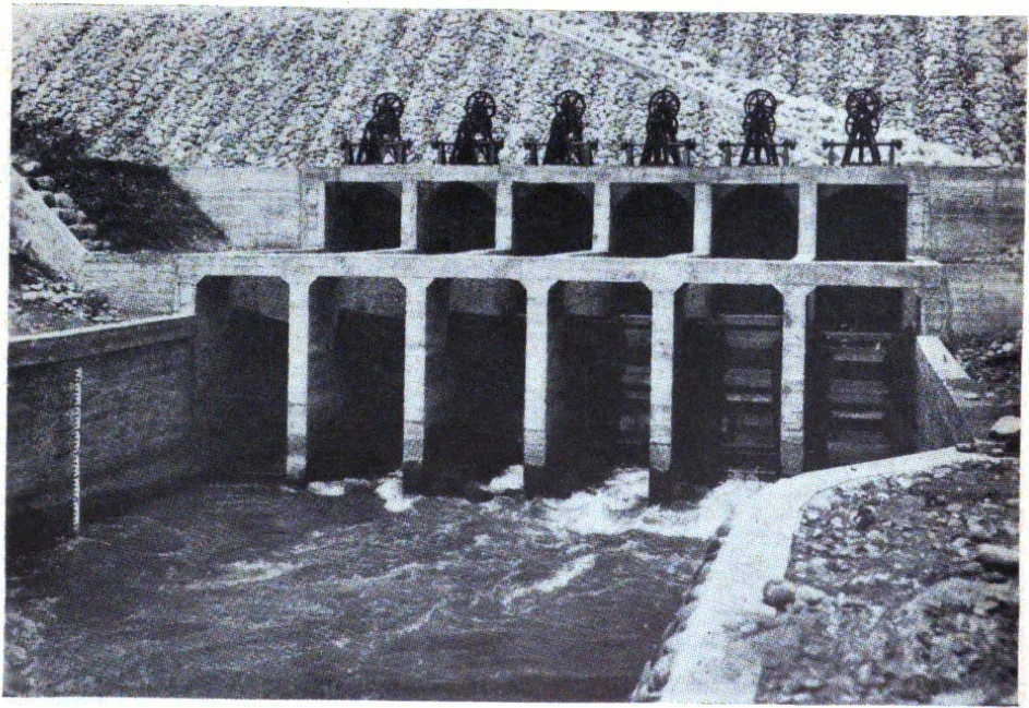

Chianan Irrigation
Before Yoichi Hatta arrived, the Chianan Plain was largely a dry gamble. Farmers on the flat expanse between Chiayi and Tainan depended on seasonal rainfall that was unreliable, and the land — though fertile — produced modest yields that could not sustain a large population. Hatta, a civil engineer working under the Japanese colonial government, looked at the same landscape and saw a different future: a network of canals threading through 150,000 hectares, fed by a reservoir in the hills, turning a marginal plain into one of the most productive rice-growing regions in Asia. He spent a decade building it.
The Engineer and the Plain
The name Chianan collapses two place names into one: Chiayi to the north and Tainan to the south, the two poles of the administrative region that would be transformed. The plain between them is low, flat, and crisscrossed by rivers that flood erratically. Reliable irrigation had been attempted before, but nothing at the scale that Hatta proposed.
Construction on the Chianan Canal system began in 1920. The project included not just the canals themselves but associated infrastructure — most significantly the Wusanto Reservoir, which stored the water that would be distributed across the system. For ten years, workers moved earth and stone across a landscape that offers few natural features to anchor large civil engineering works. The canals needed to be precisely leveled to move water by gravity across a terrain where the grade changes almost imperceptibly. Hatta coordinated all of it.
The Numbers That Transformed an Island
The system was completed in 1930, and the transformation it wrought was immediate and measurable. Before the canals, the plantable area for rice on the Chianan Plain stood at approximately 5,000 hectares. After the canals, that figure rose to 150,000 hectares — a thirty-fold increase. The irrigated fields could now support three rice harvests annually in the warmest parts of the system, compared to one or at most two before.
The implications ran far beyond agriculture. Rice surpluses fed Taiwan's population through the mid-twentieth century, supported exports, and provided the material basis for urban growth in Chiayi and Tainan. A canal network does not announce itself as dramatically as a bridge or a dam, but the Chianan system's effect on the lives of the people who farmed these plains — and on the population density and economic development of an entire region — was as consequential as any engineering project in Taiwan's modern history.
Water Moving Through Three Counties
The main streams of the Chianan system pass through what are today three separate administrative units: Tainan City, Chiayi County, and Yunlin County. During the Japanese colonial period, these were all part of a single Tainan Prefecture, which simplified administration but still required coordinating water distribution across a vast and complex network of primary, secondary, and tertiary canals.
The canal runs parallel to some of the region's major rivers — the Peikang River to the north, the Tsengwen River to the south — without following them. It is an engineered system superimposed on the natural hydrology of the plain, rerouting water from elevation toward flatness in a controlled and predictable way that the rivers themselves cannot provide. The result is a landscape that looks, from above, like a green grid: paddies stitched together by the narrow lines of irrigation channels running in disciplined geometries across the land.
Legacy and Recognition
In 2009, Taiwan nominated the Chianan Irrigation system as a potential World Heritage Site under UNESCO guidelines — an acknowledgment that what Hatta built represents not only a feat of engineering but a cultural landscape. The system is not simply infrastructure; it is the physical structure of an agricultural civilization that grew up around it. The paddies, the canal banks, the control gates, the reservoir — together they form an environment that shaped how people lived and worked on the Chianan Plain for nearly a century.
Yoichi Hatta himself is remembered with unusual warmth in Taiwan, where his statue stands near the Wusanto Reservoir. He died in 1942, and his wife, unable to bear the news, walked into the very reservoir he had built. Their devotion to this landscape — one by engineering, one by grief — became part of the story the plain tells about itself.
From the Air
The Chianan Irrigation system spans a broad region centered at approximately 23.60°N, 120.36°E, covering the agricultural plains of Tainan, Chiayi, and Yunlin counties. From the air at 8,000–15,000 feet, the system reveals itself as a network of straight and curved canal lines cutting across the green paddy landscape, particularly visible during the growing season when fields are flooded. The Wusanto Reservoir appears as a blue feature against the hills to the east. Nearest airport is RCKU (Chiayi Airport), approximately 15–20 km north of the system's center; RCNN (Tainan Airport) lies to the south.
Nearby Stories
- Puli 7.3 km away
- Guanzihling 11 km away
- Fangyuan Lighthouse 11 km away
- Yakou Mountain Pass 13 km away
- 1999 Jiji Earthquake 15 km away
- China Airlines Flight 611 23 km away
- TransAsia Airways Flight 222 26 km away
- Dongji Island 26 km away