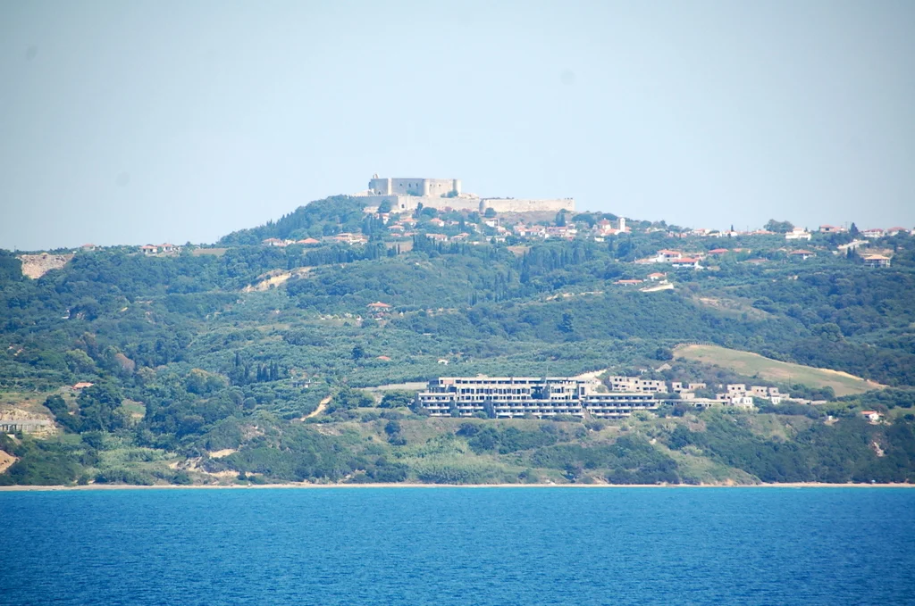

Chlemoutsi
Geoffrey I of Villehardouin needed money to build a castle, and the Church of Achaea had it. When the clergy refused his request for military donations — citing their allegiance to the Pope alone — Geoffrey confiscated their lands and properties. With those funds, between 1220 and 1223, he built Chlemoutsi on a plateau 226 meters above the Elian coast. It was an act of appropriation that became architecture, and the architecture has outlasted every grievance.
Fortress Born of Dispute
The Principality of Achaea was a Frankish state established after the Fourth Crusade, controlling the Peloponnese peninsula — the Morea, in medieval usage. Geoffrey I of Villehardouin ruled it at its height, and Chlemoutsi was his flagship project. The castle occupied a new foundation with no prior structure on the site, and its French name — Clairmont or Clermont — almost certainly gave rise to the Greek Chlemoutsi through phonetic drift over generations.
The fortress stood at the operational heart of the Principality: the princely capital of Andravida lay 13 km to the east, and the chief port of Glarentza was only 5 km to the northwest. Together with a smaller fortress at Katakolo to the south, these four points secured control over the fertile plain of Elis, the wealthiest part of the princely domain. Despite this strategic significance, Chlemoutsi was never once besieged throughout the Principality's history. Its function, it turned out, was largely as a prison.
A Hexagonal Keep and Eight Centuries
The heart of Chlemoutsi is an irregular hexagonal keep, roughly 90 meters east-to-west and 60 meters north-to-south, enclosing a central courtyard. Around that courtyard, two-storeyed halls run along the entire interior perimeter — their upper galleries vaulted in ovoid barrel vaults of poros ashlar that the architectural historian Kevin Andrews described as "immaculate." The lower storeys opened into the courtyard through arches; the wooden floors that separated the two levels have long collapsed, but the beam-support niches remain.
The galleries exhibit what Andrews called "stylistic uniformity" — double-arched windows in vaulted recesses, banquettes on either side, niches and fireplaces matching those in the outer curtain wall. The castle was built quickly and consistently, probably within three years. Most elements derive from French 12th-century architectural tradition; as Andrews noted, it is a transitional Romanesque rather than Gothic structure, with only scattered Byzantine touches — certain impost blocks, some local stone. An outer ward to the west, enclosed by a curtain wall of irregular polygonal outline, protected the more accessible western approach.
Princes, Prisoners, and Palaiologoi
The castle's roster of notable prisoners is long. In around 1263, Byzantine generals captured at the Battle of Makryplagi were held here; one, Alexios Philes, died in captivity. In the 1290s, Thomas Komnenos Doukas, son of the Despot of Epirus, was kept at Chlemoutsi as a hostage for his father's compliance. Margaret of Villehardouin — who had schemed to reclaim the Principality through a Majorcan marriage alliance — died here in March 1315 after being imprisoned by the Angevin bailli.
After the Villehardouin line ended and Angevin control gave way to various claimants, Chlemoutsi changed hands repeatedly. In 1427, it was ceded to the Byzantine Despot of the Morea, Constantine Palaiologos — the man who would become the last Byzantine emperor. He used it as his residence and his base for operations against Patras in 1428–30. The Ottomans took it in 1460 along with the rest of the Morea, made some artillery modifications, and watched it slowly empty. By the early 19th century it stood completely deserted.
Ibrahim Pasha's Cannons and What Survived
In 1825, during the Greek War of Independence, the Egyptian forces of Ibrahim Pasha occupied Chlemoutsi and demolished a portion of its outer wall to deny the structure to Greek rebels. The breach is still visible in the southern wall, where later Turkish repairs — broken tiles alternating with stone courses — mark the damage done. The southwestern tower is almost entirely ruined as a result.
Everything else is essentially there. The Venetians, who held the castle during the Ottoman-Venetian War of 1463–79 and again during the Morean War period of 1687–1715, made no significant changes. One Venetian governor in 1701 even recommended destroying the place, finding it too small and too far from the sea to be useful. It wasn't destroyed. The Ottomans added artillery platforms at the southwest corner, replaced the original outer gate arrangement, and built some crenellations — all of which scholars can identify and date because the Frankish original is so clearly preserved around them.
The View from 226 Meters
Standing on the roof terrace of the keep, the view extends across the Elian plain to the Ionian Sea, with the islands of Zakynthos and Cephalonia on the horizon and, in clear conditions, the mainland coast of Aetolia-Acarnania beyond. The castle's setting — steep drops on the south, east, and north; a gentler slope only on the west toward the modern village of Kastro-Kyllini — explains why it needed no towers on its most exposed sides. The terrain was the defense.
The medievalist Antoine Bon called Chlemoutsi "the most beautiful testimony of the military art in the Frankish principality." That assessment has held. Today the castle is protected under the 6th Ephorate of Byzantine Antiquities and is open to visitors, reached easily by car from the nearby village. Italian sources from the 15th century onward called it Castel Tornese, confusing it with the nearby mint at Glarentza that struck silver tornese coins. The name stuck in some traditions, but the structure it names remains, precisely and unmistakably, Frankish.
From the Air
Chlemoutsi sits at 37.8903°N, 21.1419°E, on a plateau 226 meters above sea level near the village of Kastro-Kyllini, on the northwestern coast of the Peloponnese. From the air at 3,000–5,000 feet, the hexagonal keep is clearly distinguishable against the surrounding plateau, especially in low sun when its limestone walls catch the light. The Ionian Sea and the islands of Zakynthos and Cephalonia are visible to the west and southwest. Glarentza's site on the coast lies approximately 5 km to the northwest. The nearest major airport is LGRX (Araxos), approximately 30 km to the north-northeast. Altitude recommendation: descend to 2,000–3,000 feet for the best view of the castle's plan and curtain walls.
Nearby Stories
- Astras 4.5 km away
- Heraea (Arcadia) 5.3 km away
- Battle of Lepanto 6.7 km away
- Ionian Islands 9.7 km away
- Saint Gerasimos Monastery 14 km away
- Alpheus (deity) 16 km away
- Salmeniko Castle 19 km away
- 2018 Ionian Sea Earthquake 20 km away