Cihou Fort
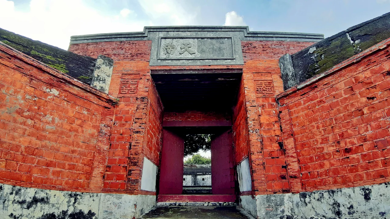
A Chinese inscription once adorned the southern gate of Cihou Fort. It read "Mighty Blow to the South," a boast carved in stone by the Qing officials who built the battery to defend Kaohsiung Harbor. In October 1895, the Japanese cruiser Yoshino put a shell through the gate and blew the characters for "mighty blow" clean off the wall. The rest of the inscription survived, and it still stands there today, an ironic fragment of a promise that could not be kept. Cihou Fort has been making and breaking such promises since 1720.
Three Centuries on the Hill
The first fortifications appeared in 1720, when Taiwan was governed by the Manchu-led Qing dynasty. For more than a century the position was adequate against the threats it faced, but the Japanese expedition of 1874 convinced Qing authorities that modern defenses were needed. They commissioned a British engineer named H. W. Harwood to design a proper fort, and by 1880 the battery was armed with new Armstrong guns. The structure Harwood built consists of three parts: fortified barracks arranged around a rectangular courtyard with a defensive parapet on the roof, a central command post, and the main rectangular battery with four open emplacements for seven-inch Armstrong rifled muzzle-loaders. Ammunition magazines sit on a lower level, and the steep natural slopes of Cihou hill serve as the fort's scarps, making assault from below a daunting prospect.
The Battle That Was Over by Lunch
Despite its modern armament, the fort played no role in the Sino-French War of the 1880s, when fighting in Taiwan concentrated around Keelung to the north. Its test came instead from Japan. After the Treaty of Shimonoseki ceded Taiwan to Japan in 1895, local troops refused to accept the transfer and fought on. On October 12, an Imperial Japanese Navy squadron under Admiral Arichi Shinanojo arrived at Takow, the old name for Kaohsiung, and ordered all foreigners to evacuate. The next morning at seven, Japanese ships opened fire on the forts at a range of about six thousand yards. For the first half hour the forts replied, firing twenty-four rounds in all. The best shot came from the eight-inch Armstrong guns at nearby Apes' Hill fort, striking the water about five hundred yards from the cruiser Naniwa. Then the guns fell silent. Japanese troops seized both forts in the early afternoon without suffering a single casualty. Four Chinese soldiers were killed.
Abandonment and Revival
The Japanese had no use for the fort during their fifty years governing Taiwan, and it sat empty. After World War II, the Republic of China army reoccupied the hill and cut light gun and machine gun nests directly into the rock, Cold War-era additions that can still be found among the older brickwork. The nineteenth-century fortifications at the foot of the hill have mostly crumbled away, but the upper battery, with its open emplacements overlooking the Taiwan Strait, remains intact. Today Cihou Fort is a designated national monument and one of Kaohsiung's most visited historic sites. Visitors climb the hill through Cijin District, the narrow barrier island that separates the harbor from the open sea, and find themselves standing behind the same parapets where Qing gunners once aimed their Armstrongs at an approaching fleet. The view sweeps across the harbor mouth and out to the strait. It is, as it was designed to be, a commanding position.
The Gate's Last Word
What makes Cihou Fort memorable is less its military record than what it reveals about Taiwan's layered history. Qing engineers built it, a British designer planned it, Armstrong guns from England armed it, and Japanese shells dismantled its boast of southern might. Republic of China soldiers carved their own fighting positions into the same rock. Each sovereign power left its mark and moved on. The fragment of inscription above the southern gate is the fort's truest artifact: a half-finished declaration of strength, undermined by the very history it tried to proclaim, yet still legible after more than a century of typhoons, wars, and changing flags.
From the Air
Coordinates: 22.613N, 120.264E, on Cijin Island at the northern entrance to Kaohsiung Harbor. The fort is visible on the hilltop overlooking the harbor mouth. Nearest major airport: RCKH (Kaohsiung International Airport), approximately 10 km southeast. Viewing altitude: 1,500-3,000 ft for the harbor and island geography.
Nearby Stories
- Taimali 7.2 km away
- Meinong East Gate Tower 15 km away
- Kunci Temple 20 km away
- Checheng Fu'an Temple 42 km away
- Dongji Island 49 km away
- Orchid Island 69 km away
- South Penghu Marine National Park 77 km away
- Hong Kong 12 549 km away