
Cowal
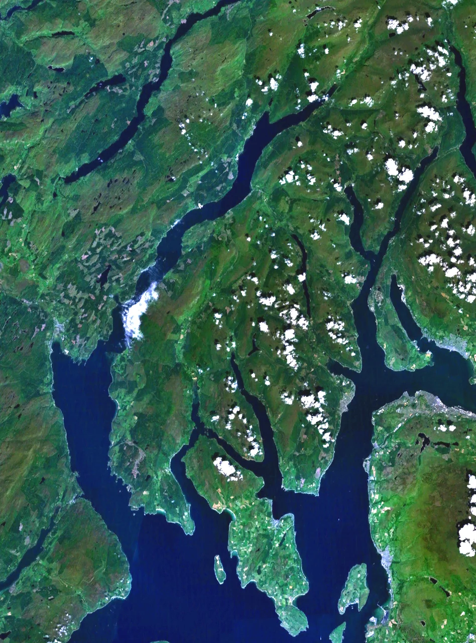
Look at a map of western Scotland and Cowal jumps out as something strange. It is a peninsula clearly attached to the mainland, but only barely. The sea has cut so deeply into it from three sides that the southern half splits into three knuckled forks separated by long fjord-like lochs. The Kyles of Bute curl around its southern tip; Loch Fyne hems it in to the west; Loch Long and the Firth of Clyde slice down its eastern flank. There are no railways and there never have been. To reach Cowal from Glasgow you go up and over the Rest and Be Thankful, or down and across the water by ferry. It is, in every practical sense, an island that just happens to share a thin neck of mountains with the mainland.
A Name Older Than the Map
The name Cowal is the inheritance of a vanished kingdom. When Gaelic-speaking settlers from Ireland crossed the sea in the early medieval period, they formed the kingdom of Dal Riata across what is now Argyll. Within Dal Riata, a kin group called the Cenel Comgaill held this peninsula, and over the centuries Comgaill softened into Cowal. Older still, this corner of Scotland may have belonged to the Pictish kingdom of Fortriu, though only archaeology speaks for that era now. Bronze Age cairns survive in the high ground: at Creag Evanachan above Loch Fyne, a mound roughly 20 metres across still marks burials laid down between 2000 and 800 BC. The land has been used and named and reused for at least four thousand years.
Three Forks and a Spine of Mountains
The northern third of the peninsula belongs to the Arrochar Alps and Argyll Forest Park, the latter established in 1935 as one of Britain's earliest forest parks. The highest point in Cowal is Beinn Ime in the Arrochar group at 1,012.2 metres, with Beinn an Lochain not far behind at 901.7 metres overlooking Loch Restil. From north to south the peninsula stretches roughly 32 miles, from the Rest and Be Thankful pass down to Ardlamont Point. At its widest it is some 17 miles across. The flat ground is all coastal, and so are nearly all the villages, strung along the shores of sea lochs whose interiors are too steep for towns. Dunoon, on the southeast, is the only burgh. Almost everything else is a hamlet or a single-loch cluster of houses.
Lamonts, Campbells, and a Massacre
The medieval clan map of Cowal traces back to an eleventh-century marriage between an heiress of the Cenel Comgaill and Anrothan, a grandson of an Ulster king. From his descendants came the MacLachlans at Castle Lachlan on the Loch Fyne shore, the MacEwens at Castle MacEwen in Kilfinan, and Clan Lamont, who held the south of the peninsula from Toward Castle. The Campbells arrived from Loch Awe and grew steadily more powerful. In 1646, during the Wars of the Three Kingdoms, the Campbells took revenge on the Lamonts for earlier reverses, overran Toward Castle, and after offering hospitality killed many of the Lamont occupants. Even after the chief surrendered, the Campbells hanged a large number of clan members in what became known as the Dunoon massacre. A memorial on Tom-A-Mhoid Road in Dunoon, dedicated in 1906, names the dead.
Doon the Watter
Steam power changed Cowal more than any clan war. After the PS Comet entered service in 1812, paddle steamers from Glasgow's Broomielaw turned the Clyde into a holiday corridor. By the late nineteenth century thousands of Glaswegians went doon the watter to Dunoon, Tighnabruaich, and dozens of pier-stops in between. Many of those piers are gone now. The Caledonian MacBrayne passenger ferry still runs from Dunoon to Gourock; Western Ferries carries cars from Hunters Quay to McInroy's Point. Smaller crossings link Colintraive to Bute, taking just five minutes across a 400-yard strait, and Portavadie to Tarbert across Loch Fyne. The annual Cowal Highland Gathering, held in Dunoon since 1894, still draws pipers and dancers from around the world. The Loch Lomond and Cowal Way, a long-distance footpath of more than 57 miles, threads the whole peninsula together for walkers.
From the Air
Cowal occupies roughly 56.0 north, 5.13 west, with the Rest and Be Thankful pass marking its northern boundary near 56.22 north. From altitude it reads as a three-fingered peninsula divided by Loch Striven and Loch Riddon to the south and bounded by Loch Long and Loch Fyne. EGPF Glasgow lies about 30 to 40 nautical miles east; EGPK Prestwick is roughly 45 nautical miles south. Recommended viewing altitude 4,000 to 6,000 feet for the full peninsula shape; the Arrochar Alps in the north regularly carry low cloud and require careful terrain awareness.
Nearby Stories
- Loch Katrine 3.4 km away
- Dumbarton 4.4 km away
- Easdale 5.1 km away
- Stewarton 5.9 km away
- Gigha 9 km away
- Loch Awe 9.4 km away
- HMS Dasher (D37) 12 km away
- Jura, Scotland 13 km away