Dorestad
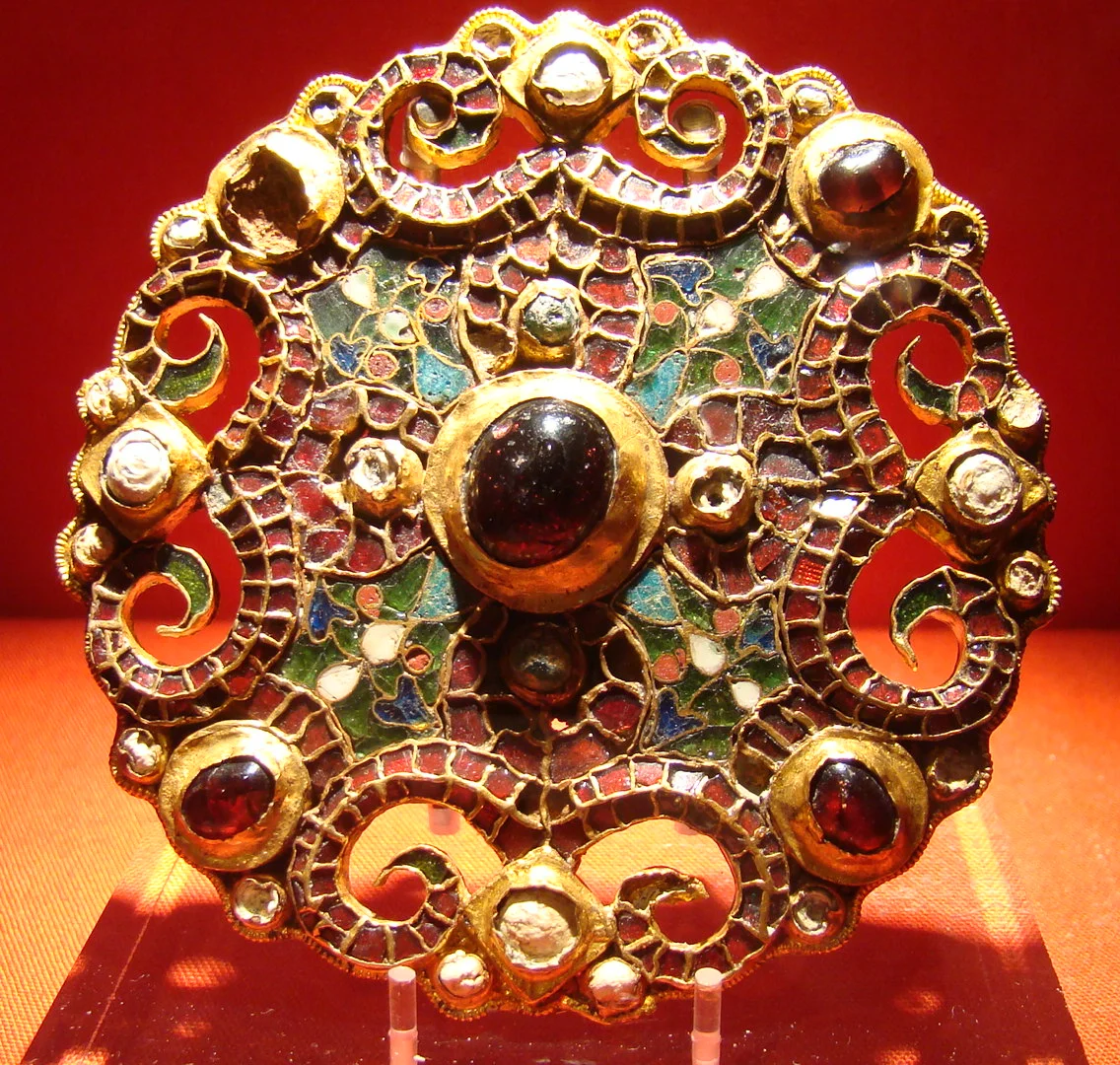
In 1969, a workman digging in a Dutch field near Wijk bij Duurstede uncovered a gold fibula at the bottom of an old well. The jewellery was Carolingian, ninth-century, exquisite - the kind of piece a wealthy trader might wear pinned at the shoulder. Archaeologists think someone dropped it down the well on purpose, hoping to return for it later. They never did. The fibula had been hidden, most likely, while Vikings burned the wealthiest port in northwest Europe to the ground.
Where the Rhine Forks
The geography made Dorestad inevitable. Here, just southeast of modern Utrecht, the Rhine splits into branches that fan out toward Germany, the North Sea, England, and Scandinavia. A boat that could reach this fork could reach almost anywhere in the early medieval world. The Romans had already noticed the strategic value - a fortress called Levefanum stood here, and centuries later Dorestad's builders quarried its tufa blocks for their own houses. By the seventh century a Frisian and Frankish trading town had grown up around the river junction. By the eighth, it was one of the largest settlements in northern Europe, sprawling across roughly three square kilometres in an age when most towns barely filled a few hectares.
The Emporium
Excavations between 1967 and 1977 exposed about 30 hectares of what archaeologists now call an emporium - a designation reserved for the great trading hubs of the early Middle Ages. Dorestad had a Lower Town along the harbour, an Upper Town where royal administrators and the mint were thought to operate, and farmland stretching inland. Frankish kings stamped their coins here. Wine arrived in barrels from the Rhineland. Lava querns from the Eifel came downriver to grind Frisian grain. Glassware travelled in both directions. The Franks took the town from the Frisians in 719 and never quite let go, taxing the trade, watching the wharves, and eventually handing oversight to the Church of Utrecht when imperial attention drifted elsewhere.
The Raids
The first Viking attack came in 834. The last came in 863. In between, the Danish longships returned again and again - drawn by Dorestad's wealth, and quietly encouraged, the sources suggest, by Lothair I, the rebellious eldest son of Louis the Pious. Lothair had been exiled to Italy after one of the family's many succession quarrels, and burning his father's richest port was a useful way to make a point. He ordered Harald the Younger, nephew of the exiled Danish king Harald Klak, to render Frisia ungovernable. By the time Louis and Lothair patched things up at Worms in 839, Dorestad had been sacked repeatedly. Lothair then gave the broken town to Harald and his brother Rorik to rule - the raiders inheriting what was left of their prize.
What the River Took
The Viking attacks did not, by themselves, kill Dorestad. The deeper trouble was that the Rhine was shifting. Silt clogged the channel. The harbour stopped expanding by the 830s and the river slowly migrated away from the wharves, leaving the lower town stranded from the water that had made it. Regional trade hubs were also multiplying across Francia, eroding Dorestad's monopoly on long-distance luxury goods. Coins continued to be minted for a while - habit outlasting commerce - and then the mint fell silent. By the late ninth century the site was empty. The English scholar Alcuin had already mocked the place a hundred years earlier in a sour little verse: hoist your sails and flee Dorestad, he wrote, for Black Hrotberct offers no welcome and the greedy merchant does not love your song. The merchants had the last word; eventually the merchants left.
The Town That Forgot
For nearly four centuries nobody lived here. Around 1270 a castle keep rose 800 metres south of the old emporium, and the village of Wijk bij Duurstede grew up around it, gaining city rights in 1300. The new town had no memory of the old one. Farmers tilled fields that lay directly over what had been one of the busiest harbours in Europe, with no idea what was beneath the soil. Then in the 1840s antiquaries began turning up coins and brooches. Then came the great excavation campaign of 1967-1977, and finally the gold fibula in its well - the small precise object that hints at the panic of a single afternoon, twelve centuries ago, when someone hid what they loved and never came back for it.
From the Air
Coordinates 51.975°N, 5.34°E, in the central Netherlands province of Utrecht just east of the city of Utrecht. The site sits where the Kromme Rijn branches from the Lek - distinctive river-fork geography visible from cruising altitude. Modern Wijk bij Duurstede is the small town immediately south. Nearest major airport is Amsterdam Schiphol (EHAM) about 60 km northwest; Rotterdam The Hague (EHRD) lies about 80 km southwest. Eindhoven (EHEH) is roughly 60 km south. Recommended viewing altitude 3,000-6,000 ft for a clear sense of how the river network meets here. The Netherlands' famously flat terrain and frequent low overcast can obscure the site; spring and summer mornings offer the best visibility.
Nearby Stories
- 2015 Women's European Volleyball Championship 1.3 km away
- Nijkerk 2.6 km away
- Schoonhoven 5 km away
- Kamp Sint-Michielsgestel 8.6 km away
- Gelders Arcadië 11 km away
- Amstelveen 11 km away
- Breda 14 km away
- Weeze 16 km away