Dornumersiel
Walk through Dornumersiel today and you will cross an international border without noticing. The channel called the Dornumersieler Tief, only a few meters wide, separates Dornumersiel from its conjoined twin Westeraccumersiel. For centuries this trickle of brackish water was the line between East Frisia to the west and Harlingerland to the east - separate territories with separate counts, separate taxes, and separate sets of legal headaches. The two villages were founded together in 1653, neighbors and rivals, divided by a ditch and united by the same job: keeping the North Sea on the correct side of the dike.
The Flood That Built It
Before Dornumersiel existed, an older sluice village stood somewhere on this stretch of coast. Then came 22 February 1651 - St. Peter's Day - and a storm tide that took the place clean off the map. The destroyed village would later be called simply Altensiel, the old siel, with no further specifics needed. In its place, two new harbors were dug in 1653, one for the Dornum side and one for the Westeraccum side of the political line. They have stood together, mostly, ever since. The Christmas flood of 1717 came close to wiping them out again. They were rebuilt. East Frisia's coast is essentially a long argument between people and the sea, and most of the visible settlements are the people's most recent reply.
What a Siel Actually Is
The German word Siel is hard to translate cleanly. It means a tidal sluice - a one-way gate set into the dike that lets fresh inland water drain out at low tide and slams shut against the incoming flood. Every old harbor village along this coast has one, and most are named for it: Dornumersiel, Nessmersiel, Bensersiel, Neuharlingersiel, Carolinensiel. The buildings are stout, brick, and low-slung, the houses huddled behind the dike with their gable ends to the wind. The Sielhus, the sluice-keeper's house, is usually the oldest building in town. In Dornumersiel it still stands, and it still does its job.
The Harbor Now
Dornumersiel today is a small Nordseebad - a North Sea seaside resort - and the working fishing harbor that gave it its name has shrunk accordingly. Cutters still come in with shrimp and flounder, but most of the boats in the basin now are pleasure craft or the lifeboat. From the harbor you can look directly across the Wadden Sea to the dunes of Langeoog about ten kilometers north. At low tide a vast plain of mud and sand appears between the village and the island, threaded with the channels that the ferries follow. Licensed Wattfuehrer, mud-flat guides, lead walking groups out across it during the few hours when the floor of the sea is open for business.
Two Villages, One Postal Code
The political borders have long since dissolved. In 1972, the surrounding villages of Dornumergrode, Westeraccumersiel, and Westerbur were merged into the municipality of Dornumersiel. In 2001 the whole package was absorbed into the larger municipality of Dornum, five kilometers inland. Westeraccumersiel still has its own name on the maps, but for practical purposes it is the eastern half of one village. The historical border survives only in the channel itself, in old church records, and in a faint local sense that the people on the other side of the bridge have always been slightly different - even if no one can quite remember why.
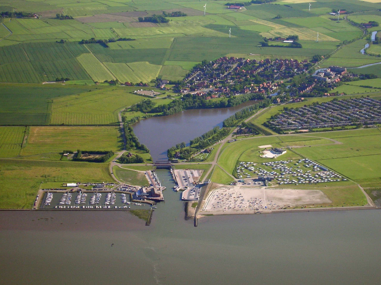
From the Air
Dornumersiel sits at 53.68 N, 7.47 E, directly on the Wadden Sea coast facing the island of Langeoog about 10 km to the north. The harbor entrance and sluice gate are visible from the air as a notched break in the otherwise straight dike line. The main parking lot for the Langeoog ferry passengers (the ferry itself departs from Bensersiel, 8 km east) appears as a large rectangle just inland. Nearest airfields: Wittmundhafen (ETNT) to the east, Norden-Norddeich (EDWS) to the west. Tide-driven mudflats extend several kilometers offshore at low water; the visual contrast between exposed Watt and inundated channels is one of the most striking sights on the North German coast.
Nearby Stories
- Juist 3.5 km away
- Varel 5.6 km away
- Wilhelmshaven LNG Terminal 6.8 km away
- HVDC DolWin2 7.2 km away
- Vossbarg 10 km away
- Heligoland Bight 10 km away
- Tiefwasserreede 13 km away
- Delfzijl 14 km away