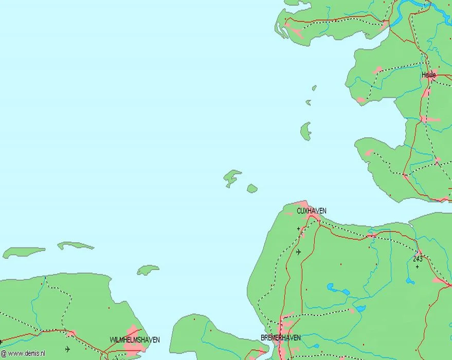
Heligoland Bight
Three times in the first half of the twentieth century, navies and air forces collided in this small patch of saltwater. The Heligoland Bight is barely the size of a Welsh county - sixty kilometers across, fifty-six meters deep at its deepest point - but the German fleet had to come out through it, and so anyone who wanted to fight the German fleet had to come in through it. Look at the chart and the geography explains itself: the Elbe flows out of Hamburg here, the red sandstone island of Heligoland sits at the bay's mouth like a cork, and between them runs one of the busiest shipping channels on Earth. Layer in fog, sandbanks, and the occasional submerged warship, and the bight starts to look less like a bay than a chokepoint.
The Mouth of the Elbe
Geographically, the Heligoland Bight forms the southern corner of the larger German Bight, which is itself the southeastern corner of the North Sea. The bight runs from the Elbe estuary northwest to the island it takes its name from, with the East Frisian island of Wangerooge marking its western edge and the Eiderstedt peninsula in Schleswig-Holstein closing it off to the east. Inside the bight lies the Heligoland Basin - Helgolaender Becken in German - a depression on the seabed that drops to fifty-six meters, deep by North Sea standards in waters that average less than thirty. Out of these waters rise the small island of Neuwerk near the Elbe mouth, the Wadden Sea mudflats that twice a day vanish under the tide, and Heligoland itself: forty square kilometers of red rock and the only piece of true cliff coast Germany owns.
The Funnel
If you ship goods from Hamburg to anywhere west of Denmark, you sail through the Heligoland Bight. The traffic from one of Europe's largest ports passes out through the Elbe, swings west across the bight, and threads down the North Sea toward the Straits of Dover and the English Channel. It is one of the most concentrated shipping routes in the world. Container ships, tankers, ro-ros, fishing boats, and the orange-hulled DGzRS rescue cruisers all share the same shallow water. Pilots board off Cuxhaven and Brunsbuettel. Traffic separation schemes keep northbound and southbound vessels in their lanes. The Vessel Traffic Service at Cuxhaven watches it all on radar. Beneath the keels, the chart is scattered with wrecks - merchantmen torpedoed in two wars, U-boats lost in diving accidents, cruisers sunk in 1914, Wellingtons gone down in 1939.
Three Battles
On 28 August 1914, a British force under Reginald Tyrwhitt and Roger Keyes raided the German destroyer patrols off Heligoland. Three German light cruisers - Mainz, Coeln, and Ariadne - went to the bottom along with the destroyer V187, and over seven hundred German sailors died. It was the first naval battle of the First World War, and the Kaiser was so shaken by the loss that he ordered the High Seas Fleet to avoid risk. A second, smaller surface action followed in November 1917. Then on 18 December 1939 came the third battle - this one fought in the air, when German fighters cut down half of an unescorted RAF Wellington formation over the same water. Three engagements, the same coordinates, three different generations of weapon: surface gun, dreadnought, and high-altitude bomber.
Wadden Sea and Wind Farms
Strip away the war history and the bight is something else entirely - one of the most carefully protected stretches of coastline in Europe. The Wadden Sea National Parks of Schleswig-Holstein, Hamburg, and Lower Saxony together form a UNESCO World Heritage site of intertidal mudflat, salt marsh, and shifting sandbanks where harbor seals haul out and millions of migrating birds refuel each spring and autumn. Guided mudflat hiking - Wattwandern - is a regional pastime. Out in the open water, offshore wind farms have multiplied since the early 2000s; the Alpha Ventus array, Germany's first, sits at the bight's northwestern edge. Beneath all of it, the seabed records every century: glacial gravels from the last ice age, medieval shipwrecks, modern pipelines, and the unexploded ordnance that the German Navy still quietly recovers each year.
From the Air
Located at 54.05 N, 8.15 E, in the southeastern North Sea. The bight extends roughly from the East Frisian island of Wangerooge in the southwest to Heligoland in the northwest and the Eiderstedt peninsula in the east, with the Elbe estuary at its southern apex. Cruising altitude of 6,000-10,000 feet on a clear day gives the full geometry: the red cliffs of Heligoland twenty-five nautical miles northwest of Cuxhaven, the chain of Frisian islands strung along the southern edge, and the Wadden Sea mudflats baring themselves at low tide. Nearest airports: Heligoland (EDXH) on Düne island, Wangerooge (EDWG) on the East Frisian chain, Cuxhaven/Nordholz (ETMN) on the mainland, and the major hubs at Bremen (EDDW) and Hamburg (EDDH) inland.
Nearby Stories
- Spiekeroog 3.1 km away
- Hohe Weg Lighthouse 9.8 km away
- SM UC-45 15 km away
- Amrumbank West 23 km away
- MV Pallas 25 km away
- Wöbbelin Concentration Camp 185 km away
- Lilleø 186 km away
- Ludwigslust Palace 195 km away