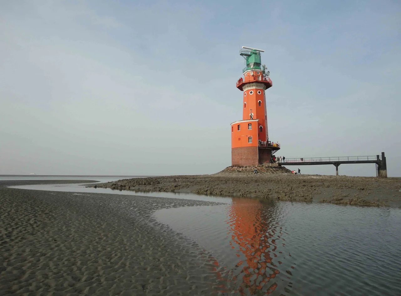
Hohe Weg Lighthouse
Twice a day the sea swallows the ground beneath the Hohe Weg lighthouse. At low tide a sandbank emerges and the lighthouse stands on dry land, ringed by ribs of wet sand and stranded crabs. At high tide the bank disappears and the tower is alone in open water, a red-and-white shaft rising straight out of the North Sea with no visible foundation. The men who built it had to wait for that same rhythm to do their work, hammering and pouring during the few hours each cycle when the bank let them. They started in 1854. The light first burned in 1856. It has been burning ever since.
A Bank With a Name
Hohe Weg is the name of both the lighthouse and the sandbank it stands on, a long shoal on the left bank of the outer Weser estuary, three kilometres south of the island of Mellum and twenty kilometres north of the mainland. The Weser was already one of the busiest river mouths in northern Europe by the eighteenth century - the trading city of Bremen lay upstream, and ships bound for it had to thread between sandbanks that shifted with every storm. Coastal maps from 1757 record a marker here, and in 1783 a wooden structure called the Bremer Bake was built to give ships a daytime reference point. As shipping volumes climbed in the early nineteenth century, the Bake was no longer enough.
Building in the Tide
Discussions about replacing the Bake with a proper fixed offshore light began in 1824 and ran for thirty years. Construction finally started in 1854. The challenge was simple to state and brutal to solve: the foundation had to sit on the sandbank, the sandbank was only exposed at low tide, and every working day was therefore bracketed by the rising water. Crews could hammer foundation pilings and lay stone for a few hours, then had to pack up, climb into boats, and watch the North Sea reclaim the construction site. The lighthouse rose by inches. It was completed in 1856 - the oldest fixed offshore lighthouse anywhere on the Weser estuary, and one of the earliest in the entire Wadden Sea.
Iron, Light, and Two Modernizations
The tower is cast-iron, painted in the bold red-and-white horizontal bands that mark it from kilometres away as a navigational aid rather than a residence. Between 1960 and 1961, it was modernized for the radar age: radar equipment, directional radio antennas, and a new optical casing were installed. In 1973 it was fully automated and the last lighthouse keeper packed his belongings and went ashore. The light has been unmanned since. Inside, much of the structure now functions as an emergency shelter for hikers caught by a rising tide while crossing the Wadden Sea - one of the last places in northern Europe where a misjudged walk can leave you stranded miles offshore, with the water climbing toward your knees.
A Stamp and a Sea
In 2006, on the lighthouse's 150th anniversary, the German postal service issued a special 55-cent stamp showing the tower at low tide, sand spreading around its base. It is a small honour, perhaps, but a fitting one for a structure that has done its job so quietly for so long. The Wadden Sea around it was declared a UNESCO World Heritage Site in 2009, recognized as one of the world's largest unbroken tidal flat ecosystems. Seals haul out on neighbouring banks, oystercatchers and avocets work the exposed mud at low water, and the lighthouse - half-submerged, half-dry, depending when you look - keeps shipping safely through the channel that the Weser cut here long before anyone thought to put a light on a sandbank twenty kilometres from shore.
From the Air
Coordinates: 53.70 N, 8.23 E, in the outer Weser estuary northwest of Bremerhaven. From altitude, the lighthouse appears as a tiny point on the western edge of the Weser shipping channel, with the island of Mellum to the north and the mainland of Lower Saxony to the south. Recommended viewing altitude 1,500 to 3,000 feet for the surrounding sandbank pattern at low tide. Nearest airports: Bremerhaven (EDWB) 25 km southeast, Bremen (EDDW) 80 km south, JadeWeserAirport (EDWI) west on the opposite side of the Jade Bight. Best visibility on a clear, low-tide morning when the sandbank is exposed.
Nearby Stories
- Wiesmoor 4.2 km away
- Battle of the Heligoland Bight (1939) 7.2 km away
- Stadland 7.6 km away
- Spiekeroog 8.2 km away
- Tiefwasserreede 21 km away
- Wöbbelin Concentration Camp 179 km away
- Ludwigslust Palace 183 km away
- Lilleø 203 km away