Stadland
Until the Wesertunnel opened in 2004, the next dry crossing of the Weser south of Stadland was at Bremen, more than forty kilometres upriver. For centuries this was a place where the only way across the river was by ferry, and the only way to make new land at all was to build dikes against the North Sea and pump out what was behind them. Seefeld, one of the four villages that make up modern Stadland, was founded in 1643 as a direct consequence of dike building and land reclamation. Three centuries later, in 1974, the territorial reform of Lower Saxony fused Seefeld with Rodenkirchen, Schwei, and Kleinensiel into a single municipality on the left bank of the Weser.
Where the Weser Meets the Sea
Stadland lies in the district of Wesermarsch, the marshland of the Weser, about 32 kilometres northeast of Oldenburg and 42 kilometres northwest of Bremen. On its west side the municipality borders the Jade Bight, the wide tidal bay that cuts inland toward Wilhelmshaven. The terrain is flat, green, and stitched with drainage ditches because nearly all of it sits at or just above sea level. The seat of local government is Rodenkirchen, the largest of the four villages with around 4,000 people, also the local training and sports centre. Each year at the end of September Rodenkirchen hosts the Roonkarker Mart, a funfair that draws visitors from across the Wesermarsch.
The Four Villages
Schwei, the second-largest village, has around 1,500 residents and an unusually long list of attached hamlets, the Bauernschaften: Norderschwei, Kötermoor, Süderschwei, Schweieraussendeich, Schweieraltendeich, Schweierfeld, and Schwei-West. Each name marks a small farming community out among the polders. Seefeld, founded in 1643 on freshly diked land, is still dominated by agriculture; its cultural landmark is the Seefelder Mühle, a historic windmill that hosts more than 50 events a year. Kleinensiel is the smallest, around 800 residents, and the one that ends up in the national news most often, because the Unterweser nuclear power station stands right outside the village. The plant was shut down in 2011 in the wake of Fukushima and is now being decommissioned.
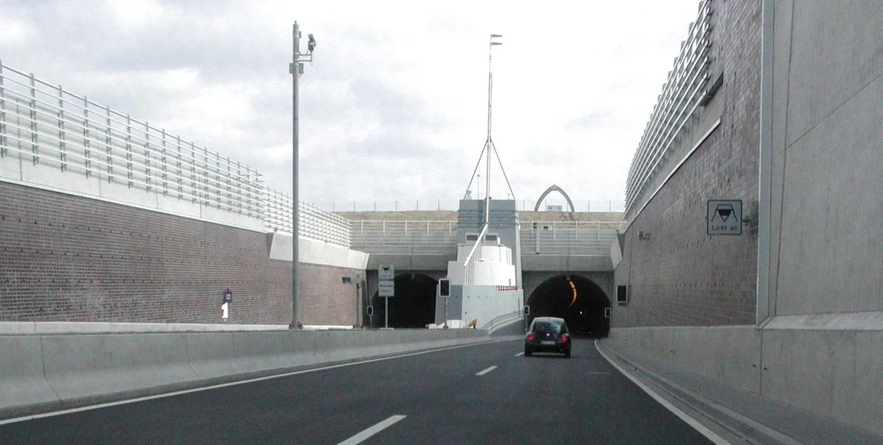
A Tunnel Under the River
Before 2004 there was no road crossing of the Weser between Bremen and the North Sea. Cars travelling between the Wesermarsch and the eastern bank had to take a ferry, often with hour-long waits in summer, or drive south all the way to Bremen. The Wesertunnel, opened that year, runs underneath the river at Kleinensiel and connects the B212 federal road on the west bank with the A27 motorway on the east. It is one of only a handful of road tunnels under a major German river. For Stadland the tunnel changed daily life: a trip to Bremerhaven, which used to require a ferry ticket and patience, now takes about twenty minutes.
A Painter, a Philologist, and Two Writers
For a municipality of barely 7,000 people, Stadland's list of native sons and daughters is surprisingly literary. Alma Rogge and Amanda Jürgens were both German writers; Rogge in particular became known for her Plattdeutsch theatre. The painter Franz Radziwill was born in Strohausen, a hamlet within what is now Stadland, in 1895 and spent most of his life in nearby Dangast painting Magic Realist landscapes of the North Sea coast. The German-Austrian philologist Jakob Schipper also came from here, a specialist in Middle English and metre who taught at the University of Vienna. The Stadland landscape, the long horizons, the high skies, the flat green polders, has always seemed to push people toward looking either at it or away from it.
Dikes, Ferries, and the Friesendenkmal
Stadland's identity is shaped by water management. The whole municipality sits behind dikes built and maintained over four centuries. The Friesendenkmal, the Frisian monument in Rodenkirchen, commemorates the Frisian peasants who fought historically for political independence and free dike management. The municipality has a partnership with the District du Petit Caux in Normandy, formalised by mutual visits each year between local administrators and private citizens. There is no train station; the nearest rail link is at Nordenham, on the southern edge of the municipality, where one of the four villages, Kleinensiel, was carved out in 1974 from what had been the old municipality of Esenshamm. Most visitors arrive by car through the new tunnel, or down the B437 from the north.
From the Air
Stadland sits at 53.4247 degrees N, 8.3742 degrees E, on the left bank of the Weser in the Wesermarsch district. From altitude the polder landscape is unmistakable: a checkerboard of green fields divided by perfectly straight drainage ditches, edged by the prominent grey-green ribbon of the Weser to the east and the Jade Bight to the west. The Unterweser nuclear plant's distinctive containment structure is the most prominent vertical landmark at Kleinensiel. The Wesertunnel approach roads converge near the river. Bremen Airport (EDDW) is about 65 kilometres south; Wilhelmshaven-Mariensiel (EDWI) about 35 kilometres west. The B437 federal road threads through the municipality.
Nearby Stories
- Vossbarg 5.2 km away
- Saterland Frisian language 6 km away
- Hatten 9.6 km away
- Hohe Weg Lighthouse 10 km away
- Spiekeroog 18 km away
- Ludwigslust Palace 179 km away
- Gardelegen Massacre 187 km away
- Lilleø 227 km away