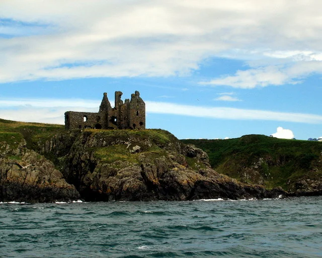

Dunskey Castle
From the clifftop south of Portpatrick, Dunskey Castle looks like something a child might draw to mean ruin - a roofless shell of grey stone perched on a promontory above the sea, with the open Irish Sea behind it and, on a clear day, the dark line of Northern Ireland visible across the water. The film crews who came in 1951 to shoot Robert Louis Stevenson's Kidnapped knew exactly what they were after; they came back the following year for Hunted, and again in 1992 for Double X. Dunskey is, as one Wikipedia editor put it without apology, undoubtedly romantic. But strip away the cinema and the silhouette and the castle's real story is something darker and more particular: a 12th-century tower house that watched four hundred years of Galloway's feuding lairds, that was burnt at least once by a neighbour, and that fell into ruin only fifty years after one of its grandest expansions.
Stone on a Promontory
The structure itself is an L-plan tower, three storeys high in its original form, defended on its only landward approach by a rock-cut ditch fifteen metres wide and two and a half metres deep. The walls are a metre and a half thick. A separate watchtower, seven metres square, once stood at the cliff edge - the cartographer Timothy Pont, mapping Galloway around 1580, showed two such watchtowers fronting the sea. By the time Francis Grose came to sketch the ruins in 1790, much had already collapsed. His drawing shows what looks like the main entrance in the southern corner, with a staircase leading up to a hall added around 1520. The site is a scheduled monument now, given national protection, though public access is restricted by the current owner. Even from a distance, the silhouette is unmistakable: stone walls open to the sky, the sea breaking white at the foot of the cliff, and behind it all the same view the castle's first builders chose - command of the coast, command of the approach, and nowhere for an enemy to hide.
The Adairs and Their Enemies
For most of its inhabited life, Dunskey belonged to the Adairs of Kinhilt, a Galloway family with deep roots in Wigtownshire. Their tenure was not peaceful. In 1488, William Adair of Dunskey and Archibald McCulloch of nearby Ardwell were attacked by Sheriff Quentin Agnew of Lochnaw Castle and his men - a raid that ended up before the Lords of Council, with Agnew ordered to pay for goods taken. Just a year later, around 1489, the tables turned. Sir Alexander 'Sandy' McCulloch of Myrtoun came down on Dunskey and partially burned it. A pardon was granted in 1499 for the burning, naming his accomplices. In 1496, McCulloch and a McDowell ally attacked again, this time over an accusation of murder; they assigned the castle, raised fire and burned the same, leaving William Adair with damages amounting to forty pounds Scots - real money - plus stolen horses, cattle, and salted hides. The records of these raids survive in the Lords of Council's complaints, written in the dense, abbreviated Scots of the late fifteenth century. The Adairs rebuilt, married into the McDowells to end the feud, and carried on. Ninian Adair, who took the estate in 1513 after his father died at the Battle of Flodden, was said to have rebuilt Dunskey on a more magnificent scale than ever.
From Gallery Wing to Roofless Shell
In February 1620, the castle passed to Hugh Montgomery, 1st Viscount Montgomery of the Ards in County Down. Montgomery had Irish estates just across the water - on a clear day, you could see one from the other - and he added a 'Gallery' wing to Dunskey with vaulted cellars beneath. It was the castle's last significant expansion. Within a generation, Montgomery's debts caught up with him; he had bankrupted himself sustaining troops during the upheavals of the 1640s, and Dunskey passed to the Blair family, who were ministers at Portpatrick. By 1684, only fifty years after that handsome new gallery was finished, the Laird of Dunskey had moved out to nearby Killantringan, and the castle stood in ruin. Local tradition added a cave that 'goes a considerable distance under ground' and a ghostly piper said to pace back and forth somewhere in its depths - the kind of story that gathers around any sea-cliff ruin given time enough.
The Edge of Two Countries
Stand at Dunskey on a clear evening and the geography that made it matter is suddenly obvious. Twenty-one miles west across the North Channel, Northern Ireland is a low blue line - the area around Larne and Islandmagee that Francis Grose marked in his 1790 drawing of these same ruins. Portpatrick, half a mile north, was the historic short-crossing point to Ireland for centuries; before steam, before the railway swung the traffic to Stranraer, this was where the post and the cattle and the soldiers came across. The Adairs and the McCullochs and the Montgomerys built and burned and rebuilt here because the coast itself was a chokepoint - the closest Scotland comes to Ireland, and therefore the place where holding a castle could mean holding the route.
From the Air
Dunskey Castle stands at 54.835 deg N, 5.110 deg W, half a mile south of Portpatrick on the south-west coast of Scotland. From the air, the castle reads as a small grey rectangle on the lip of a sea-cliff promontory, with the open Irish Sea to the west and Northern Ireland visible 21 nm beyond. Glasgow Prestwick (EGPK) is the nearest major airport, roughly 55 nm north-east; West Freugh (EGOY) lies about 9 nm east near Stranraer. Visual landmarks: Portpatrick's harbour just north, the white tower of Killantringan Lighthouse a couple of miles further north, and the broad south-west sweep of the Rhins of Galloway peninsula curving south toward the Mull.
Nearby Stories
- Glasserton 6 km away
- Battle of Glen Trool 9.5 km away
- Ballantrae Lifeboat Station 11 km away
- International Institute of Space Commerce 11 km away
- Bangor Abbey 12 km away
- Downpatrick and County Down Railway 20 km away
- Portavogie 23 km away
- Cushendall 29 km away