Fort des Dunes
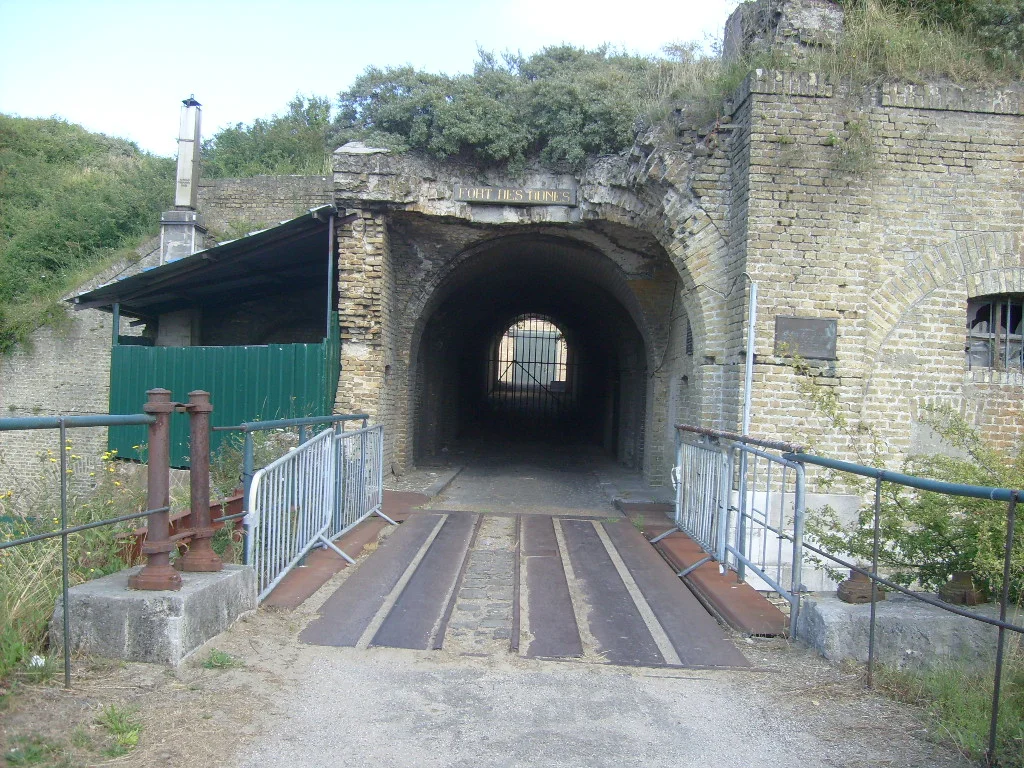
The fort is mostly invisible. It sits on a 27-metre sandy hill in the dunes at Leffrinckoucke, six kilometres east of Dunkirk, and the only signs from a distance are the slope of the ground, the line of the dry moat, and a low rectangle of brick and stone that looks like part of the landscape. The barracks are recessed into the surface and covered with soil and turf. As much as six metres of sand cover the magazines. This is how the French Army of the Third Republic preferred its fortifications after 1870: dug in, buried, designed to disappear from the artillery's line of sight. It worked for the war it was built for - which never came - and it worked imperfectly for the war that did.
The War That Never Arrived
France lost the Franco-Prussian War in 1871 and lost Alsace-Lorraine with it. The country's response, beginning in the late 1870s, was a system of frontier forts designed by General Raymond Adolphe Séré de Rivières. The Séré de Rivières system stretched from the Belgian border down to the Mediterranean, hundreds of forts and outworks built to absorb a German offensive and gain time for the French Army to mobilise. The Fort des Dunes was built between 1878 and 1880 as the westernmost of these frontier forts. It guarded the coastal railway and canal east of Dunkirk, was armed with about twenty-five artillery pieces and a garrison of 451 men, and was protected by a dry moat with caponiers - covered firing positions that could sweep the length of the ditch with rifle fire. Across the next four decades, artillery technology raced past the design. The fort's exposed gun positions, once state-of-the-art, became indefensibly obsolete. When the First World War arrived, the Fort des Dunes was well behind the lines. It served as a munitions depot, garrisoned mostly by reservists, and did not fire a shot in anger.
1940: The War It Did Fight
In late May 1940, with the British Expeditionary Force pulling back to the beaches and the French rearguard fighting to keep the Dunkirk perimeter alive, the Fort des Dunes became a strongpoint on the eastern flank of the line. The French 12th Motorised Infantry Division - including the men of the 150th Infantry Regiment - based itself in and around the fort. They held the position under heavy German air and artillery bombardment for several days. The fort's commander, General Janssen, was killed in the fighting; his widow would attend the re-interment ceremony of those killed there fifteen years later. The fort was taken by German forces after the last evacuations from the Dunkirk beaches and port had ended on 4 June. The men of the 12th Motorised, who had held the line until evacuation was no longer possible, were taken prisoner. Most of them spent the rest of the war in German camps, and most of the rest of their lives never spoke about what those days had been. The scars on the fort's entry tunnel - still exposed today - date from this bombardment.
German Occupation
The Germans repaired the fort and made it a small node in the much larger Atlantic Wall, the chain of coastal fortifications running from Norway to the Spanish border. The Fort des Dunes itself became an annex to the larger Zuydcoote battery up the coast: a rations depot, a flak position, a radar installation. Local citizens and prisoners of war were made to reinter the French soldiers who had been buried where they fell or entombed by debris during the May fighting. The German garrison settled in for a long stay. They painted murals and decorations in the magazines and barracks - some of which are still legible on the walls. When German forces in the Dunkirk Pocket finally surrendered on 9 May 1945, 10,000 men were taken prisoner; 3,700 of them stayed in the Dunkirk area, many at the Fort des Dunes, and were put to work clearing rubble and removing mines from the same beaches their predecessors had defended.
Customs and Silence
The fort's post-war career was anti-climactic. The French customs service took it over and used it as a storage centre for seized goods. A customs officer and his family moved in and lived there for a stretch of years. In 1955 the army returned to begin proper excavations to recover the remains of those killed in the May 1940 fighting. The ceremony of re-interment that August - attended by General Janssen's widow - was the first formal recognition the dead of Fort des Dunes had received from their own country. Then the fort was abandoned again. For twenty years it sat empty in the dunes, its tunnels filling with sand, the murals fading, the scars on the entry passage weathering. In 1978 a local association formed to preserve the structure. By 1990 it had been made habitable. In 1998 it was transferred to the commune of Leffrinckoucke.
A Quiet Memorial
The Association Fort des Dunes now maintains and interprets the site. It is usually open to the public on summer weekends. Visitors walk across the drawbridge over the dry moat, past the caponiers that were designed to sweep an attack with rifle fire, into magazines whose roofs still hold their six metres of sand. The German murals remain on some walls. The scars of 1940 remain on others. The fort that was built to absorb a German invasion that came along the inland frontier ended up absorbing a different German invasion that came along the coast - and absorbing it with men who never got out. The remembrance is not loud. The Dunkirk Memorial commemorates the British missing of 1940 in Portland stone, a few kilometres west; the Fort des Dunes commemorates a small fraction of the French dead in the structure where they died. Both feel necessary.
From the Air
The Fort des Dunes sits at 51.053°N, 2.447°E in the commune of Leffrinckoucke, about 6 km east of central Dunkirk and within a few hundred metres of the English Channel. From the air it reads as a low rectangular plateau in the dunes - more shape than structure, with a slight rise of about 27 m above the surrounding sand. The coastal railway running east toward Belgium passes just south of the site. Nearest airfields: Calais-Dunkerque (LFAC) 35 km west; Ostend-Bruges (EBOS) 45 km northeast. Recommended viewing altitude 1,500-3,000 ft over the coast; the fort is most visible when low light from the south brings out the geometry of the moat and ramparts.
Nearby Stories
- Mines in the Battle of Messines (1917) 4 km away
- Yser Towers 4.6 km away
- Abbey of Saint Bertin 5.8 km away
- MV Tricolor 7.2 km away
- Battle of Dover Strait (1916) 11 km away
- St James's Day Battle 12 km away
- Chateau de Boulogne-sur-Mer 13 km away
- Zeebrugge Raid 27 km away