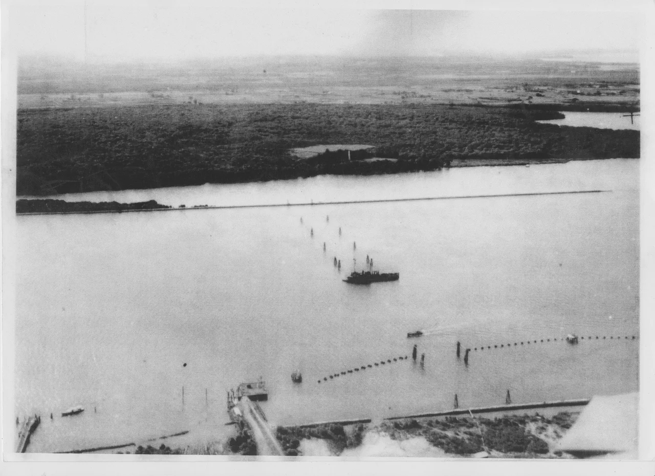

Fort Lytton
From the river you would barely know it was there. At the mouth of the Brisbane River, where the water finally spills into Moreton Bay, low grassy ramparts rise out of flat ground and conceal a five-sided fortress ringed by a water-filled moat. Fort Lytton was built between 1880 and 1882 to defend a nervous colonial capital against an enemy fleet, and for more than eighty years its guns watched the river. They were almost never fired in anger. The fort's true history is not one of battle, but of a young city bracing for a storm that never quite broke.
A Colony Looking Over Its Shoulder
In 1880, Brisbane had fewer than 100,000 people but an annual trade worth over four million pounds, and it felt exposed. Australia belonged to the British Empire, but rival powers were carving up the Pacific, and Brisbane lay just three days' sail from the French naval garrison at Noumea. Moreton Bay was scattered with islands where a hostile fleet could shelter. On the advice of two eminent British military engineers, Sir William Jervois and Lieutenant-Colonel Peter Scratchley, the Queensland Parliament approved a fort at Lytton in 1878, and Scratchley designed it: a pentagonal earthwork garrison hidden behind embankments and protected by its moat. The fear was specific and named. Russia and France were the bogeymen, and the whole structure was an answer to the question that haunted every far-flung colonial port: what if they came for us?
Guns That Vanished
Fort Lytton's defence began as a remote-controlled minefield strung across the river mouth, backed by four heavy muzzle-loading guns. The real ingenuity came later. By 1888 the fort had two six-inch breech-loading "disappearing guns," mounted on hydro-pneumatic carriages that hauled the barrel up to fire over the rampart, then dropped it back below the parapet about twenty seconds later, out of an enemy's sight and line of fire. Quick-firing Hotchkiss guns were added soon after. The minefield was closed in 1908, but the disappearing guns kept watch until 1938. A passing ship would have seen only an innocent green bank, with no hint of the heavy ordnance that could rise from behind it, fire, and sink from view before the smoke had cleared.
The Citizen Soldiers
For most of its life, the fort's real work was training. For its first forty years it was the main base for Queensland's reserve soldiers, ordinary men who turned out each year for the famous "Easter Encampment," up to 5,000 of them pitching tents on the flats around the fort. Thousands trained here before shipping out to the Boer War, the First World War and the Second. These were not professional warriors but clerks, labourers and farmers learning the trade of arms for a fortnight at a time, then going home. The grainy old photographs of soldiers and horses massed at Lytton are a portrait of a colony, and later a young nation, building its army out of volunteers, one Easter at a time.
The Fort's Last Watch
Fort Lytton's most dramatic role came in the Second World War, when Brisbane became a major Allied submarine base and 89 submarines were dry-docked there over three years. The fort anchored the river's defences: an anti-submarine boom net stretched across the channel, opened and closed by winches at the fort and on a permanently moored ship, the HMAS Kinchela, with heavy guns trained on the gap. After the war the guns fell silent, but the signals station kept listening, even gathering intelligence on the 1965 upheaval in Indonesia before it finally closed that year. The site was handed to an oil company, which transferred the historic fort back to the state in 1988. In 1990 it became Fort Lytton National Park, its ramparts now grassed and quiet, a fortress that fulfilled its purpose precisely by never having to prove it could.
From the Air
Fort Lytton sits at approximately 27.412 degrees S, 153.151 degrees E at the mouth of the Brisbane River in the suburb of Lytton, where the river opens into Moreton Bay. From the air the fort is camouflaged by its low grassy ramparts and is best located by the surrounding landmarks: the mouth of the Brisbane River, the sprawling Lytton oil refinery immediately around the national park, the Port of Brisbane container terminals just to the east, and the broad expanse of Moreton Bay and its islands beyond. Brisbane Airport (ICAO YBBN) lies just 6 km to the northwest, so expect controlled airspace and arriving and departing traffic; Archerfield Airport (ICAO YBAF) is about 17 km southwest. Best viewed from 1,000 to 2,500 feet, conditions and airspace permitting; sea breezes and coastal haze off the bay can affect visibility.
Nearby Stories
- Bribie Island 12 km away
- Cressbrook Homestead 17 km away
- Beenleigh Rum Distillery 18 km away
- Main Range National Park 39 km away
- 2010-2011 Queensland Floods 47 km away
- Cape Byron 115 km away
- Cape Byron Light 145 km away
- HMS Porpoise (1799) 570 km away