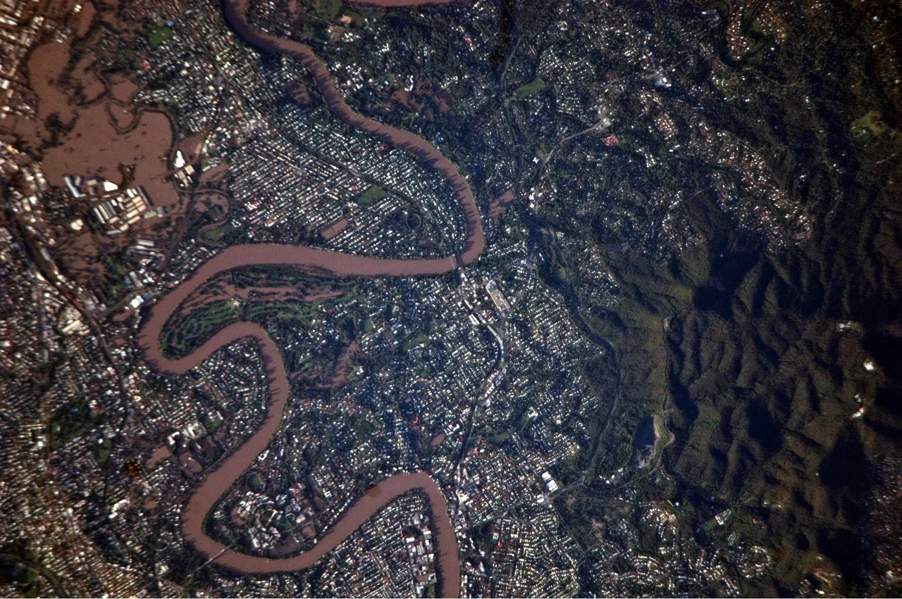

2010-2011 Queensland Floods
On the afternoon of 10 January 2011, the storm that had been sitting over Toowoomba for hours stopped behaving like rain and started behaving like a sea. More than 160 millimetres fell in 36 hours, and the gully creeks that run beneath the city's streets could not hold it. Water rose through the central business district in minutes, lifting cars and carrying people away. Four died there in a matter of hours. Survivors would call what they witnessed an inland tsunami, and the worst of it had not yet reached the valley below.
A Drowning Summer
The disaster did not arrive all at once. It built through the wettest spring and the wettest December that Queensland had ever recorded, the legacy of a powerful La Nina that turned the tropics into a tap that would not close. By late December 2010, rivers across the state were swelling. Rockhampton, Theodore, Dalby, Bundaberg, Emerald: town after town went under. At its height the flooding touched more than 90 towns and over 200,000 people, and roughly three-quarters of Queensland was declared a disaster zone. An area larger than France and Germany combined lay underwater. For weeks the story was one of slow inundation, of sandbags and stranded livestock. Then, in January, the catastrophe found a faster and more terrible gear.
The Lockyer Valley
The same storm cell that struck Toowoomba poured off the range and into the Lockyer Valley, a patchwork of farming communities on the rich black soil below the escarpment. There the water concentrated into a wall. It came through Murphys Creek and Withcott and then Grantham, a small town that took the full force of it. Houses were torn from their foundations. Families were separated in the dark and the noise. Nine people were confirmed dead at Grantham, and for days dozens more were listed as missing; one victim swept from the town was eventually found 80 kilometres downstream. These were not statistics. They were grandparents and tradesmen and children, neighbours who had woken that morning to ordinary lives. Of the 33 people who died across the whole disaster, 21 were first caught by the floodwater on that single day, 10 January, in Toowoomba and the valley below.
Brisbane Goes Under
Downstream, a city of two million braced. The Brisbane River, fed by saturated catchments and by water released from a Wivenhoe Dam that had filled past 190 percent of its supply capacity, climbed toward the suburbs. On 13 January the river peaked, and around 20,000 homes across Brisbane and Ipswich flooded. The financial district emptied as workers fled. Whole streets in riverside suburbs vanished beneath brown water, with only rooftops and the crowns of drowned trees breaking the surface. The cost ran into the billions and shaved a measurable slice off the state's economy, but the figure that mattered most was the human one, and that ledger was still open as the search teams worked the Lockyer Valley mud.
We Are Queenslanders
At the height of the crisis, Premier Anna Bligh stood before the cameras, her voice cracking, and said: "We are Queenslanders. We're the people that they breed tough, north of the border. We're the ones that they knock down and we get up again." It became the refrain of the recovery. In the weeks that followed, tens of thousands of volunteers, the so-called Mud Army, shovelled out homes that were not their own. Grantham eventually rebuilt on higher ground. Toowoomba marked the places where the water had risen. A coronial inquiry examined every death and the operation of the dam. The grief did not lift quickly, and for the families who lost someone on 10 January it never fully will. What the floods left behind was a state that had measured itself against the worst its rivers could do, and a memory of the day the water came down off the range.
From the Air
The flood disaster centred on southeast Queensland, with the deadliest flash flooding around Toowoomba (27.56 degrees south, 151.95 degrees east) atop the Great Dividing Range and in the Lockyer Valley immediately to the east, where Grantham sits near 27.57 degrees south, 152.21 degrees east. The Brisbane River flooding extended downstream to Brisbane itself at 27.47 degrees south, 153.03 degrees east. From the air, the geography tells the story: Toowoomba perches on the escarpment edge, and the land drops sharply eastward into the Lockyer Valley's creek systems before flattening toward the coast. Toowoomba Wellcamp Airport (YBWW) lies just west of the city; Brisbane Airport (YBBN) is roughly 70 nautical miles northeast on the coastal plain. Wivenhoe Dam, central to the Brisbane flood, sits on the upper Brisbane River northwest of the city. In wet summers under a strong La Nina, towering storm cells can stall against the range here, the same setup that produced the 2011 catastrophe.
Nearby Stories
- North Ipswich Railway Workshops 20 km away
- Main Range National Park 22 km away
- Cressbrook Homestead 41 km away
- Woodford Folk Festival 41 km away
- Jimbour Homestead 43 km away
- Tamborine National Park 60 km away
- Warialda 217 km away
- Inverell 254 km away