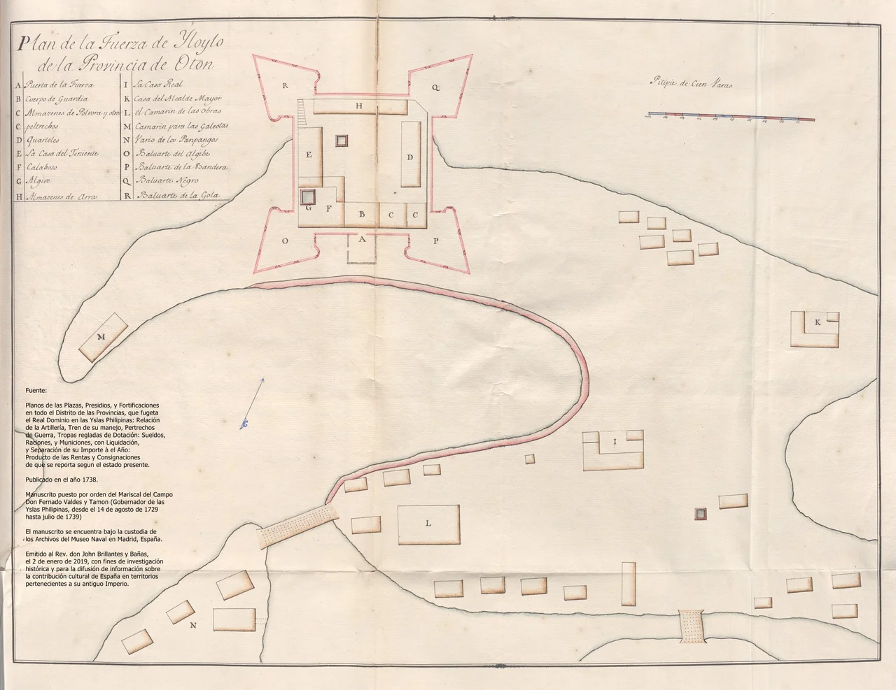
Fort San Pedro (Iloilo)
A Spanish captain named Joan Garcia de Sierra died defending a wooden fort at Arevalo against raiders from Mindanao in 1599. Three years later, colonial governor Pedro Bravo de Acuna ordered the construction of a new fortification at the port of Iloilo, a structure that would bear the name Fort San Pedro and carry the formal title Fuerza de la Nuestra Senora del Rosario, the Fortress of Our Lady of the Rosary. It was the second Spanish-built fort in the Philippines and in all of Asia, following only its namesake in Cebu. By 1945, it was rubble.
Wood, Then Stone
The original Fort San Pedro was built of wood in 1602, a practical response to the twin threats of Moro raiders from the south and Dutch naval forces probing Spanish defenses across Southeast Asia. The wooden structure served its purpose until 1616, when the Dutch attacked Iloilo. Diego de Quinones led the defense and subsequently oversaw the fort's transformation from timber to stone, creating a more permanent fortification capable of withstanding naval bombardment. During the reconstruction, workers discovered an image of Our Lady of the Most Holy Rosary among the ruins. The image was preserved and eventually enshrined at San Jose Church, where it remains today. The fort's full original name, Fortificacion de Nuestra Senora del Rosario en el Puerto de Yloylo, Provincia de Oton, reflects both its martial purpose and its religious dedication.
From Presidents to Bombs
Fort San Pedro's military significance outlasted the Spanish colonial period. On October 10, 1903, U.S. President Theodore Roosevelt declared the fort and its surrounding area a military reservation. In 1936, Philippine President Manuel L. Quezon designated it a Philippine Army post. When the Japanese Imperial Army invaded Iloilo during World War II, they seized the fort and converted it into their headquarters, a decision that would seal its fate. In March 1945, combined American naval and air forces launched a systematic bombardment of all Japanese installations in Iloilo. Fort San Pedro, a structure that had evolved across three centuries from wooden palisade to stone fortification to army post, was pulverized in the attack. The bombing left only fragments of the walls and foundations, erasing most of the physical structure while paradoxically confirming its strategic importance. Three colonial powers and one republic had each recognized the same piece of ground as worth controlling.
Ruins and Recognition
Since 2015, proposals to reconstruct Fort San Pedro have circulated through various levels of government. In 2016, the National Museum of the Philippines declared the site an important cultural property and designated it as a component of a broader cultural heritage tourism zone in Iloilo City. The declaration recognized not just the ruins but the layers of history embedded in the site, from the pre-colonial wooden defenses at Arevalo through the Spanish stone fortification to the American military reservation and the Japanese occupation. In October 2024, the National Museum signed a formal agreement to restore and develop the site, with construction scheduled to begin in 2025. The planned restoration will attempt to reconstruct the fort based on historical plans and archaeological evidence, bringing back into physical form a structure that has existed only as fragments and documents for eight decades.
Contested Ground, Still
Even as restoration plans advance, Fort San Pedro remains the subject of competing visions. A proposal to transfer roll-on, roll-off ferry operations from the ports at Dumangas and Lapuz to the Fort San Pedro site has sparked debate about how to balance heritage preservation with the city's need for modern transportation infrastructure. The waterfront location that made the site strategically valuable to Spanish colonial governors and Japanese military commanders makes it equally attractive to port authorities looking for berthing space for ro-ro vessels. The tension is not new. Fort San Pedro has been repurposed by every power that has controlled it, each one layering its own needs over the remains of its predecessor. Whether the next layer will be a reconstructed historical monument or a ferry terminal, or some combination of both, remains an open question. The ground, as it has for four centuries, awaits its next chapter.
From the Air
Coordinates: 10.688N, 122.580E, on the waterfront of Iloilo City Proper on the southeastern coast of Panay Island. The fort site is located near the port area at the mouth of the Iloilo River. Nearest major airport: RPVI (Iloilo International Airport) approximately 19 km north. From altitude, the site is part of the dense urban waterfront of downtown Iloilo, near the Iloilo Strait separating Panay from Guimaras Island. The ruins and surrounding area are at sea level.
Nearby Stories
- Hacienda Rosalia 11 km away
- San Jose de Buenavista 13 km away
- Guimaras Oil Spill 17 km away
- Northern Negros Natural Park 19 km away
- Jalaur Dam 31 km away
- 2012 Negros Earthquake 50 km away
- Maniguin Island Lighthouse 84 km away
- Tubbataha Reef 281 km away