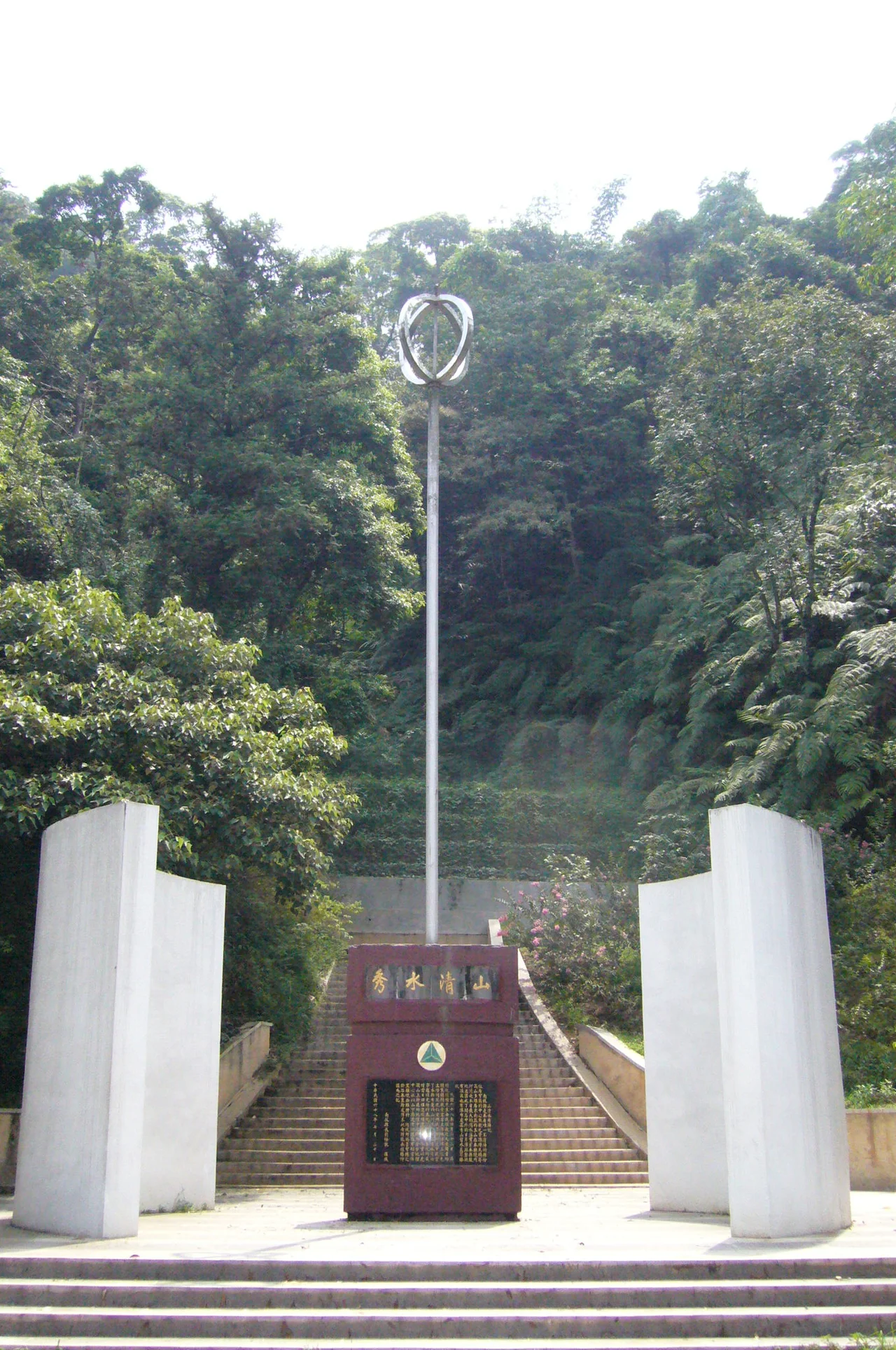

Geographic Center of Taiwan
Somewhere in the green folds of Nantou County, Taiwan folds inward on itself. The mountains tighten, the valleys narrow, and the island discovers its own center — a point called Hutoushan, Tiger Head Mountain, rising above the small town of Puli. There is something quietly extraordinary about a place where every direction is equally Taiwan. The monument that marks it is not grand, but the idea it embodies is.
Three Monuments, Three Histories
Finding the center of Taiwan turned out to be harder than it sounds. The first monument was built in the 1970s at the base of Mount Hutou, placed with the surveying technology of the day and declared good enough. Then came better instruments, more precise calculations, and the realization that the true center lay higher up — on the peak itself. A second monument was built on the summit, correcting the first. What visitors find today, then, is a record of improving knowledge: two markers separated by the vertical distance between confidence and certainty.
The peak monument holds a quieter history inside its stones. Before it was built, the summit held the Yoshitaka Shrine, erected during Japan's decades of colonial administration over Taiwan. When that era ended in 1945, the shrine came down. In its place, Taiwan placed its own center point — a deliberate act of geographic and cultural reclamation.
Four Hundred Steps to the Middle of the Island
Getting to the center of Taiwan requires some effort. Four hundred stairs climb from the base of Mount Hutou to the peak monument, through the subtropical greenery that drapes Nantou's hills. The ascent is steady rather than brutal, but it reminds you that the heart of this island is not the coastline — it is the interior highlands, the forested ridges and river valleys that most visitors bypass in favor of the beaches and cities at the edges.
At the base, a stone monument carries an inscription by former President Chiang Ching-kuo, four classical Chinese characters: *Shan Qing Shui Xiu* — mountains clear, waters beautiful. It is an apt description of the surrounding landscape, where the Central Mountain Range catches clouds and feeds the rivers that make Puli famous for its water. On top of the monument pole, concentric steel rings form an abstract design that doubles as the logo of Puli Township — the center of an island, rendered in a circle.
Aboriginal Columns in an Ancient Valley
The peak monument was built in an indigenous style, its columns topped with flared caps drawn from the visual vocabulary of Taiwan's aboriginal communities — the peoples who inhabited these highlands long before any survey was ever taken. The acknowledgment is subtle, architectural rather than explicit, but it gestures toward a deeper history than any monument can fully capture.
The valley below belongs to the Atayal and other indigenous groups whose territories spread through the mountains of central Taiwan. Puli Township's name comes from a Chinese rendering of an indigenous place name. The town grew at the intersection of plains and highlands, a meeting point that long preceded the Republic of China, the Japanese period, or the Qing dynasty before that. The geographic center of Taiwan has been, in a sense, a human center for far longer than any government has kept records.
Sun Moon Lake and the Surrounding World
Tiger Head Mountain does not stand alone. Southeast of Puli, just a few kilometers through the folded terrain, lies Sun Moon Lake — Taiwan's most celebrated inland body of water, one of the country's most visited destinations. The geographic center of Taiwan, in other words, sits at the edge of one of its most iconic landscapes.
From the summit, on clear days, the view opens across the Puli Basin and into the surrounding ranges. The Central Mountain Range to the east forms a wall of peaks that keeps the Pacific Ocean on the far side. To the west, the terrain softens toward Taichung and the coastal plains. The monument itself is accessible by bus from Taichung Station — a practical connection that reminds visitors that this is not wilderness, but a working, inhabited heart of an island of 23 million people.
From the Air
Tiger Head Mountain (Hutoushan) sits at approximately 23.976°N, 120.974°E, rising above the Puli Basin in central Nantou County. From the air, the Puli valley is visible as a flat, cultivated bowl surrounded by forested ridges — a conspicuous clearing in an otherwise densely mountainous landscape. The nearest major airport is RCMQ (Taichung International Airport / Ching Chuan Kang Air Base), approximately 45 km to the northwest. At low altitude, the monument area is not readily visible, but the distinctive shape of the Puli Basin — roughly oval, drained by the Wu River's tributaries — makes the region easy to identify. Approach from the west offers the clearest view of the valley floor and the ridgeline where the peak monument stands.
Nearby Stories
- Niumatou Site 1.3 km away
- 27 Brigade 3.9 km away
- Gukeng 9.2 km away
- 1951 East Rift Valley Earthquakes 12 km away
- Shei-Pa National Park 15 km away
- Nanao (Taiwan) 28 km away
- Lintianshan Forestry Culture Park 29 km away
- Mavulis Island 292 km away