
Glarentza
The town had many names. Clarence in French, Chiarenza in Italian, Clarentia in Latin, Glarentza in Greek — each version a reflection of which trading network was doing the naming. For the merchants of Venice and Genoa who sailed into its harbor in the 13th and 14th centuries, Glarentza was a known quantity: the principal port of the Frankish Morea, the place where goods entered and silver coins left. The coins it minted — the silver tornese, stamped at the Principality of Achaea's official mint — circulated across the medieval Mediterranean. The harbor that sheltered them has silted into a swamp.
Founded on the Best Anchorage in Elis
Glarentza was established in the mid-13th century by William II of Villehardouin, who ruled the Principality of Achaea from 1246 to 1278. The Principality was a Frankish state created after the Fourth Crusade's diversion to Constantinople, and it encompassed most of the Peloponnese. William chose the site deliberately: the headland at the extreme northwestern tip of the peninsula, known in antiquity as Chelonatas, had been recognized since ancient times as the best anchorage in all of Elis. It was very likely the site of the ancient port city of Cyllene.
The new town occupied an irregular plateau roughly 450 meters east-to-west and 350 meters north-to-south — about 8,800 square meters of urban ground. Its northern and western sides dropped in cliffs roughly 50 meters to the sea, providing natural defense. The port occupied an excavated basin in the north, probably separated from open water by an artificial mole, with the entrance from the west to shelter vessels from the dangerous westerly and southwestern winds. A city wall of modest construction — perhaps 1.8 meters thick, reinforced by rectangular towers — enclosed the settlement, with a small citadel in the southwestern corner.
The Administrative Heart of the Morea
Glarentza was never an isolated port. Three sites together formed the administrative core of the Principality of Achaea: the capital Andravida, 13 km inland to the east; Chlemoutsi, the great hilltop castle 5 km to the south; and Glarentza itself, the maritime gateway. Trade with Italy — above all with Venice and Genoa — brought the town prosperity sufficient to sustain its mint. The Principality's silver tornese coins, struck at Glarentza, were accepted across the eastern Mediterranean.
The church that A. Bon identified as the Franciscan church — a large structure measuring about 43 meters in length, of unusual size for its relatively simple construction — stood in the town's northeast. Assemblies of the Achaean nobility were held here in 1276 and 1289. The town's population included Franks, Greeks, and Italian merchants; it was the kind of cosmopolitan settlement that medieval ports in the Latin East routinely produced. When Ferdinand of Majorca landed at Glarentza in June 1315 to claim the Principality, the town's strategic importance was the immediate reason he chose it as his beachhead.
A Byzantine Co-Capital
The Principality of Achaea declined across the 14th century as the Angevin grip weakened and Byzantine power in the Morea gradually recovered ground. Glarentza changed hands with the Principality. In 1418 it passed to Carlo I Tocco, and a decade later, in 1427, after a naval defeat at the Battle of the Echinades, Tocco ceded both Glarentza and Chlemoutsi to Constantine Palaiologos, Despot of the Morea — who would later become the last Byzantine emperor.
Under Byzantine control, Glarentza acquired an unexpected role: co-capital of the Despotate of the Morea, serving as the residence of one of the Palaiologos despots while the main seat was at Mystras. The town that had been a Frankish commercial hub briefly became a Byzantine administrative center. The Ottoman conquest of the Morea in 1460 ended that arrangement. When the Italianate commercial networks that had sustained the town were cut off, there was no basis for Glarentza to survive. By the 16th century it was abandoned and falling into ruin.
What the Ground Holds
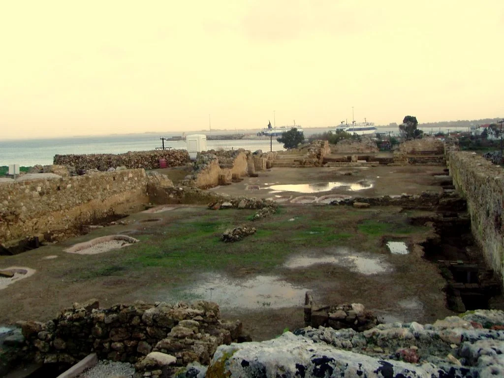
Very little of Glarentza is visible today. The city wall has largely vanished, difficult to trace even from its foundation remains; the port basin is a swamp. The three gates left more substantial traces than the walls between them. A large monumental staircase survives. What remained of the Franciscan church's walls was destroyed by the German Army during the occupation of Greece in World War II.
The site is managed by the 6th Ephorate of Byzantine Antiquities and is accessible to visitors by car. Archaeological work — including the sketch map produced by the antiquarian Ramsay Traquair and published in the Annual of the British School at Athens in 1906/7 — has helped establish the town's layout. The excavated basin where the port once lay, now marshy ground, can still be identified near the cliff edge on the northern side of the headland.
A persistent popular theory once connected the English title Duke of Clarence with this town. That connection was definitively rejected in 1846 by the military antiquarian William Martin Leake, who demonstrated that no English royalty ever held Moreote titles and that the title derives from Clare in Suffolk, not from the Peloponnese.
Silver Coins and Vanished Streets
The tornese coins minted at Glarentza are now found in museum collections across Europe — small silver discs that outlasted the town that produced them by centuries. They were the medium through which the Principality of Achaea participated in Mediterranean commerce, and their survival in archives and coin collections documents an economy that left almost nothing else standing.
Glarentza's story is a compressed version of what happened to the entire Frankish presence in Greece: founded with energy and commercial intelligence, prosperous for two centuries, then undercut by the slow failure of the political system that had sustained it. The Byzantines who inherited it could not restore what the Italian trade networks had built. The Ottomans who followed did not try. The harbor silted. The walls crumbled. The streets disappeared under soil. Where a medieval town once processed the trade of a principality, the Ionian wind now blows across scrubland and marsh.
From the Air
Glarentza's site lies at approximately 37.94°N, 21.14°E, on the northwestern tip of the Chelonatas headland near the modern village of Kyllini, on the westernmost point of the Peloponnese. From the air at 2,000–4,000 feet, the clifftop plateau is identifiable by the headland's distinctive profile where it meets the sea; the swampy harbor basin may be visible in the north. The island of Zakynthos lies roughly 12 km to the northwest across the water. Chlemoutsi castle is visible on its hill approximately 5 km to the south-southeast. The nearest major airport is LGRX (Araxos), approximately 35 km to the northeast.
Nearby Stories
- Astras 4.5 km away
- Heraea (Arcadia) 5.3 km away
- Battle of Lepanto 6.7 km away
- Ionian Islands 9.7 km away
- Saint Gerasimos Monastery 14 km away
- Alpheus (deity) 16 km away
- Salmeniko Castle 19 km away
- 2018 Ionian Sea Earthquake 20 km away