Gorredijk
The writer Jacob van Lennep, on a long walking tour of the Netherlands in 1823, paused near Heerenveen to record an impression of a neighbouring town. 'A little further west', he wrote, 'is the Gordijcke, where there still live some half savages or cavemen, whose houses are half underground and who live from robbery and begging. Of the three criminals who are sentenced in Friesland, one is from that place.' The Gordijcke he meant is the modern Gorredijk, today a quiet Frisian town of about 7,360 people in the municipality of Opsterland. The road in is now an ordinary Dutch B-road. The half-buried houses are gone. The reputation took most of two centuries to outgrow.
A Canal Was the Town
Gorredijk is a vlecke, a particular Dutch settlement type that means roughly trading post village, formed not around a church or a market square but around a canal. The canal in question was the Opsterlandse Compagnonsvaart, and it was the only reason anyone built here. In 1622 there was no waterway through this stretch of peat country. By 1630 a canal is mentioned in writing. Around 1631 the digging of a dike called the Hegedyk is recorded, and that is the moment Gorredijk is considered to have started. A bridge called a hoogholtje, a high wooden footbridge, was built over the gap so peat barges could pass beneath with their masts unstepped. The first house went up next to the bridge. Others followed. The settlement grew in a single line along the water, which is why even today the oldest streets, the Brouwerswal, Kerkewal, Molenwal, and Langewal, all have wal, meaning embankment, in their names.
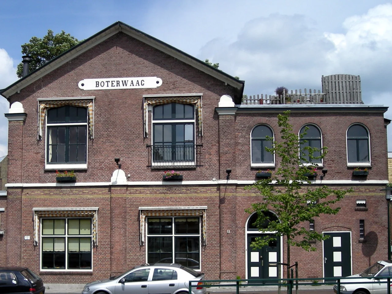
Peat, Poverty, Distilleries
Vast peat bogs once covered this part of southeast Friesland. Excavating them was filthy, freezing, dangerous, badly paid work that nonetheless drew thousands of people to a region that had been almost empty. The peat was floated out through Gorredijk on barges and traded onward. The town granted itself a weekly market from 1694, with a butter weigh house at the Boterwaag and a grain exchange at the Korenbeurs. Both buildings still stand and now hold offices. Industry kept pace: three shipyards, a rope works, two lime kilns, all gone now. The town also took up distilling its own spirits, the bitter Frisian jenever called Beerenburg in particular. The Gerard Brons brand survives, though it is now made by the Boomsma distillery in Leeuwarden. At one point in the early 1900s, the town supported more than 100 'living-room bars', informal pubs run out of people's front rooms.
A Red Town With Many Churches
Gorredijk has long had a reputation as a 'red' town, meaning socialist, and one of the founders of Dutch socialism, Ferdinand Domela Nieuwenhuis, came from the area. Yet for a town that prides itself on its workers' politics, it has built remarkably many churches: a Catholic church, a Protestant congregation, a Mennonite community, a Kingdom Hall of the Jehovah's Witnesses, and a Dutch Reformed parish that has been here since 1683. In 1896 a church bell from the town was sold off; it is now in the collection of the Rijksmuseum in Amsterdam, dated to the twelfth century, its original location unknown. The town also had a substantial Jewish community for centuries. There was a synagogue, a Jewish school, and a cemetery in a meadow on the road to Jubbega that still stands. In the 1880s the Jewish family De Haan lived briefly in Gorredijk; their children Jacob Israel and Carry would become two of the more interesting Dutch authors of the early twentieth century. Only a handful of Gorredijk's Jews survived the Second World War.
Liberation by Drawbridge
The war was relatively quiet here. Friesland's flat empty interior was full of hiding places, and many residents quietly worked with the resistance. On the eve of the country's liberation in April 1945, there was a firefight near the drawbridge on the main street. A young resistance fighter named Gerke Numan was killed. The street where he died now carries his name. In the surrounding fields, several Allied aircraft came down during the occupation, including a British Vickers Wellington bomber whose six crew members are buried together in the local graveyard. None of this turns up in tourist brochures. The town today is the retail and employment hub for a string of smaller villages, with three primary schools, a secondary school, a regional museum housed in an old schoolhouse from 1887, and the kind of unhurried Frisian rhythm in which everyone seems to know where the cemetery, the church bell, and the resistance fighter all came from.
From the Air
Gorredijk sits at 53.00N, 6.07E in southeast Friesland, about 10 kilometres east of Heerenveen. From 3,000 to 5,000 feet the town is recognisable as a slim linear settlement strung along the Opsterlandse Compagnonsvaart canal, with the river bending past on its way northwest toward Drachten. Surrounding land is open Frisian pasture criss-crossed by drainage ditches. Drachten Airport (EHDR) lies about 15 kilometres north for general aviation; Groningen Eelde (EHGG) is roughly 35 kilometres northeast. The A7 motorway runs north of the town, the A32 to the west. Excellent visibility is the norm; low-level mist over the wet pasture is common at dawn.
Nearby Stories
- Murder of Marianne Vaatstra 2.1 km away
- Heeg 3.4 km away
- Meppel 4.4 km away
- Eems Canal 5.8 km away
- Urk 8.1 km away
- Coevorden 8.9 km away
- Zuidlaren 11 km away
- West Frisian Islands 23 km away